
Velasco, Juan López de (sold)

Juan López de Velasco (c. 1530 - 1598) was a Spanish cosmographer and historian. He served as Spain's senior chronicler of the Indies in the second half of the century, during the reign of Philip II. He produced a number of charts of the Americas - of Guatemala, Panama, Chile and Mexico - which would provide the basis of the maps included in Herrera y Tordesillas' 1601 geography of the West Indies. He also created a 51-point rubric for the cataloguing of every town, village or city falling within Philip II's domains.
Earliest Spanish Map Specifically of Chile.
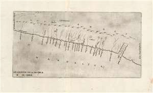
Descripcion De La Provincia De Chile.
sold
- Digital Map Information
- Suitable for large format printing
- Full resolution TIFF file
- ICC color profile embedded
- Delivered instantly via download link
This is the extremely rare 1601, Madrid, first edition of Antonio Herrera y Tordesillas' map of Chile: the first map specifically focused on Chile, and the first to be printed in Spain. Indeed, this is one of the very few early officially-sanctioned Spanish maps of any part of the New World: Spain for the most part maintained a strict policy of secrecy regarding its discoveries in the Americas. This map was included in Herrera's 1601 Descripcion de las Indias Occidentales, the geographical supplement to Herrera y Tordesillas' history of the Spanish exploration of the Americas. (more details)
One of the few early official Spanish Maps of the New World.
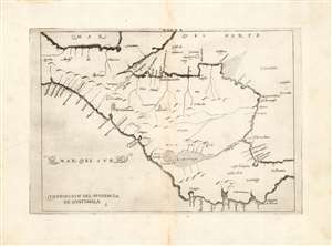
Descripcion del Audiencia de Guatimala.
sold
- Digital Map Information
- Suitable for large format printing
- DPI: 600
- File Size: 5.2 MB
- File Type: ZIP / TIFF
- ICC color profile embedded
- Delivered instantly via download link
This is a handsome example of Antonio de Herrera y Tordesillas' 1726 map of the Audience of Guatemala, which includes modern-day Nicaragua, Costa Rica, Panama, and part of Mexico. It is one of the very few early maps of parts of the New World produced based on official Spanish sources. Spain for the most part maintained a strict policy of secrecy regarding its discoveries in the Americas. It was first included in Herrera's 1601 Descripcion de las Indias Occidentales, the geographical supplement to Herrera y Tordesillas' history of the Spanish exploration of the Americas. (This example is from the second Spanish edition of the work, of 1726. Despite Herrera y Tordesillas not having ever been to the Americas, this work is important in containing geographical information collected by the Spanish in the administration of their colonies, including manuscript charts of Juan López de Velasco. This particular work is one of those derived from Velasco's charts. Interior details are sparse, perhaps due to Spanish concerns of secrecy. Even so, the map shows a number of the chief colonial cities of the region: Santiago de Guatemala, Valladolid, Puerto de Cavallos, and Granada for example. (more details)