
Alessandro della Via (sold)

Alessandro della Via (fl. 1680–1724) was a Veronese engraver and illustrator working in Venice. His cartographic work appears to have been entirely on behalf of Vincenzo Coronelli, in whose shop he was, by 1688. one of the most accomplished artists. It is certain that he executed the plates for the 1688 Venetian edition of Coronelli's 3 1/2 foot celestial globe, which Coronelli declared to be far superior to those executed by Jean Baptiste Nolin for the earlier Paris edition.
Earliest Acquirable Accurate Map of the Southwest?
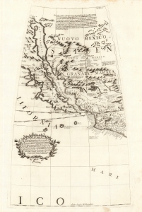
[Untitled Globe Gore of Western North America from the Equator to approximately 50º north].
sold
- Digital Map Information
- Suitable for large format printing
- Full resolution TIFF file
- ICC color profile embedded
- Delivered instantly via download link
This is the globe gore focusing on the American southwest, engraved in 1688 for Vincenzo Coronelli's 42-inch (3 1/2 foot) terrestrial globe, reprinted in 1697 for inclusion in his Libro dei Globi and Isolario. This beautiful engraving is striking in its presentation of the insular California, but this is not its most important feature. Rather it represents the earliest correct depiction of the Rio Grande generally acquirable to the collector. (more details)
The Heart of North America from the Finest Globemaker of the 17th Century.
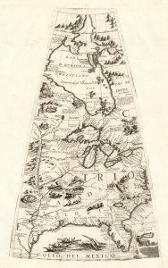
[Untitled Globe Gore of North America from the Tropic of Cancer to the Arctic Circle].
sold
- Digital Map Information
- Suitable for large format printing
- Full resolution TIFF file
- ICC color profile embedded
- Delivered instantly via download link
This is a beautiful 1688 Vincenzo Maria Coronelli globe gore focused on North America east of the Mississippi and west of the Chesapeake, engraved Coronelli's masterpiece 3 1/2 foot globe. The copperplate was adapted in 1697 for inclusion in Coronelli's bound atlases, masked off between the Tropic of Cancer and the Equator to fit book format. The gore covers most of North America east of the Mississippi, spanning from the Tropic of Cancer to the Arctic Circle. Thus, it shows the northern Gulf Coast, Florida, Chesapeake Bay, the Mississippi River (after La Salle), the Great Lakes, and Hudson's Bay. The geography is substantively the same as that on Coronelli's two-sheet America Settentrionale. Although that map bears the date 1688, it was not actually published any earlier than 1690 and it is very probable that the globes represent the earlier appearance of this geographical information. (more details)
The Caribbean and American East Coast from the Finest Printed Globe of the 17th Century.
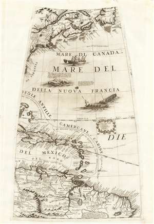
[Untitled Globe Gore of Eastern North and South America from the Equator to approximately 50º north].
sold
- Digital Map Information
- Suitable for large format printing
- Full resolution TIFF file
- ICC color profile embedded
- Delivered instantly via download link
This scarce, beautiful engraving is the globe gore presenting a map of the American northeast, the West Indies, and Terra Firma in South America, engraved in 1688 for Vincenzo Coronelli's 42-inch (3 1/2 foot) terrestrial globe, reprinted in 1697 for inclusion in his Libro dei Globi and Isolario. The map spans from the Equator in the south to Newfoundland in the north, centered on the Tropic of Cancer. It includes Canada in the vicinity of the Saint Lawrence River and Acadia, New England and New York, and part of the coastline around the Chesapeake Bay. The West Indies are shown from the Bahamas to Trinidad, stretching from the eastern part of Cuba to Barbados, including the imaginary island of Fonseca. The gore's southern extents show the northern parts of South America, from modern day Venezuela to the Orinoco Delta and the Guianas, and the fabled city of El Dorado. (more details)
South America from the Finest Globemaker of the 17th Century.
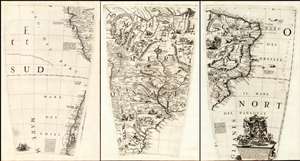
(Set of three Globe Gores of South America from the Equator to 50º south).
sold
- Digital Map Information
- Suitable for large format printing
- Full resolution TIFF file
- ICC color profile embedded
- Delivered instantly via download link
This is a matched trio of globe gore sections covering most of South America, issued by Vincenzo Maria Coronelli in 1697. They are printed from the plates of Coronelli's 1688 3 1/2 foot Terrestrial globe. Coronelli considered the 1688 terrestrial and celestial globe pair to be his greatest work in print. He was not without justification: their superb engraving and encyclopedic geographic detail, not to mention their great size, set them easily amongst the finest globes produced in the 17th century. Desiring to display the quality of these works to a broader audience, and to challenge any potential competition, Coronelli published in 1697 a volume variously titled Libro dei Globi or Palestra Litteraria containing his globe gores (The title page bore a date of 1693, but the earliest known printing of the book was four years later.) 1697 was busy: Coronelli also included most of the gores from his terrestrial globe among conventional maps in his Atlante Veneto and Isolario that same year. In this case, less a product of the mapmaker's braggadocio and more a sensible reuse of expensively-produced copperplates. (more details)
The Caribbean and American East Coast from the Finest Printed Globe of the 17th Century.
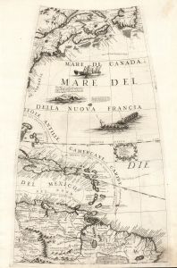
[Globe Gore Map of Eastern North and South America from the Equator to approximately 50º north].
sold
- Digital Map Information
- Suitable for large format printing
- Full resolution TIFF file
- ICC color profile embedded
- Delivered instantly via download link
This is the 1688 / 1697 Vincenzo Coronelli globe gore map of the American northeast, the West Indies, and northern South America. It was initially engraved for Coronelli's 42-inch (3 1/2 foot) terrestrial globe, here in the 1697 printing prepared for the Libro dei Globi and Isolario. (more details)