
Bernardino, Vitali (sold)

Bernardino Vitali or Bernardinus de Vitalibus (fl. 1494 to 1539) was an Albanian printer and publisher, active in Venice but also operating presses in Rome and Rimini. In the first half of the 16th century, he published more than 200 Venetian humanist works. His early life is not understood, although he is thought to have been a refugee - settling in Venice after northern Albania fell to the Ottoman Empire. His Venice print shop opened in 1494, later opening shops in Rome and Rimini. Among his publications were the 1507 and 1508 editions of the Rome Ptolemy, which contained several new maps added to those from the 1478-90 editions: most notably, the famous Ruysch world map.
Earliest Acquirable Printed Map of Arabia.
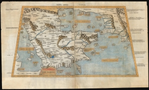
Sexta Asiae Tabula.
sold
- Digital Map Information
- Suitable for large format printing
- Full resolution TIFF file
- ICC color profile embedded
- Delivered instantly via download link
A foundational work of Renaissance cartography: this is the first acquirable printed map of the Arabian Peninsula. Appearing in the Rome edition of Ptolemy, in its 1478 printing, it is preceded only by the unacquirable 1477 Bologna Ptolemy. Ptolemy's 2nd-century innovation of representing the three-dimensional world on a grided mathematical projection provided the basis of all modern cartography. Of all the early printed versions of Ptolemy's maps, those produced for the Rome edition are considered the finest until Mercator's 1578 edition. The present example is embellished with attractive old hand color. (more details)
Finest Early Copperplate Map of the World.
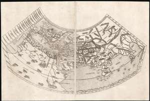
Untitled Map of the World.
sold
- Digital Map Information
- Suitable for large format printing
- Full resolution TIFF file
- ICC color profile embedded
- Delivered instantly via download link
A foundational work of Renaissance cartography: this is the first, acquirable, printed map attempting a measured representation of the known world. The world map from the Rome edition of Ptolemy, in its 1478 printing it is preceded only by the unacquirable 1477 Bologna Ptolemy, the Medieval mappamundi of the Rudimentum Novitorum and the schematic 1472 Isidorus T-O map. Ptolemy's second-century innovation in representing the three-dimensional world with a grid on a projection, using mathematical methods to produce an accurate map, provided the basis of all modern cartography. Of all the early, printed versions of Ptolemy's maps, those produced for the Rome edition are considered to be the finest until Mercator's 1578 edition of the work. (more details)