
Whiteford, R. (sold)

R. Whiteford (fl. c. 1849 – 1856) was a New Haven, Connecticut, based civil engineer and surveyor who was responsible for the 1852 map of the County of New Haven as well as for early town maps of New Haven and Middletown. Although he gives his address as New Haven on the 1852 map, he does not appear in the New Haven city directories. According to Tooley's Dictionary of Mapmakers, Whiteford also contributed to an 1849 map of Burlington County, New Jersey in partnership with J. W. Otley.
Scarce pocket map of New Haven illustrating Yalue University.
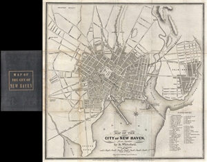
Map of the City of New Haven, from Surveys by R. Whiteford, Civil Engineer.
sold
- Digital Map Information
- Suitable for large format printing
- DPI: 300
- File Size: 4.97 MB
- File Type: ZIP / TIFF
- ICC color profile embedded
- Delivered instantly via download link
A scarce small format pocket map of New Haven, Connecticut, by R. Whiteford. The map covers the city of New Haven and the adjacent Fair-Haven. It extends from East Rock to Oyster Point and from Evergreen Cemetery to the Quinnipiac River. The map identifies ... (more details)