
Yardley, Richard Quincy (sold)
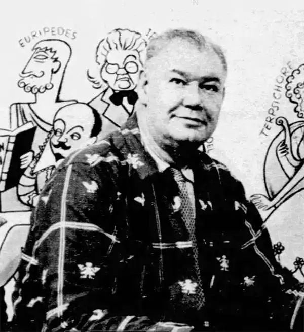
Richard Quincy Yardley (March 11, 1903 - November 24, 1979), known euphemistically as 'Moco,' was an American cartoonist based in Baltimore. Yardley worked as a cartoonist for the Baltimore Sun from 1923. In 1949 he became the editorial cartoonist for the Baltimore Sun, a position he held for roughly 20 years. He also produced cartoons for The Saturday Evening Post, The New Yorker and the Reporter. His syndicated daily comic, Our Ancestors, was published from 1961 to 1965. His work exhibited a humorous satirical style drawing on local personalities and historical events. One writer, Charles Bissell, described his work thus,
His style, which might be described as early Ming, middle comic strip, late Picasso, and all Yardley—or perhaps better some other way-is not suitable for editorial cartoons. To begin with, it's not serious. We all know how you've got to be mighty serious about lots of things-atom bombs, for instance. You couldn't put over something big and profound by drawing a couple of nudeniks with four heads, a little banjo-eyed character in a beret and maybe a cat, all caught up in some sort of symbolical astral soup and expect to scare daylights out of your readers. Well, no, you couldn't—but Yardley can. (AAEC News, April 1964)He issued several satirical cartoon maps, including a map of Herr Hitler's Heaven, Johns Hopkins Hospital, Anne Arundel County, Baltimore County, and Annapolis. Yardley was a member of the National Cartoonists Society, the American Association of Editorial Cartoonists and the National Press Club. He retired in 1972.
Unrecorded Pictorial Map of the U.S. Naval Academy and Annapolis.
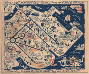
Being a Map of Annapolis Famous Town of Song and Story Attempting to Locate the Naval Academy and Other Places.
sold
- Digital Map Information
- Suitable for large format printing
- Full resolution TIFF file
- ICC color profile embedded
- Delivered instantly via download link
This is a rare c. 1932 hand-colored Peggy and Richard Q. Yardley pictorial map of Annapolis, Maryland, with a focus on the U.S. Naval Academy. It celebrates the history and character of both the institution and the city in humorous fashion. (more details)
Scarcce example of Richard Q. Yardley's work.
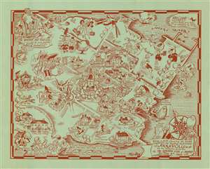
Being a MAP showing the MORE COLONIAL and Nautical FEATURES of ANNAPOLIS on the Occasion of the visit of the GARDEN CLUB of AMERICA.
sold
- Digital Map Information
- Suitable for large format printing
- File Size: 28.84 MB
- File Type: ZIP / TIFF
- ICC color profile embedded
- Delivered instantly via download link
A charming Richard Q. Yardley pictorial map of Annapolis, Maryland issued in 1940 by the Garden Club of America to commemorate their visit to said city. Printed with striking red ink on blue-green paper, this mapis oriented generally to the north. The map is centered on the State house, constructed in 1772, with the United States Naval Academy occupying the upper right quadrant. Local characters, historical buildings, and historian annotations appear throughout in Yardley's inimitable style. (more details)
Charming pictorial map highlighting the unique character of the Delmarva Peninsula (Chesapeake Bay).
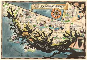
A Map of the Eastern Shore … Rich in History, Romance and (yum) Seafood.
sold
- Digital Map Information
- Suitable for large format printing
- File Size: 34.55 MB
- File Type: ZIP / TIFF
- ICC color profile embedded
- Delivered instantly via download link
This is Richard Q. Yardley's charming map of the eastern shore of the Chesapeake Bay. Comprising most of the Maryland portion of the Delmarva Peninsula, the map is oriented to the east and covers, roughly, Cecil, Kent, Queen Anne's, Caroline, Talbot, Dorchester, Wiscomsco, Worcester, and Somerset counties. Areas to the east and west, including Delaware ('Unexplored Territories') and the Western Shore of the Chesapeake Bay (with the exception of Baltimore and Annapolis) are shaded dark blue. Colorful vignette illustrations with humorous annotations fill the focus area, some lionizing local characters, lifestyle, history, and folklore; others gently poking fun at 'mainlanders.'
As reporter B. Drumond Ayres wrote in the September 12, 1982 New York Times,
As reporter B. Drumond Ayres wrote in the September 12, 1982 New York Times,
The Eastern Shore is a land for all seasons. But none quite compares with early fall, that wonderfully ambivalent time of fullness and decline, when the sea trout are still biting, doves are beginning to fly, a few fat tomatoes still cling to the vine, and the night air, although still alive with the chirp of crickets, provides excuse enough for the season's first wood fire. And this is the bargain season, the two-for-one time.He goes on to describe the independent personality of the region, suggesting it is more akin to an island than a peninsula. (more details)
…
The lay of the land, the language of the people, their food, their homes, their pursuits -these things tend to have a certain distinctiveness not found on the more homogenized mainland lying to the west across the broad marshes and waters of the Chesapeake.