
Bowen, John T. (sold)

John T. Bowen (b. c. 1801 - 1856) was a lithographer active in Philadelphia during the mid-19th century. Born in England, Bowen immigrated to the United States in 1834 and worked as a colorist and lithographer in New York City before moving to Philadelphia in 1838, most like with his collaborator and lithographic artist Alfred Hoffy. Once in Philadelphia, Bowen took over the business of Wild and Chevalier, located at 94 Walnut Street, and began publishing History of the Indian Tribes by McKenney and Hall. He also acquired the rights to Wild and Chevalier's series of views of Philadelphia, which he reissued at the end of 1838 and again in a hand colored edition in 1848. By the early 1840s, Bowen's work was garnering praise, and gained a reputation as one of the best lithographers in Philadelphia. He published the 'Architect's Digest' in 1839 and printed plates for Audubon's Quadrupeds (1845 - 1848) and the octavo edition of Birds of America (1839 - 1844). Despite numerous successes, Bowen field for bankruptcy in 1842, though it did not prove to be too much of a hindrance to his career, as, after 1844, he began working predominantly with Audubon and his sons on their works. Over the course of his career, Bowen became the preeminent Philadelphia lithographer and the most important mid-19th century American publisher of publication plates. By Bowen's death in 1856, he had a fairly substantial estate and a prosperous business. His wife, Lavinia, with whom he had a son, took over the business after her husband's passing and the firm Bowen and Company operated until around 1870.
Early Depiction of Native Americans on the Upper Missouri.
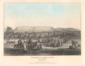
Encampment of Piekann Indians. Near Fort McKenzie on the Muscleshell River.
sold
- Digital Map Information
- Suitable for large format printing
- File Size: 17.25 MB
- File Type: ZIP / TIFF
- ICC color profile embedded
- Delivered instantly via download link
This is a rare 1842 view of an encampment of Piegan Blackfeet near Fort McKenzie, a trading post on the Upper Missouri River in today's Montana. It is based on an 1833 drawing by Karl Bodmer, a member of a scientific expedition to the American frontier led by the German naturalist Prince Maximilian of Wied-Neuwied, whose dramatic, colorful portrayals of Plains Indians were among the earliest to become widely known in both America and Europe. (more details)
Important early Civil War Map illustrating the first major Union victory on the Mississippi River at New Madrid or the Kentucky Bend.
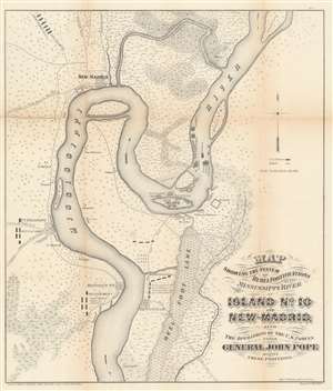
Map showing the system of rebel fortifications on the Mississippi River at Island No. 10 and New Madrid, also the operations of the U.S. forces under General John Pope against these positions.
sold
- Digital Map Information
- Suitable for large format printing
- File Size: 20.91 MB
- File Type: ZIP / TIFF
- ICC color profile embedded
- Delivered instantly via download link
A scarce and important 1862 Civil War map illustrating the course of the Mississippi River in the vicinity of New Madrid, Point Pleasant, Riddles Point, and Tiptonville. This region, collectively known as the Kentucky Bend, is situated at the meeting point of Missouri, Kentucky, and Tennessee. The map was prepared by Major General John Pope, a Union Commander, to illustrate his decisive siege and take over the strategically situated and heavily fortified Island No. 10. Located just upriver from New Madrid, Island No. 10 is situated at a sharp northward curve in the Mississippi. The Confederate Army fortified the island realizing that, if they could control Island No. 10, they could effectively prevent Union forces from using the Mississippi as gateway to the Deep South. (more details)
Important early Civil War Map illustrating the first major Union victory on the Mississippi River at New Madrid or the Kentucky Bend.
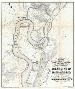
Map showing the system of rebel fortifications on the Mississippi River at Island No. 10 and New Madrid, also the operations of the U.S. forces under General John Pope against these positions.
sold
- Digital Map Information
- Suitable for large format printing
- File Size: 11.68 MB
- File Type: ZIP / TIFF
- ICC color profile embedded
- Delivered instantly via download link
A scarce and important 1862 Civil War map illustrating the course of the Mississippi River in the vicinity of New Madrid, Point Pleasant, Riddles Point, and Tiptonville. This region, collectively known as the Kentucky Bend, is situated at the meeting point of ... (more details)
From a captured Confederate photograph map.
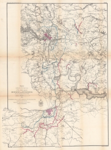
Region embraced in the Operations of the Armies against Richmond and Petersburg.
sold
- Digital Map Information
- Suitable for large format printing
- File Size: 85.46 MB
- File Type: ZIP / TIFF
- ICC color profile embedded
- Delivered instantly via download link
This is an 1865 War Department map of Richmond and Petersburg, Virginia, and Environs. This piece presents the military situation near the end of the Richmond-Petersburg Campaign of the American Civil War (1861 - 1865). It was partially compiled from a captured Confederate photograph map. (more details)
Surveys and Minerals.
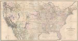
Map of the United States and Territories, Showing the extent of Public Surveys and other details, Constructed from the Plats and official sources of the General Land Office.
sold
- Digital Map Information
- Suitable for large format printing
- File Size: 103.75 MB
- File Type: ZIP / TIFF
- ICC color profile embedded
- Delivered instantly via download link
This is an 1867 Joseph S. Wilson and Joseph Gorlinsky map of the United States illustrating the progress of U.S. government land surveys from coast to coast. The map depicts the entire United States from the Pacific Ocean to the Atlantic Ocean and from Canada to Mexico. (more details)