
Carteret, Philip Seigneur of Trinity (sold)

Philip Carteret, Seigneur of Trinity (January 22, 1733 - July 21 1796) was a British naval officer and explorer who participated in two of the Royal Navy's circumnavigation expeditions in 1764–66 and 1766–69. He served as a lieutenant aboard HMS Dolphin under Byron during his voyage of circumnavigation from June 1764 to May 1766. Later that year he was made commander and given the command of HMS Swallow to circumnavigate the world, as supporting HMS Dolphin under the command of Samuel Wallis. The two ships were separated after passing through the Strait of Magellan, but Carteret continued his circumnavigation aboard Swallow. During the voyage he discovered both Pitcairn Island and the Carteret Islands, which were subsequently named after him. In 1767, he discovered a new archipelago inside Saint George's Channel between New Ireland and New Britain Islands, and rediscovered the Solomon Islands first sighted by the Spaniard Álvaro de Mendaña in 1568, and the Juan Fernández Islands first discovered by Juan Fernández in 1574.
A Chart of Pitcairn Island as Carteret Found It
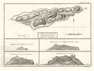
Carte et Vues de l'Isle Pitcairn.
sold
- Digital Map Information
- Suitable for large format printing
- DPI: 600
- File Size: 4.66 MB
- File Type: ZIP / TIFF
- ICC color profile embedded
- Delivered instantly via download link
This is a 1774 map of Pitcairn Island, encountered first by Europeans on Captain Carteret's circumnavigation of 1767. HMS Swallow having been separated from the other ship of the expedition and gripped with scurvy, the opportunity for resupply would have been tantalizing. It was not, however, to be:
We continued our course westward till the evening of Thursday the 2d of July when we discovered land to the northward of us. Upon approaching it the next day, it appeared like a great rock rising out of the sea: it was not more than five miles in circumference, and seemed to be uninhabited; it was, however, covered with trees, and we saw a small stream of fresh water running down one side of it. I would have landed upon it, but the surf, which at this season broke upon it with great violence, rendered it impossible.The island was first spotted by fifteen-year-old midshipman Robert Pitcairn, and so named after him. (The unfortunate middie would die at sea three years later.) As Carteret was unable to survey the island by foot, the interior topography must be construed as speculative, based on the analysis of the views of the island taken from sea. The breakers along the souther shore of the island and the rough coastline that so discouraged the explorer are discernible in the views. (more details)
Fascinating Chart Tracking Four Great Circumnavigators' Passage through the Society Islands
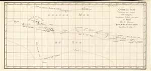
Carte Des Isles Decouvertes Aux Environs D'Otahiti, dans Plusieurs Voyages Faits Autour Du Monde Par Les Capitaines Byron, Wallis, Carteret et Cook. En 1765, 1767,1769.
sold
- Digital Map Information
- Suitable for large format printing
- DPI: 600
- File Size: 10.93 MB
- File Type: ZIP / TIFF
- ICC color profile embedded
- Delivered instantly via download link
This is a 1774 map showing the explorations of Captains Cook, Byron, Wallis and Carteret in the vicinity of Tahiti and the Society Islands from 1765 to 1769. The chart extends from the Scilly Islands in the west to Whitsunday Island in the east, and from Tepoto Island in the north to Oheiroa in the south. Each of the circumnavigators' tracks are shown as they tacked through the islands. Tahiti, Bora Bora, Otaha, Marma, Ulietea, and other islands are named and shown. These voyages represented the first recorded European contacts with many of these remote places. (more details)