
Clark, Blake Everett (sold)

Blake Everett Clark (June 22, 1900 - January 17, 1979) was an American artist. Born in Somerville, Massachusetts, the son of a stockbroker, Clark studied at Milton Academy (1917). ON graduation he went to France to serve in World War I (1914 - 1818) with the 301st Ambulance Detail Battery. On his return not the United States, he enrolled in Bowdoin College (1923), and Tufts College. He then moved to Paris where he studied art at the Académie Delécluse, Montparnasse. He returned to Boston by 1925, where he pursued a career in marine and landscape painting. During this time, he painted a second home in Ogunquit, Maine. While living in Boston, Clark collaborated with Edwin Birger Olsen (1902 - 1996) on a series of three pictorial maps: The Colour of An Old City: A Map of Boston Decorative and Historical (1926), A Kite View of Philadelphia and the Sesqui-Centennial International Exposition (1926), and Map of the City of Washington in the District of Columbia shewing the Architecture and History from the most Ancient Times down the Present (1926). He married Muriel Cooley in the 1930s, and settled in Brooklyn, New York, where he worked as an artist and a buyer at a department store. He disappears in subsequent decades, but reappears in Arizona in 1964, when he issued a pictorial map of that state, A New Mappe of Ye Old Arizona. He died in Maricopa, Arizona, in 1979.
One of the first separately issued pictorial maps published in the United States.
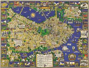
The Colour of an Old City A Map of Boston decorative and historical.
sold
- Digital Map Information
- Suitable for large format printing
- File Size: 96.22 MB
- File Type: ZIP / TIFF
- ICC color profile embedded
- Delivered instantly via download link
One of the first separately issued pictorial maps published in the United States, this is Edwin Birger Olsen and Blake Everett Clark's 1926 pictorial map of Boston. Centered on historic downtown Boston, the map depicts the city from Boylston Street to East Boston and from Cambridge to South Boston. Stunningly illustrated, Olsen and Clark blend together all the aspects that have come to be associated with pictorial cartography. Numerous sites throughout the city are drawn in profile, including the State House, the Custom House, North Station, Trinity Church, and Old North Church. Myriad streets are labeled, as are Boston Common and the Fens. Trains are busily steaming into and out of the city, while vintage sailing ships, such as the Mayflower, Captain Kidd's flagship, and the Flying Dutchman ply the waters of Boston Harbor. Airplanes, fairly modern invention that would change life in the 20th century, fly through the air over the Basin and the Charles River. The border consists of vignettes of historical sites and events around the city, including the Boston Tea Party during the American Revolution and a view of Tremont Street in 1798. Six historic maps of Boston are also reimagined along both sides. (more details)
'Let us satisfy our eyes...'
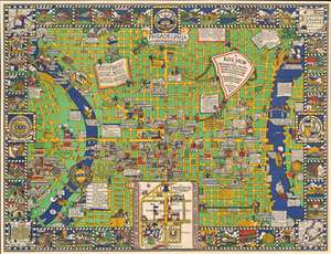
A Kite View of Philadelphia and the Sesqui Centennial International Exposition.
sold
- Digital Map Information
- Suitable for large format printing
- Full resolution TIFF file
- ICC color profile embedded
- Delivered instantly via download link
This is Edwin Birger Olsen and Blake Everett Clark's 1926 pictorial map of Philadelphia, one of the first separately issued pictorial maps published in the United States. Centered historic downtown area, the map colorfully depicts Philadelphia from Gipard Avenue in the north, to Washington Avenue in the south, and between the University of Pennsylvania and the Delaware River. (more details)