
Dumas-Vorzet, Ernest (sold)

Ernest Dumas-Vorzet (18?? - 18??) was a French line and letter engraver active in Paris in the late 19th century. He engraved the lettering on nautical charts for the Dépôt des Cartes et Plans de la Marine. His later work is often associated with Émile Delaune (18?? - 19??) and Hachette et Cie. He is likely the father of Edouard Dumas-Vorzet, a French publisher and cartographer.
Innovative composite of quantitative and qualitative wind data.
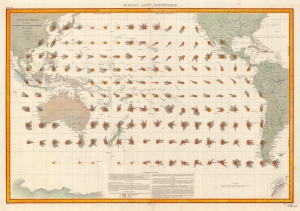
Océan Pacific - Cartes de la Direction et de l'Intensité Probables des Vents. Juillet Août Septembre.
sold
- Digital Map Information
- Suitable for large format printing
- File Size: 49.88 MB
- File Type: ZIP / TIFF
- ICC color profile embedded
- Delivered instantly via download link
This is an 1880 Léon Brault significant map of Pacific Ocean winds. The map is innovative in its expression of both quantitative and qualitative data in relation to wind direction, intensity, and frequency - presaging the work of Matthew Fontaine Maury (1806 - 1873) in the mid-19th century. (more details)
'An orientalist's fantasy...'
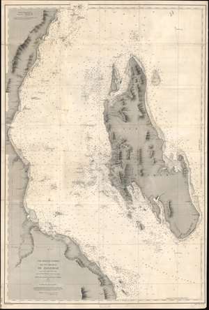
Côte Orientale d'Afrique. Ile et Chenaux de Zanzibar d'aprés le levé exécuté en 1873 et 1874.
sold
- Digital Map Information
- Suitable for large format printing
- File Size: 40.13 MB
- File Type: ZIP / TIFF
- ICC color profile embedded
- Delivered instantly via download link
An extremely rare 1891 French spice trade nautical chart or maritime map of Zanzibar Island or Unguja, off the coast of modern-day Tanzania. This is among the most detailed 19th century maps focusing on Zanzibar we have encountered. Coverage embraces the entire island as well as, the Zanzibar Channel, and the modern-day Tanzania coast from just south of Pemba Island to just north of Dar es Salaam. The largest town shown on the Africa coast is Bagamoyo. On the island, spice plantations are marked by clusters of palm trees and buildings. There are some manuscript updates and revisions around Stone Town. (more details)
Georgia and South Carolina Coasts.
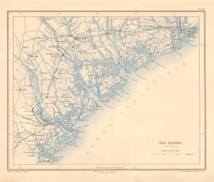
Sea Islands (Caroline due Sud).
sold
- Digital Map Information
- Suitable for large format printing
- File Size: 7.96 MB
- File Type: ZIP / TIFF
- ICC color profile embedded
- Delivered instantly via download link
This is a striking 1890 Dumas Vorzet map of the coasts of South Carolina and Georgia, issued to illustrate the scarce atlas volume of the French edition of Price Philippe d'Orléans' Histoire de la Guerre Civile en Amérique. (more details)
The Bloodiest Day in U.S. Military History.
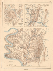
Cedar Mountain (Virginie). Harpers Ferry et South Mountain. Antietam (Maryland).
sold
- Digital Map Information
- Suitable for large format printing
- Full resolution TIFF file
- ICC color profile embedded
- Delivered instantly via download link
This is Ernest Dumas-Vorzet's map of the 1862 Civil War Battles of Cedar Mountain, Harpers Ferry, and Antietam, issued to illustrate the 1890 book Histoire de la Guerre Civile en Amérique. (more details)
Crucible of the Civil War.
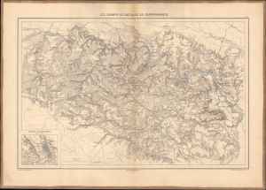
Les champs de bataille du Rappahannock.
sold
- Digital Map Information
- Suitable for large format printing
- File Size: 26.28 MB
- File Type: ZIP / TIFF
- ICC color profile embedded
- Delivered instantly via download link
This 1890 Dumas Vorzet map displays eastern Virginia south of the Rappahannock River, the site of several important battles in the U.S. Civil War. It appeared in the scarce 1890 atlas volume of the French edition of Philippe d'Orléans' Histoire de la Guerre Civile en Amérique. (more details)
Capturing the Crescent City.
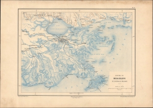
Bouches du Mississippi et Nouvelle Orleans.
sold
- Digital Map Information
- Suitable for large format printing
- File Size: 13.43 MB
- File Type: ZIP / TIFF
- ICC color profile embedded
- Delivered instantly via download link
A remarkable map of the Mississippi River Delta, New Orleans, and environs, prepared in 1890 by Ernest Dumas-Vorzet. It appeared in the scarce 1890 atlas volume of the French edition of Philippe d'Orléans' Histoire de la Guerre Civile en Amérique. (more details)
A French Prince in the American Civil War.
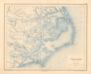
Pamlico Sound (Caroline du Nord).
sold
- Digital Map Information
- Suitable for large format printing
- File Size: 9.12 MB
- File Type: ZIP / TIFF
- ICC color profile embedded
- Delivered instantly via download link
This is a striking 1890 Dumas Vorzet map of the Pamlico Sound and Albemarle Sound, eastern North Carolina, issued to illustrate the scarce atlas volume of the French edition of the Prince Philippe d'Orléans' Histoire de la Guerre Civile en Amérique. (more details)
Emergence of 'the Grey Ghost'
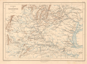
Environs de Warrenton (Virginie).
sold
- Digital Map Information
- Suitable for large format printing
- File Size: 7.95 MB
- File Type: ZIP / TIFF
- ICC color profile embedded
- Delivered instantly via download link
This is Ernest Dumas-Vorzet's 1890 map of Warrenton, Virginia and environs, prepared for his Histoire de la Guerre Civile en Amérique. It relates to the 1863 American Civil War (1861 - 1865) Warrenton Junction Raid, one of the first significant actions of 'the Gray Ghost', Confederate commander John S. Mosby and his eponymous Mosby’s Rangers. (more details)
Georgia and South Carolina Coasts.
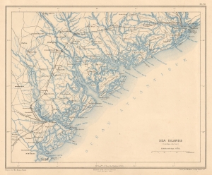
Sea Islands (Caroline due Sud).
sold
- Digital Map Information
- Suitable for large format printing
- File Size: 7.55 MB
- File Type: ZIP / TIFF
- ICC color profile embedded
- Delivered instantly via download link
This is a striking 1890 Dumas Vorzet map of the coasts of South Carolina and Georgia, issued to illustrate the scarce atlas volume of the French edition of Price Philippe d'Orléans' Histoire de la Guerre Civile en Amérique. (more details)
A House Divided...
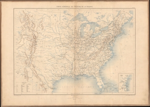
Carte générale du théâtre de la guerre.
sold
- Digital Map Information
- Suitable for large format printing
- Full resolution TIFF file
- ICC color profile embedded
- Delivered instantly via download link
This is Ernest Dumas-Vorzet's 1890 map of the United States, prepared for Histoire de la Guerre Civile en Amérique. It was the first map in the atlas volume accompanying the book. (more details)
An Imperiled Capital.
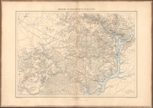
Environs de Washington et du Bull Run.
sold
- Digital Map Information
- Suitable for large format printing
- File Size: 21.94 MB
- File Type: ZIP / TIFF
- ICC color profile embedded
- Delivered instantly via download link
This is an 1890 Dumas Vorzet map of Washington, D.C., and its environs in eastern Virginia, the scene for multiple important battles during the American Civil War (1861 - 1865), issued as part of the scarce atlas volume of the French edition of Philippe d'Orléans' Histoire de la Guerre Civile en Amérique. (more details)