
Edwards, Parker (sold)

Parker Edwards (1911 - September 17, 1987) was a Hawaii based painter and illustrator. Edwards worked primarily in the medium of watercolors and was known for his "tiki" inspired imagery. Edwards was the third husband of the well-known writer, Peggy Bracken. In cartographic circles he is known for his iconic pictorial map of the Hawaiian Islands issued for the Dole Pineapple Company.
Iconic promotional map of Hawaii from its Territorial Period.
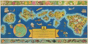
The Dole Map of the Hawaiian Islands U.S.A. Being a descriptive portrayal of the history, transportation, industries and geography of the Territory of Hawaii, U.S.A.`
sold
- Digital Map Information
- Suitable for large format printing
- File Size: 28.98 MB
- File Type: ZIP / TIFF
- ICC color profile embedded
- Delivered instantly via download link
A bright and colorful 1937 pictorial map of Hawaii drawn by Parker Edwards and issued by the Dole Pineapple Company. One of the most iconic pictorial maps of Hawaii from its territorial period, this is an early attempt to highlight the archipelago's wonders and ... (more details)
Iconic promotional map of Hawaii from its territorial period.
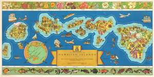
The Dole Map of the Hawaiian Islands U.S.A. Being a descriptive portrayal of the history, transportation, industries and geography of the Territory of Hawaii, U.S.A.`
sold
- Digital Map Information
- Suitable for large format printing
- File Size: 12.67 MB
- File Type: ZIP / TIFF
- ICC color profile embedded
- Delivered instantly via download link
This is a 1937 pictorial map of the Hawaiian Archipelago drawn by Parker Edwards and issued by the Dole Pineapple Company. The map depicts the Hawaiian Islands of Hawaii, Maui, Kahoolawe, Lanai, Molokai, Oahu, Kauai, and Niihau. Pictorial vignettes decorate each ... (more details)
Iconic promotional map of Hawaii from its territorial period.
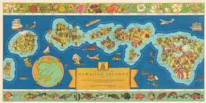
The Dole Map of the Hawaiian Islands U.S.A. Being a descriptive portrayal of the history, transportation, industries and geography of the Territory of Hawaii, U.S.A.
sold
- Digital Map Information
- Suitable for large format printing
- File Size: 39.5 MB
- File Type: ZIP / TIFF
- ICC color profile embedded
- Delivered instantly via download link
One of the most iconic pictorial maps of Hawaii from its territorial period, this 1937 pictorial map of the Hawaiian Archipelago drawn by Parker Edwards and issued by the Dole Pineapple Company represents an early attempt to highlight the archipelago's wonders and attract tourists. Depicting the Hawaiian Islands of Hawaii, Maui, Kahoolawe, Lanai, Molokai, Oahu, Kauai, and Niihau, pictorial vignettes decorate each island and relate scenes of daily life, tourist 'attractions,' and Hawaiian history. On Hawaii, for example, each of the volcanoes is labeled, and their elevations are provided. The lava flows from the many eruptions are illustrated as well. Boats and Clipper aircraft are included. Pearl Harbor is labeled. Several aspects of Dole's operation in the islands, including pineapple plantations, Dole canneries, etc. also are depicted. The upper border includes drawings of Hawaiian flora. In contrast, the lower border highlights sea life native to the archipelago. (more details)
Iconic promotional map of Hawaii from its Territorial Period.
The Dole Map of the Hawaiian Islands U.S.A. Being a descriptive portrayal of the history, transportation, industries and geography of the Territory of Hawaii, U.S.A.`
sold
- Digital Map Information
- Suitable for large format printing
- File Size: 16.93 MB
- File Type: ZIP / TIFF
- ICC color profile embedded
- Delivered instantly via download link
This is a 1937 pictorial map of the Hawaiian Archipelago drawn by Parker Edwards and issued by the Dole Pineapple Company. The map depicts the Hawaiian Islands of Hawaii, Maui, Kahoolawe, Lanai, Molokai, Oahu, Kauai, and Niihau. Pictorial vignettes decorate each ... (more details)
Iconic pictorial map of Hawaii.
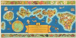
The Dole Map of the Hawaiian Islands U.S.A. Being a descriptive portrayal of the history, transportation, industries and geography of the Territory of Hawaii, U.S.A.
sold
- Digital Map Information
- Suitable for large format printing
- File Size: 38.85 MB
- File Type: ZIP / TIFF
- ICC color profile embedded
- Delivered instantly via download link
One of the most iconic pictorial maps of Hawaii from its territorial period. This 1937 Parker Edwards pictorial map of the Hawaiian Archipelago was issued by the Dole Pineapple Company to highlight the islands and Dole's business interests. Depicting the Hawaiian Islands of Hawaii, Maui, Kahoolawe, Lanai, Molokai, Oahu, Kauai, and Niihau, pictorial vignettes decorate each island and relate scenes of daily life, tourist 'attractions,' and Hawaiian history. On Hawaii, for example, each volcano is labeled with elevations provided. The lava flows from the many eruptions are illustrated as well. Pearl Harbor - not yet the site of an infamous attack - is labeled. Several aspects of Dole's operation in the islands, including pineapple plantations, Dole canneries, etc. also are depicted. The upper border includes drawings of Hawaiian flora. In contrast, the lower border highlights resident sea life. (more details)
The only known example of a pictorial map romanticizing and chronicling life in the Old West.
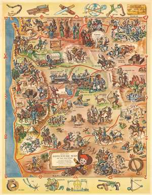
Rancho Red's Adventure Map of the Old West. An Authentic Pictorial Map Illustrating the Most Important Historical Events in the Development of the West from 1800 - 1900.
sold
- Digital Map Information
- Suitable for large format printing
- File Size: 40.25 MB
- File Type: ZIP / TIFF
- ICC color profile embedded
- Delivered instantly via download link
Romanticized vignettes of life in the American West, along with illustrations of historical events, provide a narrative of adventure, danger, exploration, fortune hunting, and war during one hundred years of American expansion to this extremely rare 1951 Parker Edwards pictorial map. The map depicts the Old West from the Pacific Ocean to Wyoming, Colorado, and New Mexico and from Canada to the U.S.-Mexico border. Cowboys, perhaps the most romanticized piece of lore associated with the American West, are drawn evading stampeding cattle in one part of the map, while in another they are roping and branding calves. Lawmen and outlaws are seen in a shootout at Tombstone, Arizona, but Black Bart, the outlaw known for robbing stagecoaches in northern California and southern Oregon, illustrated doing just that. Native Americans, the other half of the 'Cowboys and Indians' game children play to this day, are present as well. Some are shown in the middle of a war dance, while Chief Ouray of the Utes is hunting deer in the 'happy hunting ground'.
Native Americans also appear in several of the historical events highlighted in these vignettes. Sacagawea is included guiding Lewis and Clark on their historic expedition, as are the Lakota and the other tribes exacting their revenge on Lieutenant Colonel George Armstrong Custer and the U.S. 7th Cavalry at the Battle of Little Bighorn. The great warriors Chief Cochise and Geronimo are also referenced. Gold rushes in California and Colorado are noted, with James Marshall illustrated as Sutter's Mill, the site of the beginning of the California Gold Rush. The natural beauty of the West is also on display, with illustrations of the Grand Canyon and Monument Valley appearing in Arizona and Old Faithful marks Yellowstone in Wyoming. Other prominent figures and events in the history of the American West illustrated here include Colonel William 'Buffalo Bill' Cody, Kit Carson, and John Fremont, along with the completion of the transcontinental railroad, the Pony Express, and the Oregon Trail. Illustrations of objects important to life in the Old West, including stirrups, spurs, a Colt pistol, a Bowie knife, and miner's tools, are included along the top and bottom border. (more details)
Native Americans also appear in several of the historical events highlighted in these vignettes. Sacagawea is included guiding Lewis and Clark on their historic expedition, as are the Lakota and the other tribes exacting their revenge on Lieutenant Colonel George Armstrong Custer and the U.S. 7th Cavalry at the Battle of Little Bighorn. The great warriors Chief Cochise and Geronimo are also referenced. Gold rushes in California and Colorado are noted, with James Marshall illustrated as Sutter's Mill, the site of the beginning of the California Gold Rush. The natural beauty of the West is also on display, with illustrations of the Grand Canyon and Monument Valley appearing in Arizona and Old Faithful marks Yellowstone in Wyoming. Other prominent figures and events in the history of the American West illustrated here include Colonel William 'Buffalo Bill' Cody, Kit Carson, and John Fremont, along with the completion of the transcontinental railroad, the Pony Express, and the Oregon Trail. Illustrations of objects important to life in the Old West, including stirrups, spurs, a Colt pistol, a Bowie knife, and miner's tools, are included along the top and bottom border. (more details)