
Escuela de Artes Y Oficios (sold)

La Escuela de Artes Y Oficios (1878 - 1887) was a school developed in Montevideo, Uruguay, as part of that country's modernization process, both as an instrument of education and of social control. It was founded on December 31, 1878, during the presidency of Lorenzo Latorre. At that time it was located within a military compound and was administered directly by the Ministry of War: its students were young people detained by the police or the army. These were taught to read, and instructed in a trade during their detention. Printing - both letterpress and lithography - appear to have numbered among these trades: the school published an array of works during its existence, ranging from books of poetry to official statistical government publications. They published at least one map: Mapa de la republica oriental del Uruguay, whose cartographer is not credited. Its publication through a military office would classify it as an official document. The Escuela remained an office of the military until 1887, at which point it was passed to the Ministry of Justice, Worship and Public Instruction, and its name changed to Escuela Nacional de Artes y Oficios, under the administration of Roberto Arménio. The institution survived several changes of name, and is known now as Univesidad del Trabajo del Uruguay.
Most beautiful early Uruguayan map of Uruguay.
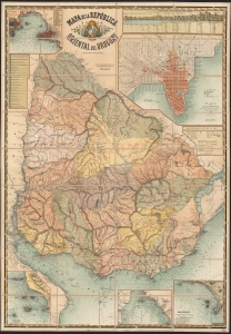
Mapa de la República oriental del Uruguay.
sold
- Digital Map Information
- Suitable for large format printing
- File Size: 2358.68 MB
- File Type: ZIP / TIFF
- ICC color profile embedded
- Delivered instantly via download link
This is a spectacular, folding chromolithograph map of the Republic of Uruguay, published c. 1884 by Uruguay's La Escuela de Artes Y Oficios. It is among the first maps of Uruguay published there, and it appears to be the first official map of the Republic. (more details)
Massacre at Paso de Quinteros.
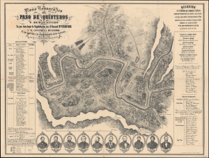
Plano topográfico del Paso de Quinteros y demás sitios en que tuvo lugar la capitulación del Gral. César Díaz y se consumó la hecatombe en que aquel Gefe y sus demás compañeros fueron asesinados en los días 1 y 2 y siguientes del mes de febrero del año 1858.
sold
- Digital Map Information
- Suitable for large format printing
- File Size: 49.73 MB
- File Type: ZIP / TIFF
- ICC color profile embedded
- Delivered instantly via download link
A richly detailed c. 1885 historical map of the Paso de Quinteros along the Rio Negro in Uruguay, produced by the Escuela de Artes y Oficios. It commemorates a massacre that took place there in 1858, following an uprising the previous year, an episode in a decades-long Uruguayan Civil War. (more details)
Rare reference maps for the use of the military.
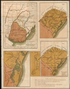
[Mapa Militar de la República O. del Uruguay. 1885, Maps 2, 3, 4, 6, and 7 of]
sold
- Digital Map Information
- Suitable for large format printing
- File Size: 18.76 MB
- File Type: ZIP / TIFF
- ICC color profile embedded
- Delivered instantly via download link
This is a rare, folding chromolithograph containing five maps focusing on Uruguay's frontiers with Brazil, specifically Rio Grande do Sul, produced in 1885 by military engineer Roberto Arménio for the use of officers of the Uruguayan Army and Navy. It accompanied Arménio's pamphlet, Mapa Militar de la República Oriental del Uruguay, which outlined plans to reform and modernize Uruguay's military. (more details)
Maps for the use by the Uruguan military.
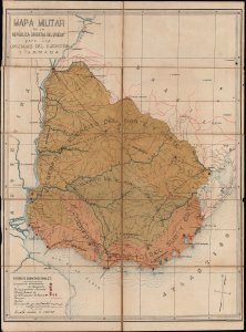
Mapa Militar de la República O. del Uruguay. 1885 [Maps 1 and 5 of 7]
sold
- Digital Map Information
- Suitable for large format printing
- Full resolution TIFF file
- ICC color profile embedded
- Delivered instantly via download link
These are Roberto Arménio's rare maps focusing on Uruguay's frontiers with Brazil and Argentina: one showing the administrative regions of the Uruguayan Army overall, and the other detailing Uruguay's fortifications along the Uruguay River (which forms the Uruguayan border with Argentina). These were produced in 1885 for the use of officers of the Uruguayan Army and Navy, and appeared in Arménio's pamphlet, Mapa Militar de la República Oriental del Uruguay, which outlined ambitious plans to reform and modernize Uruguay's military. The two maps are offered in conjunction with the pamphlet. (more details)