
Flemming, Carl (sold)

Carl Flemming (fl. c. 1840 - c. 1879) was a German cartographer and map publisher active in the late 19th and early 20th centuries. The firm was an early adopter of modern multicolor printing techniques, which it utilized to produce low cost attractive maps focused on the German market. The firm is also known for its children's books. Flemming died in 1878 or 1879, but his firm continued to publish well into the 20th century. Flemming was based in Glogow, a region that is currently part of modern day Poland's Lower Silesian Voivodeship.
German mapping of the Republic of Texas.
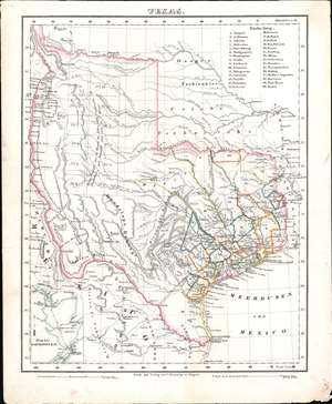
Texas.
sold
- Digital Map Information
- Suitable for large format printing
- DPI: 600
- File Size: 9.07 MB
- File Type: ZIP / TIFF
- ICC color profile embedded
- Delivered instantly via download link
This is a c. 1846 Carl Flemming map of Texas shortly after the Republic of Texas was annexed into the United States (1845). Based on John Arrowsmith's map, Flemming identifies thirty counties in eastern and southeastern Texas, labels them numerically, and provides the county names in a table in the upper right. Numerous settlements are noted along the Rio Grande River in what is today New Mexico. An inset of Galveston Bay is situated in the lower left corner. Flemming also includes an erroneous annotations originally printed on the Arrowsmith map regarding the arid region of western Texas, 'This tract of Country explored by Le Grande in 1833 is naturally fertile, well wooded, and with a fair proportion of water.' (more details)
German mapping of the Republic of Texas.
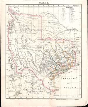
Texas.
sold
- Digital Map Information
- Suitable for large format printing
- Full resolution TIFF file
- ICC color profile embedded
- Delivered instantly via download link
This is a c. 1846 Carl Flemming map of Texas shortly after the Republic of Texas was annexed into the United States (1845). Based on John Arrowsmith's map, Flemming identifies thirty counties in eastern and southeastern Texas, labels them numerically, and provides the county names in a table in the upper right. Numerous settlements are noted along the Rio Grande River in what is today New Mexico. An inset of Galveston Bay is situated in the lower left corner. Flemming also includes an erroneous annotations originally printed on the Arrowsmith map regarding the arid region of western Texas, 'This tract of Country explored by Le Grande in 1833 is naturally fertile, well wooded, and with a fair proportion of water.' (more details)
Western United States just after the Mexican-American War.
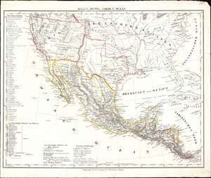
Mexico, Mittel-America, Texas.
sold
- Digital Map Information
- Suitable for large format printing
- DPI: 600
- File Size: 9.33 MB
- File Type: ZIP / TIFF
- ICC color profile embedded
- Delivered instantly via download link
This is a c. 1848 Carl Flemming map of the United States, Mexico, and Central America. Published shortly after the Mexican American War, Flemming highlights the Mexican Cession, acquired by the United States after the Mexican-American War. Texas is also emphasized with borders are at their largest incarnation. (more details)
One of the most detailed 19th century atlas maps of the American West.
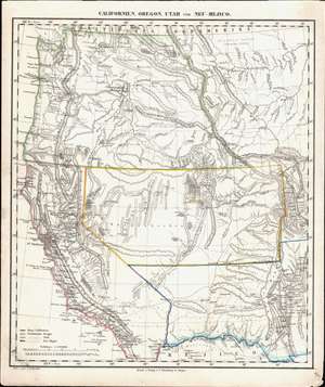
Californien, Oregon, Utah, und Neu-Mejico.
sold
- Digital Map Information
- Suitable for large format printing
- DPI: 600
- File Size: 12.78 MB
- File Type: ZIP / TIFF
- ICC color profile embedded
- Delivered instantly via download link
This is a c. 1850 Carl Flemming map of the western United States during a period of incredible change in the American West. Published soon after California became a state, the map depicts the region from the Pacific Ocean to the Rocky Mountains and from Canada to Mexico. Flemming employs outline color to highlight the State of California and the Oregon, Utah, and New Mexico Territories. Flemming's map is one of the most comprehensive 19th-century atlas maps of this part of the United States. It labels cities and towns and details the region's incredible topography, identifying several mountains in modern-day Colorado while including some fictional mountain ranges in modern-day Nevada. However, the identification of 'Saltlake City or New Jerusalem' in Utah presents the map's most astonishing detail. (more details)
One of the most detailed 19th century atlas maps of the American West.
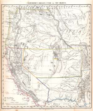
Californien, Oregon, Utah, und Neu-Mejico.
sold
- Digital Map Information
- Suitable for large format printing
- Full resolution TIFF file
- ICC color profile embedded
- Delivered instantly via download link
This is a c. 1850 Carl Flemming map of the western United States during a period of incredible change in the American West. Published soon after California became a state, the map depicts the region from the Pacific Ocean to the Rocky Mountains and from Canada to Mexico. Flemming employs outline color to highlight the State of California and the Oregon, Utah, and New Mexico Territories. Flemming's map is one of the most comprehensive 19th-century atlas maps of this part of the United States. It labels cities and towns and details the region's incredible topography, identifying several mountains in modern-day Colorado while including some fictional mountain ranges in modern-day Nevada. However, the identification of 'Saltlake City or New Jerusalem' in Utah presents the map's most astonishing detail. (more details)
The Height of the Scramble for Africa.
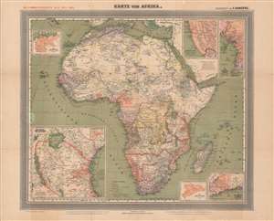
General-Karte von Afrika.
sold
- Digital Map Information
- Suitable for large format printing
- Full resolution TIFF file
- ICC color profile embedded
- Delivered instantly via download link
This is a large-format 1889 German map of Africa from the height of the 'Scramble for Africa' drawn by Friedrich Handtke and published by Carl Flemming. It depicts both European colonies and indigenous kingdoms and confederations, and in particular highlights the recently-established German colonies on the continent. (more details)
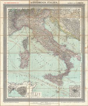
Konigreich Italien.
sold
- Digital Map Information
- Suitable for large format printing
- File Size: 37.2 MB
- File Type: ZIP / TIFF
- ICC color profile embedded
- Delivered instantly via download link
An appealing c. 1890 large format map of Italy issued by Carl Flemming and Friedrich Handtke. The map covers the Italian peninsula in full from the Alps to Sicily, including Malta, Sardinia, Pantelleria, and Corsica. An inset map in the lower left quadrant ... (more details)