
Gastaldi, Giacomo

Giacomo Gastaldi (c. 1500 - October, 1566) was an Italian astronomer, cartographer, and engineer active in the second half of the 16th century. Gastaldi (sometimes referred to as Jacopo or Iacobo) began his career as an engineer, serving the Venetian Republic in that capacity until the fourth decade of the sixteenth century. During this time he traveled extensively, building a large library relating to voyages and exploration. From about 1544 he turned his attention to mapmaking, working extensively with Gextantiovanni Battista Ramusio, Nicolo Bascarini, and Giovanbattista Pedrezano, as well as taking private commissions for, among others, Venice's Council of Ten. He is credited with the fresco maps of Asia and Africa still extant in the map room of the Doge's Palace. Gastaldi was also one of the first cartographers to embrace copper plate over woodblock engraving, marking an important development in the history of cartography. His 1548 edition of Ptolemy's Geographia was the first to be printed in a vernacular; it was the first to be printed in copperplate. As with his Swiss/German contemporary Münster, Gastaldi's work contained many maps depicting newly discovered regions for the first time, including the first map to focus on the East Coast of North America, and the first modern map of the Indian Peninsula. His works provided the source for the vast majority of the Venetian and Roman map publishers of the 1560s and 70s, and would continue to provide an outsize influence on the early maps of Ortelius, De Jode, and Mercator.
Foundational Work in the History of the Atlas.
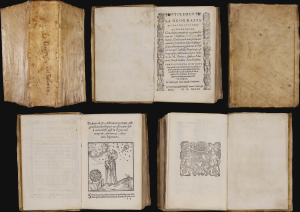
La Geografia, con alcuni comenti e aggiunte fattevi da Sebastiano Munstero, con le tavole non solamente antiche and moderne solite di sta(m)parsi, ma altre nuovo aggiuntevi di Jacopo Gastaldo, ridotta in volgare Italiano da Pietro Andrea Mattiolo.
$42,500.00
Acquire
This is Giacomo Gastaldi's 1548 La Geografia , the first iteration of Ptolemy's foundational ur-atlas to be published in a vernacular. It is the most important proto-atlas to be produced between Martin Waldseemüller's 1513 Ptolemy and Ortelius' 1570 Theatrum. Nordenskiöld hailed it 'the very first atlas of the New World,' citing the work's groundbreaking inclusion of separate maps of the Americas. The work bridges two pillars of Renaissance European geography: the Italian Gastaldi and the German Sebastian Münster. (more details)
One of the Earliest Modern Maps of the Holy Land and Cyprus.
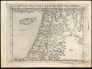
Soria et Terra Santa Nuova Tavola.
$650.00
Acquire
- Digital Map Information
- Suitable for large format printing
- Full resolution TIFF file
- ICC color profile embedded
- Delivered instantly via download link
This is a handsome example of Girolamo Ruscelli's 1561 / 1574 map of the Holy Land and Cyprus. It is an enlarged, more finely-engraved iteration of Giocomo Gastaldi's 1548 Soria e Terra Sancta nova tabula. While Tibbetts avers that the Ruscelli contains fewer place names than its Gastaldi source, he is incorrect: Ruscelli's map preserves all the data of the Gastaldi, but between the increased size of the plate and the clear, legible, and well-spaced engraving of the newer map, its data is presented without the crowding evident on the 1548 map. The skill evident in this work can be credited to the engraver Giulio Sanuto, one of the few Venetian engravers whose career was not isolated either to map engraving or to figurative artistic works, but consisted of both over a career of more than forty years. (more details)
One of the earliest Acquirable Post-Magellan Maps of Southeast Asia.
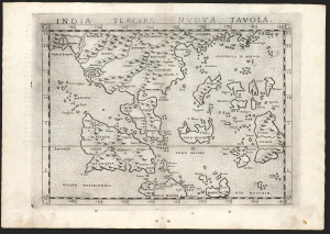
India Tercera Nuova Tavola.
$450.00
Acquire
- Digital Map Information
- Suitable for large format printing
- Full resolution TIFF file
- ICC color profile embedded
- Delivered instantly via download link
This is Girolamo Ruscelli's 1561 / 1574 map of the East Indies and Southeast Asia, considered to be among the earliest maps of Southeast Asia. Although based on Giacomo Gastaldi's 1548 map of the same title, it is roughly twice the size and better engraved. (more details)
One of the Earliest Double-Hemisphere World Maps, Updated.
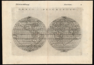
Orbis Descriptio.
$1,400.00
Acquire
- Digital Map Information
- Suitable for large format printing
- Full resolution TIFF file
- ICC color profile embedded
- Delivered instantly via download link
This is a 1598 second-state issue of Girolamo Ruscelli's 1561 map of the world. In its first 1561 state, this is the earliest acquirable double-hemisphere world map, but even this later issue remains one of the earliest acquirable maps to use this format. (more details)
One of the Earliest Modern Maps of Egypt.
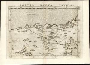
Egitto Nuova Tavola.
$325.00
Acquire
- Digital Map Information
- Suitable for large format printing
- Full resolution TIFF file
- ICC color profile embedded
- Delivered instantly via download link
This is Girolamo Ruscelli's 1561 map of Egypt. It is the second modern map of the Lower Nile, predated only by the 1548 Gastaldi map, upon which it is based. It is among the earliest acquirable maps to show the Nile Delta with contemporaneous information; it is also one of the first printed maps to depict the Egyptian Pyramids. (more details)
One of the Earliest Modern Maps of Italy.
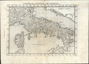
Tavola Nuova d' Italia.
$500.00
Acquire
- Digital Map Information
- Suitable for large format printing
- Full resolution TIFF file
- ICC color profile embedded
- Delivered instantly via download link
An influential 1561 map of Italy by Girolamo Ruscelli, based upon Giacomo Gastaldi's groundbreaking cartography and representing one of the defining maps of Renaissance Italy. Engraved by Giulio Sanuto for Ruscelli's edition of Ptolemy, the map greatly enlarged and refined Gastaldi's seminal 1548 map. From the Alps and Venice to Sicily, it presents Italy with a wealth of cities, mountains, rivers, and coastal detail, enlivened by a dramatically erupting Mount Etna and a miniature view of Venice. Gastaldi's geography, disseminated through Ruscelli's widely read atlas, remained the dominant cartographic representation of Italy until Giovanni Antonio Magini's 1608 map. (more details)
Among the Earliest Acquirable Contemporary Maps of Russia.
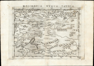
Moschovia Nuova Tavola.
$750.00
Acquire
- Digital Map Information
- Suitable for large format printing
- Full resolution TIFF file
- ICC color profile embedded
- Delivered instantly via download link
This is the 1561 first Ruscelli edition of Giacomo Gastaldi's map of Muscovy, one of the earliest acquirable modern maps of Russia. It is among the earliest obtainable maps to include Paolo Giovio's geography from the Muscovite Embassy. (more details)
Among the Earliest Acquirable Contemporary Maps of the Baltic Coast.
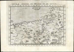
Tavola nuova di Prussia et di Livonia.
$650.00
Acquire
- Digital Map Information
- Suitable for large format printing
- Full resolution TIFF file
- ICC color profile embedded
- Delivered instantly via download link
This is the 1561 first Ruscelli edition of Giacomo Gastaldi's map of the Baltic Coast of Prussia and Livonia, now the coastline of Poland, Lithuania, Latvia, and Estonia. It is among the earliest detailed maps of this part of the world based on contemporary geographical knowledge, particularly with respect to the Gulf of Riga. (more details)
One of the Earliest Maps of Scandinavia, Greenland and Ultima Thule.
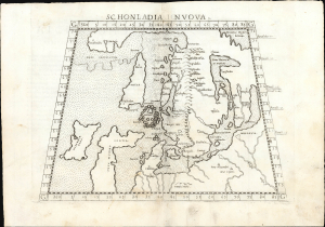
Schonlandia Nuova.
$1,000.00
Acquire
- Digital Map Information
- Suitable for large format printing
- Full resolution TIFF file
- ICC color profile embedded
- Delivered instantly via download link
This is a handsome example of Girolamo Ruscelli's 1561 map of Scandinavia, after Gastaldi. It is among the earliest generally acquirable modern maps of the northern parts of the world, capturing a period when geographers were struggling to integrate new geographical information with heretofore authoritative classical knowledge. Ruscelli's map is an expanded, more clearly-engraved and legible iteration of Gastaldi's 1548 Schonlandia Nova. (more details)
One of the First Acquirable Maps Specifically of Cuba.
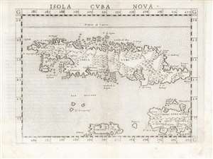
Isola Cuba Nova
$750.00
Acquire
- Digital Map Information
- Suitable for large format printing
- DPI: 600
- File Size: 12.43 MB
- File Type: ZIP / TIFF
- ICC color profile embedded
- Delivered instantly via download link
This is the first state of Girolamo Ruscelli's 1561 map of Cuba, Jamaica, the Cayman Islands, and the western part of Hispaniola. It is among the earliest detailed maps of these islands, and is the fourth printed map specifically of Cuba. (more details)
Northeastern Europe as Known to the Ancients.
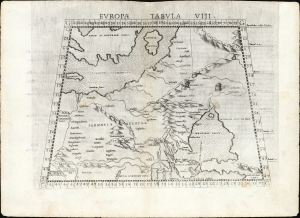
Europa Tabula VIII.
$350.00
Acquire
- Digital Map Information
- Suitable for large format printing
- Full resolution TIFF file
- ICC color profile embedded
- Delivered instantly via download link
This is the 1561 first Ruscelli edition of Ptolemy's map of the lands in Europe occupied in the 1st and 2nd centuries CE by the Sarmatians, a large Iranian confederation who, during the classical era, were pressing from the steppes north of the Black Sea into what would become Russia, Ukraine, Poland, and Hungary. (more details)
One of the First Acquirable Maps Specifically of Hispaniola.
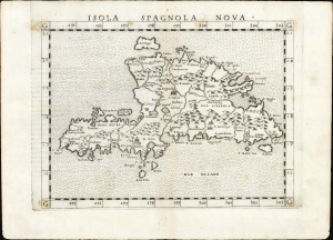
Isola Spagnola Nova.
$550.00
Acquire
- Digital Map Information
- Suitable for large format printing
- Full resolution TIFF file
- ICC color profile embedded
- Delivered instantly via download link
This is the first state of Girolamo Ruscelli's 1561 map of Hispaniola, comprising modern-day Haiti and the Dominican Republic. It is among the earliest detailed maps of the island and is the fourth printed map specifically of it. (more details)
One of the First Acquirable Maps of the North American East Coast in its earliest issue.
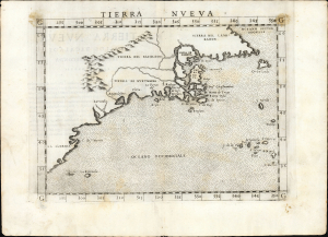
Tierra Nueva.
$2,250.00
Acquire
- Digital Map Information
- Suitable for large format printing
- Full resolution TIFF file
- ICC color profile embedded
- Delivered instantly via download link
This is the first state, first edition, of Girolamo Ruscelli's 1561 map 'Tierra Nueva', an early and influential map of what would become New England and the Canadian Maritime Provinces. It is among the earliest acquirable maps to cover the eastern coastline of North America. The map spans from upper Florida northwards past Cabo de Santa Maria to Larcadia (Kitty Hawk), Angoulesme (New York Harbor), Nova Scotia, and Labrador. The map is a further development of the 1548 Gastaldi map of the same region. While the Gastaldi was limited entirely to the coastline, Ruscelli's map attempted to show a network of rivers and is among the first regional maps to show mountains in the interior of North America. (more details)
Among the earliest detailed maps of the coast of Sub-Saharan Africa.
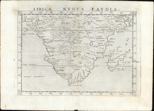
Africa Nuova Tavola.
$500.00
Acquire
- Digital Map Information
- Suitable for large format printing
- Full resolution TIFF file
- ICC color profile embedded
- Delivered instantly via download link
This is Girolamo Ruscelli's 1561 map of southern Africa, an enlarged and improved version of the 1548 map of fellow Venetian Giacomo Gastaldi. It is among the earliest detailed maps of the coast of Sub-Saharan Africa; while Münster's 1540 map presented an image of the whole continent, it lacked significant coastal detail. This map, like its Gastaldi model, is among the earliest obtainable maps to include details of both the African coastline and its river systems. (more details)
One of the Earliest Depictions of Discovery-Era India.
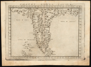
Calecut Nuova Tavola.
$400.00
Acquire
- Digital Map Information
- Suitable for large format printing
- Full resolution TIFF file
- ICC color profile embedded
- Delivered instantly via download link
This is Girolamo Ruscelli's 1561 / 1574 map of India. It is among the earliest printed, modern maps of India - most earlier maps being iterations of Claudius Ptolemy's geographical information of the 2nd century. (more details)
Earliest specific map of Brazil.
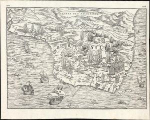
[Brasil].
$2,500.00
Acquire
- Digital Map Information
- Suitable for large format printing
- File Size: 13.62 MB
- File Type: ZIP / TIFF
- ICC color profile embedded
- Delivered instantly via download link
This is Giovanni Battista Ramusio's scarce 1565 map of Brazil, the first printed map to focus specifically on the area. It first appeared in Ramusio's 1556 Navigationi et Viaggi, the first collection of explorers' first-hand accounts of their travels. The woodcut represents the first specific glimpse, in print, of Brazil. While the map's geographical information is frequently credited to Giacomo Gastaldi (1500 - 1566), Ramusio's map is far more likely to have been drawn from his own French sources. (more details)
Capturing a glimpse of Cartier's meeting with the St. Lawrence Iroquois.
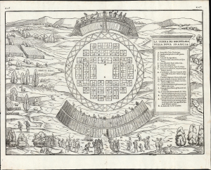
La Terra de Hochelaga Nella Nova Francia.
$4,500.00
Acquire
- Digital Map Information
- Suitable for large format printing
- File Size: 12.67 MB
- File Type: ZIP / TIFF
- ICC color profile embedded
- Delivered instantly via download link
This is an attractive example of the first map of 'Montreal,' in its scarce 1565 second edition. Its first 1556 printing was what Schwartz called 'The very first plan of a village in the United States or Canada,' and it is the earliest printed map to use the place name 'Monte Real,' which would become Montreal. Perhaps even more significantly, this woodcut is one of the only images from the Discovery Period of an intact indigenous town, reflecting its customs. (more details)
First Specific Copperplate Map of Brazil.
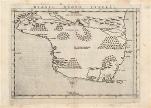
Brasil Nuova Tavola.
$650.00
Acquire
- Digital Map Information
- Suitable for large format printing
- Full resolution TIFF file
- ICC color profile embedded
- Delivered instantly via download link
This is a bold, sharp strike of Girolamo Ruscelli's 1561 map of Brazil. It is among the first detailed specific maps of any part of South America. While most of the maps in Ruscelli's edition of Ptolemy were based on those appearing in Gastaldi's 1548 Ptolemy, this map was a new composition. It is predated only by the Ramusio woodcut map of 1556, whose geography is also credited to Gastaldi, and from which much of the detail of the Ruscelli is derived. (more details)
An Early Map of Western Africa.
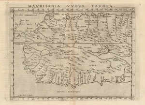
Mauritania Nuova Tavola.
$400.00
Acquire
- Digital Map Information
- Suitable for large format printing
- Full resolution TIFF file
- ICC color profile embedded
- Delivered instantly via download link
This is Girolamo Ruscelli's 1574 map of western Africa, here termed 'Mauritania' but extending south to include northwestern Africa from Gibraltar in the north to the Guinea coast in the south. The map spans from the Canary Islands in the west, eastwards to modern Tunisia and Nigeria. Ruscelli's work is an enlarged and improved version of the 1548 map of fellow Venetian Giacomo Gastaldi. (more details)
One of the First Modern Maps of Poland and Hungary.
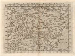
Polonia Et Hungaria Nuova Tavola.
$450.00
Acquire
- Digital Map Information
- Suitable for large format printing
- DPI: 600
- File Size: 11.36 MB
- File Type: ZIP / TIFF
- ICC color profile embedded
- Delivered instantly via download link
This is an attractive example of Girolamo Ruscelli's 1574 modern map of Poland and Hungary. An enlarged version of Giacomo Gastaldi's 1548 map representing what was the state-of-the-art of the mapping of Europe from the Danube to Lithuania, the map depicts as far east as the Black Sea (here named Mar Mazor. Gastaldi's map was a detailed copperplate improvement on Münster's 1540 woodcut map, and would not be improved upon significantly until Ortelius. (more details)
Ortelius' Map of Venice and Apulia.
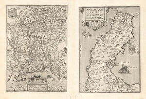
Patavini Territorii Corographia, Iac Castaldo Auct./ Apuliae Quae Olim Iapygia, Nova Corographia. Jacobo Castaldo Auctore.
$500.00
Acquire
- Digital Map Information
- Suitable for large format printing
- DPI: 600
- File Size: 40.49 MB
- File Type: ZIP / TIFF
- ICC color profile embedded
- Delivered instantly via download link
This is Abraham Ortelius' 1573 engraving containing maps of the Italian regions of Padua and Apulia: respectively, the immediate region inland of Venice and the bootheel of Italy. Both maps Ortelius credits to the 16th century Italian doyen of geography, Giocomo Gastaldi; the map illustrates the transmission to the Low Countries of both the traditional medium and the content of 16th century Italian geography. (more details)
Riviera di Genoa.
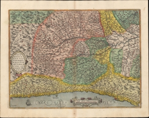
Pedemonta nae Vici Norumque Regionum Auctore Iacabo Castaldo descrip.
$500.00
Acquire
- Digital Map Information
- Suitable for large format printing
- Full resolution TIFF file
- ICC color profile embedded
- Delivered instantly via download link
A beautiful example, in superb original color, of Abraham Ortelius' 1581 map of Piedmont, Italy. Today, this corresponds to the Italian Riviera ('Riviera di Genoa'): Monaco, parts of France, coastal Liguria, and Piedmont. Based on the 1556 cartography of Giacomo Gastaldi, it is considered among the most geographically accurate of Ortelius's regional maps. (more details)
Scarce Miniature Black Sea and Lithuania.
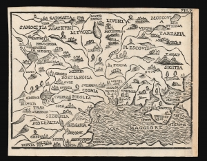
[Untitled map of Eastern Europe].
$400.00
Acquire
- Digital Map Information
- Suitable for large format printing
- DPI: 600
- File Size: 5.34 MB
- File Type: ZIP / TIFF
- ICC color profile embedded
- Delivered instantly via download link
This attractive woodcut map of Lithuania, Ukraine, Bulgaria, Russia, and the Black Sea was executed by Giuseppe Moretti for inclusion in the 1688 edition of Giuseppe Rosaccio's Teatro del Mondo. It is an entertaining composition, embellished with tents indicating Muscovy and Tatary, menacing Lithuania from above the Black Sea. The production of a woodcut map in this period is itself unusual, especially coming from Italy. Venetian and Roman mapmakers had been working on copperplate well before that technology had passed to Antwerp and Amsterdam. (more details)