
Godard, Pierre-François (sold)

Pierre-François Godard (January 21, 1768 - July 22, 1838) was a French woodcut engraver active in Normandy during the late 18th and early 19th centuries. Pierre-François was born in Alençon, Normandy, where his father, Jean Godard (1735 - 1802), was also an engraver, printer, and bookbinder, although self-taught. As a young man he travelled to Nantes where he perfected engraving before returning to Alençon to establish himself as a bookseller and engraver. His earliest engravings date to 1787. He engraved various woodcuts for historical and fictional publications as well as card games for Bree Freres and Étienne de Jouy (1764-1846). Around 1814, citing deteriorating eyesight, Godard stopped engraving, and instead focused on his bookstore. Retiring, Godard sold his bookstore to Auguste-Jean Ruel in 1834. He died 4 years later. His son, Pierre-François Godard, generally known as Godard II d'Alençon (November 8, 1797 - December 15, 1864) was also a wood engraver and followed in the family tradition of bookselling and printing.
Exceptional didactic card game for teaching Astronomy and Geography.
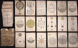
This is an extremely rare complete set of French c. 1807 hand-colored woodcut playing cards prepared as an introductory course on geography and astronomy. The set of 42 cards features a compass rose, an armillary sphere, maps, and more. On the verso of each cards ... (more details)
Didactic cards for Astronomy and Geography.
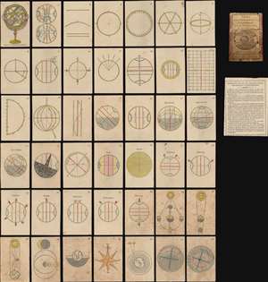
Cartes Elementaires d'Astronomie et de Géographie.
sold
- Digital Map Information
- Suitable for large format printing
- Full resolution TIFF file
- ICC color profile embedded
- Delivered instantly via download link
This is an extremely rare complete set of French c. 1807 hand-colored woodcut playing cards prepared as an introductory course on geography and astronomy - possibly the only surviving fully complete set. The forty-two cards feature a compass rose, an armillary sphere, maps, three volvelles, and more. On the verso of each is explanatory text.
The cards are the work of Louis-Michel Pâris, a French cleric and teacher active in Normandy. He published them as a teaching aid for his secondary school in Argentan. Although the card set is not dated, it was probably printed in 1805 or 1806. We know that Pâris was working on a second edition, which was never published, when he died in 1806. (more details)
The cards are the work of Louis-Michel Pâris, a French cleric and teacher active in Normandy. He published them as a teaching aid for his secondary school in Argentan. Although the card set is not dated, it was probably printed in 1805 or 1806. We know that Pâris was working on a second edition, which was never published, when he died in 1806. (more details)