
Hérisson, Eustache (sold)

Eustache Hérisson (1759 – 1818) was a French cartographer and geographical engineer active in Paris during the early years of the 19th century. Hérisson was a student of the 18th century hydrography Rigobert Bonne. He was a member of the Société Royale. Much of his work was republished posthumously by Bassett, Brue, and others.
Rare First Edition of a Richly Detailed Western Hemisphere Map.
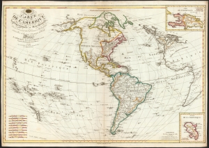
Carte de l'Amérique Septentrionale et Meridionale, ou se trouvent les Decouvertes les plus nouvelles, et les trois Voyages de Cook Dressée Par Hérisson, E lève du C.en Bonne, ancien Ingénieur Hydrographe de la Marine. A Paris, Chez Basset, rue Jacques, au coin de celle des Mathurins, No. 670.
sold
- Digital Map Information
- Suitable for large format printing
- DPI: 600
- File Size: 79.61 MB
- File Type: ZIP / TIFF
- ICC color profile embedded
- Delivered instantly via download link
This is a rare, elegant, and detailed map of America by Eustache Hérisson, in its 1795 first edition. In addition to the Western Hemisphere, Hérisson's work focuses on the three voyages of Captain James Cook - in particular, presenting the key results of his third and final journey to Hawaii, and his efforts to penetrate the Bering Straits. Cook's tracks through the Pacific and the Atlantic both are included. His journey through the South Pacific, its revelations of New Zealand, and the cipher presented by the as-yet undetected Antarctica are also made evident. (more details)
Between revolutions.
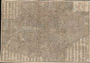
Plan Routier de la Ville et Fauxbourgs de Paris divisé en douze Mairies.
sold
- Digital Map Information
- Suitable for large format printing
- File Size: 48.18 MB
- File Type: ZIP / TIFF
- ICC color profile embedded
- Delivered instantly via download link
This is a striking 1824 Eustache Hérisson city plan or map of Paris, France. Centered on the Ile de la Cité, this map depicts central Paris from the Champ de Mars and the Arc de Triomphe to the Place du Trone (Place de la Nation), and from the Hôpital St. Louis to the Observatoire de Paris. The map illustrates gardens, important buildings, cemeteries, parks, streets, public places, bridges, and twelve districts, or Maries. Surrounding the map is a comprehensive street index. This is the Paris of Victor Hugo, Théodore Rousseau, and Jean-Pierre Dantan. (more details)
The Paris of Victor Hugo and the June Rebellion.
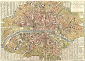
Plan de la Ville et Faubourgs de Paris, Divise en 12 Mairies.
sold
- Digital Map Information
- Suitable for large format printing
- DPI: 300
- File Size: 25.78 MB
- File Type: ZIP / TIFF
- ICC color profile embedded
- Delivered instantly via download link
A stunning large 1833 map of Paris, France, by Eustache Hérisson. Centered on the Ile de la Cité, this map covers central Paris from the Champ de Mars and the Arc de Triomphe to the Place du Trone (Place de la Nation), and from the Abattoir to the Observatoire ... (more details)