
Hyde and Company (sold) (Belcher Hyde Map Company)

Hyde and Company (fl. c. 1880 - 1920) (a.k.a. E. Belcher Hyde Map Company) was a Brooklyn, New York, publisher of maps and atlases. Hyde's work primarily focused on Long Island and the fire insurance industry, which required highly detailed maps of cities and towns in order to assess risk and liability. Many of Hyde's maps offered incredible detail at a large scale, including annotations on property owners, building materials, size, and function. While Long Island was the focus of most of the firm's efforts, it also produced atlases of the greater New York City metropolitan area, including the Bronx, Queens, Manhattan, and Westchester.
AKA: Belcher Hyde Map Company
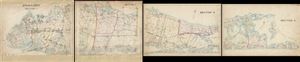
Index Map. [Map of Long Island Based upon Recent U.S. Coast Surveys, Together with Local Maps on File. Supplemented by Careful Territorial Observations].
sold
- Digital Map Information
- Suitable for large format printing
- Full resolution TIFF file
- ICC color profile embedded
- Delivered instantly via download link
This is an index map in four sections depicting the four part 1896 map series by E. Belcher Hyde, detailing Long Island. A set of four sections, the map covers long Island from Brooklyn to Montauk. Section 1 covers from Brooklyn to Westbury, section 2 covers from ... (more details)
Early map of the Hamptons with property owners.
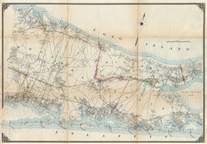
Map of Long Island Based upon Recent U.S. Coast Surveys, Together with Local Maps on File. Supplemented by Careful Territorial Observations. [Suffolk County, Brookhaven, Rivrhead, Southampton].
sold
- Digital Map Information
- Suitable for large format printing
- File Size: 18.79 MB
- File Type: ZIP / TIFF
- ICC color profile embedded
- Delivered instantly via download link
This is the third section of a four part 1896 map series by E. Belcher Hyde, detailing central and eastern Long Island from Ronkonkoma to Matituck and Shinnecock Hills and from Fire Island north to Port Jefferson Harbor including the parts of Suffolk County. The ... (more details)
Early map of Long Island with property owners.
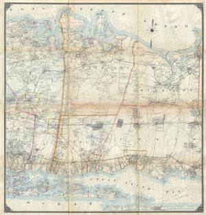
Map of Long Island Based upon Recent U.S. Coast Surveys, Together with Local Maps on File. Supplemented by Careful Territorial Observations. [Nassau County, Suffolk County, Huntington, Islip].
sold
- Digital Map Information
- Suitable for large format printing
- File Size: 35.48 MB
- File Type: ZIP / TIFF
- ICC color profile embedded
- Delivered instantly via download link
This is the central section of a four part 1896 map series by E. Belcher Hyde, detailing central Long Island from Hempstead and Oyster Bay to Islip and Smithtown and from Fire Island north to Lloyd's Neck and Huntington Bay, including the eastern parts of Nassau ... (more details)
Remarkably detailed map of Eastern Long Island including Shelter Island, Montauk, and the Hamptons Resort towns.
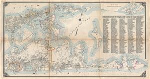
[Shelter Island, Easthampton, Bridgehampton, Sag Harbor, Greenport, Montauk]
sold
- Digital Map Information
- Suitable for large format printing
- File Size: 19.76 MB
- File Type: ZIP / TIFF
- ICC color profile embedded
- Delivered instantly via download link
The eastern section of a four part 1896 map series by E. Belcher Hyde detailing eastern Long Island from Southampton to Montauk and from Cutchogue to Plum Island, including Shelter Island and Sag Harbor. The map details cities throughout and of ten individual ... (more details)
Early map of western Long Island with property owners.
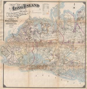
Map of Long Island Based upon Recent U.S. Coast Surveys, Together with Local Maps on File. Supplemented by Careful Territorial Observations. [Brooklyn, Queens, Nassau County].
sold
- Digital Map Information
- Suitable for large format printing
- File Size: 39.89 MB
- File Type: ZIP / TIFF
- ICC color profile embedded
- Delivered instantly via download link
This is a western section of a four part 1896 map series by E. Belcher Hyde, detailing western Long Island from Brooklyn to Hempstead and Freeport and from Glencove south as far as Jones Inlet, including Brooklyn, Queens and Nassau County. The map is highly ... (more details)
Beautiful map of Brooklyn presented on a north-south projection.
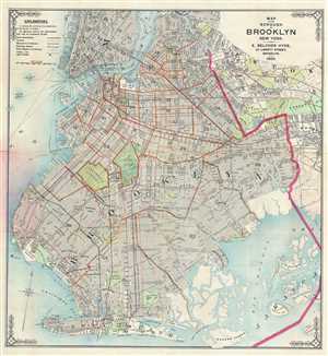
This is an excellent 1905 E. Belcher Hyde map or plan of the borough of Brooklyn, New York. It covers Brooklyn from Jamaica to Bay Ridge and north as far as the Newtown Creek. Includes part of lower Manhattan and Queens. This extremely detailed map ... (more details)
A lovely part of Long Island popular with artists because of its unique light - near the Hamptons.
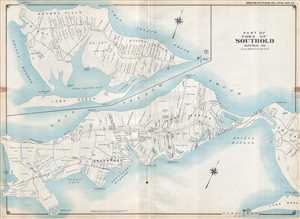
Part of Town of Southold Suffolk Co.
sold
- Digital Map Information
- Suitable for large format printing
- File Size: 22.8 MB
- File Type: ZIP / TIFF
- ICC color profile embedded
- Delivered instantly via download link
This is a 1909 E. Belcher Hyde map of part of the town of Southold located on the North Fork of Long Island in Suffolk County, New York. Often considered a quieter atlernative to the Hamptons in the South Fork, the map depicts the region from ... (more details)
Illustrates in detail the communities of Ocean Beach on Jones Beach Island and Lonelyville on Fire Island.
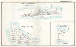
Oak Island Beach. / Muncie Island. / Fire Island Estates (Lonelyville).
sold
- Digital Map Information
- Suitable for large format printing
- File Size: 5.5 MB
- File Type: ZIP / TIFF
- ICC color profile embedded
- Delivered instantly via download link
This is a 1915 E. Belcher Hyde set of three maps of Jones Beach Island and Fire Island, New York, printed on one sheet and depicts the communities of Oak Beach (Oak Island Beach) and Lonelyville (Fire Island Estates – Lonelyville) and Muncie ... (more details)
Illustrates Ocean Beach and Ocean Bay Park on Fire Island in detail - labels homes, businesses, and streets.
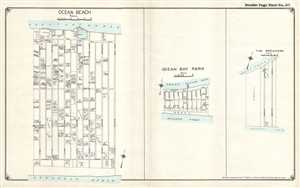
Ocean Beach. / Ocean Bay Park. / The Breakers.
sold
- Digital Map Information
- Suitable for large format printing
- File Size: 4.96 MB
- File Type: ZIP / TIFF
- ICC color profile embedded
- Delivered instantly via download link
This is a 1915 E. Belcher Hyde set of three maps of communities located on Fire Island, New York, printed on one sheet, depicting Ocean Beach, Ocean Bay Park, and The Breakers in their entirety. Each community is presented in detail, with the ... (more details)