
Keeler, William J. (sold)

William J. Keeler (fl. c. 1856 - 1868) was an American civil engineer active during the second half of the 19th century. He is an elusive figure, and little is known of his birth and death dates, places, or early education. He appears in 1856, already working as a civil Engineer in Buffalo with the Erie Canal. In 1862 he received a civilian appointment, and possibly a honorary military rank, to work as an engineer at the Washington Naval Yard. He may also have worked at the Naval Yard in New York (Brooklyn). He was decommissioned in 1864 or 1865, after which he traveled west where he is recorded as an engineer with the Leavenworth, Lawrence and for Gibson Railroad Company. In 1865 he is also mentioned as working with the Union Pacific. In 1866 he was the chief engineer of the Kansas and Nesho Valley Railroad. He appears to have been employed with the department of the Interior Indian Bureau in by 1866 and/or 1867. He released his National Map of The Territory of The United States from the Mississippi River to the Pacific Ocean, one of the most important maps of the American west to appear in the 19th century, 1867. Although based upon government and railroad surveys, the map was a private publication and went through several subsequent editions, reissues, reformatting, and republications. Following the publication of the 2nd edition in 1868, Keeler seems to disappear from all record.
Unrecorded first state of a foundational map with extensive manuscript additions relating to American Indian Reservations established in 1867-8.
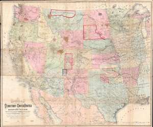
National Map of the Territory of the United States From The Mississippi River To The Pacific Ocean.
sold
- Digital Map Information
- Suitable for large format printing
- Full resolution TIFF file
- ICC color profile embedded
- Delivered instantly via download link
An extraordinary first-edition first-state example of William J. Keeler’s 1867 map of the Trans-Mississippi West - considered the finest post-Civil War railroad era map of the west - with unique manuscript annotations and additions relating to the American Indian Reservation System. This one of a kind historic document was likely the official example retained by the Indian Bureau, and possibly by Keeler himself, to administer and document the development of the American Indian Reservation system through the late 1860s. (more details)
An exceptionally scarce variant of a cornerstone map of the American west and the finest of its era.
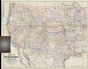
National Map of the Territory of the United States From The Mississippi River To The Pacific Ocean. Madeby the authority of the Hon. O. H. Browning Secretary of the Interior. In the Office of the Indian Bureau Chiefly For Government Purposes under the direction of the Hon. N.G. Taylor, Commisr. of Indian Affairsa and Hon. Chas E. Mix Chief Clerk of the Indian Bureau.
sold
- Digital Map Information
- Suitable for large format printing
- File Size: 46.46 MB
- File Type: ZIP / TIFF
- ICC color profile embedded
- Delivered instantly via download link
A map of the utmost importance and scarcity, this is William J. Keeler's 1868 pocket map of the American west, considered the 'the largest, finest and most detailed map of the West as it was then known.' The map covers from Detroit and Cincinnati westward to the ... (more details)