
Linscott Clarke, Dorothy (sold)

Dorothy Linscott Clarke (April 29, 1903 - May 17, 1992) was an American artist known for her pictorial maps - as such she was one of a series of pioneering women cartographers active in the pictorial map genre. She lived in Hampton, Maine, with her husband, the advertising consultant Charles C. Clarke (???? - 1969). Her earliest known work is a 1930 pictorial map of Noah's Ark, followed by the 1939 Historical Picture Map of Vermont, which is rare enough that we have never seen an example. She later lived in Sudbury or Shrewsbury, Massachusetts. She created pictorial maps of Vermont and Worcester County, Massachusetts, along with fantasy maps of subjects including Mother Goose.
A charming pictorial map of animals disembarking from Noah's Ark. Perfect for a child's bedroom!
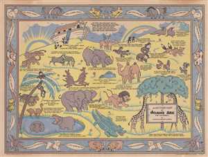
A Picture Map of Noah's Ark for Children.
sold
- Digital Map Information
- Suitable for large format printing
- File Size: 7.11 MB
- File Type: ZIP / TIFF
- ICC color profile embedded
- Delivered instantly via download link
This is a c. 1930s pictorial children's map of the Noah's Ark bible story. The map illustrates the end of the story, after Noah saves a pair of every species of animal and sails in an ark for forty days and nights. Noah can be seen waving goodbye to all of his ... (more details)
The Land of Mother Goose's characters and nursery rhymes.
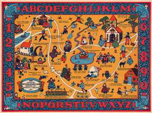
A Map of Mother Goose Land.
sold
- Digital Map Information
- Suitable for large format printing
- File Size: 54.74 MB
- File Type: ZIP / TIFF
- ICC color profile embedded
- Delivered instantly via download link
This is a 1933 Dorothy Linscott pictorial map of Mother Goose Land. Populated by characters from Mother Goose nursery rhymes, Little Jack Horner, Jack and Jill, the Old Woman Who Lived in a Shoe, Little Miss Muffet, and Mary and her Little Lamb all make appearances. Other rhymes that are referenced include 'Ring Around a Rosies', 'Hickory Dickory Dock', and 'Rock-a-bye Baby'. The ABCs and the numbers up to ten occupy the pictorial border and four more rhymes appear in the corners. (more details)
A rare pictorial map of New Hampshire's seacoast, the birthplace of the U.S. Navy.
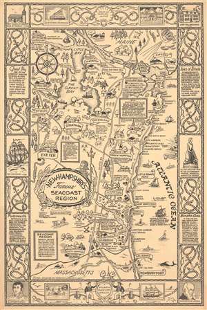
This 1964 Dorothy Linscott Clarke pictorial map of New Hampshire's seacoast region celebrates its nautical heritage. Portsmouth, the area's cultural and commercial center, is remembered as the 'birthplace of the U.S. Navy' during the American Revolution. Clarke uses this to her advantage, employing a ship's wheel as the compass rose and adorning the title cartouche with Poseidon, seaweed, and seashells. Several ships ply the waters of the Atlantic and the Great Bay, one of the largest sheltered bays along the Atlantic coast. This map also highlights the commercial and recreational aspects of this thirteen-mile stretch of the Atlantic coast. Beachgoers enjoying themselves in bathing suits and umbrellas dot the coastline around Hampton Beach and Hampton Harbor. Banners and illustrations of buildings mark towns and villages, including Portsmouth, Durham, Exeter, Rye, Hampton, and Greenland. Textboxes provide short histories of Rye and Exeter, and the founding dates of other towns are noted. The region's landmarks, such as the Weeks House in Greenland and Exeter Academy in Exeter, are referenced. The whole is surrounded by a nautical-themed pictorial border, where illustrations of ropes and anchors separate text boxes filled with historical information, views of historic buildings and ships, and portraits of important historical figures. (more details)
Seacoast New Hampshire.
This 1964 Dorothy Linscott Clarke pictorial map of New Hampshire's seacoast region celebrates its nautical heritage. Portsmouth, the area's cultural and commercial center, is remembered as the 'birthplace of the U.S. Navy' during the American Revolution. Clarke uses this to her advantage, employing a ship's wheel as the compass rose and adorning the title cartouche with Poseidon, seaweed, and seashells. Several ships ply the waters of the Atlantic and the Great Bay, one of the largest sheltered bays along the Atlantic coast. This map also highlights the commercial and recreational aspects of this thirteen-mile stretch of the Atlantic coast. Beachgoers enjoying themselves and umbrellas dot the coastline around Hampton Beach and Hampton Harbor. Banners and illustrations of buildings mark towns and villages, including Portsmouth, Durham, Exeter, Rye, Hampton, and Greenland. Textboxes provide short histories of Rye and Exeter, and the founding dates of other towns are noted. The region's landmarks, such as the Weeks House in Greenland and Exeter Academy in Exeter, are referenced. The whole is surrounded by a nautical-themed pictorial border, where illustrations of ropes and anchors separate text boxes filled with historical information, views of historic buildings and ships, and portraits of important historical figures. (more details)