
Pagano, Matteo (sold)

Matteo Pagano (1515-1588) was a Venetian woodcut artist and illustrator. While nothing is known about his early training, he was prolific and apparently successful. Among his more famous works is a 1556 eight-sheet woodcut of the procession of the Doge, in Venice. He produced a number of maps for various works, most notably the visually distinctive area maps appearing in Ramusio's Navigazioni et Viaggi. He is particularly noted for having published books of lace, needlework and embroidery designs, promoting needlework as an acceptable activity for virtuous women.
Most beautiful early woodcut of Hispaniola.
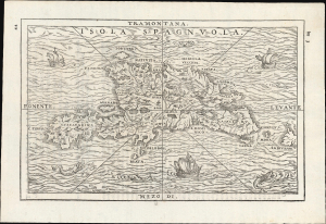
Isola Spagnuola.
sold
- Digital Map Information
- Suitable for large format printing
- File Size: 5.94 MB
- File Type: ZIP / TIFF
- ICC color profile embedded
- Delivered instantly via download link
This scarce 1565 woodcut map of Hispaniola, published in Giovanni Battista Ramusio's Navigationi et Viaggi, is the most attractive of the early depictions of the island. As with the 1556 first block of the map, it is geographically based on the 1534 Peter Martyr map of the island. But whereas the 1556 edition was a rote copy of the unadorned 1534 map, this 1565 second block is a beautiful example of the art of the woodcut, embellishing the waters around the island with waves, ships, and sea monsters, while the land is evocatively rendered with mountains and pictorial cities far beyond those presented in the earlier edition. (more details)
'An advance of the first importance' - Wheat
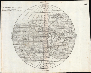
Universale Della Parte De Mondo Nuovamente Ritrovata.
sold
- Digital Map Information
- Suitable for large format printing
- File Size: 10.16 MB
- File Type: ZIP / TIFF
- ICC color profile embedded
- Delivered instantly via download link
This is Giovanni Battista Ramusio's scarce 1556 map of the Americas. It appeared in Ramusio's Navigationi et Viaggi, the first collection of explorers' first-hand accounts of their travels. It is among the earliest detailed representations of the Western Hemisphere, and was the first overall printed map of America to include placenames from Coronado's travels of 1540-1542. Wheat hailed this inclusion as an advance of the first importance, so far as the mapping of the American West is concerned. (more details)
The first state of the earliest specific map of Brazil.
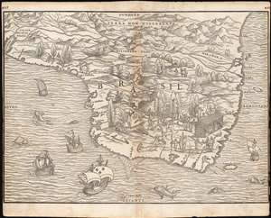
[Brasil].
sold
- Digital Map Information
- Suitable for large format printing
- Full resolution TIFF file
- ICC color profile embedded
- Delivered instantly via download link
This is the seminal, rare 1556 Giovanni Battista Ramusio map of Brazil, the first printed map to focus specifically on the area. It appeared in Ramusio's 1556 Navigationi et Viaggi, the first collection of explorers' first-hand accounts of their travels. The woodcut represents the first glimpse in print specifically of Brazil. The geographical information is generally credited to Giocomo Gastaldi (1500 - 1566). Much of that detail, and all of the socio-ethno-economic imagery of the map appears to have been drawn either from the 1519 manuscript Lopo Homem (1497 - 1572) Carta do Brasil, or from one or another manuscript of the Dieppe school. This is significant. An overwhelming percentage of maps of South America in the 16th century, printed and manuscript, carry either imagery or text describing the indigenous population as savages and cannibals. Of the early printed maps of Brazil, this is the only to highlight instead the harvesting of the lumber, which represented the initial economic draw for Europeans: Brazil wood, which when harvested and processed produced a highly desirable dye. Not only are the natives shown harvesting trees, and hauling them to the shore - they are also shown with parrots and monkeys, also desirable trade items. More significantly, the map shows a native exchanging lumber for a cup, given by men in European garb. This is one of the only printed maps to depict the active trade which had been underway for decades between French mariners from Normandy and the Tupi peoples of Brazil. Ramusio, as Venetian ambassador to France, may well have had access to French manuscript maps of the Dieppe school (which Surekha Davies notes were remarkable for their depiction of Brazilian indigenes as trade partners rather than predators.) The ships shown sailing the Atlantic here tell a related story: The Portuguese enjoyed a Papally decreed monopoly on the exploitation and colonization of Brazil under the 1494 Treaty of Tordesillas. French / Norman trade with Brazilian natives was done in defiance of the Portuguese, frequently meeting armed resistance. Of the five ships on this map, the smaller three sport the arms of Portugal. The two larger ships in the foreground bear the French fleurs-de-lis. This is a common thread appearing on Ramusio's maps: the notion that whatever the Portuguese have found around the world, the French ought to be able to take. (more details)
First Map to show New York Harbor. The First Map to name Canada.
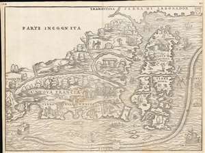
La Nuova Francia.
sold
- Digital Map Information
- Suitable for large format printing
- Full resolution TIFF file
- ICC color profile embedded
- Delivered instantly via download link
This is the seminal 1556 Giovanni Battista Ramusio map of the Northeast and Canada, 'the first printed map devoted to the New England region' (Osher), and the first map to apply a specific name to Canada. The map depicts the northeastern coast of North America from New York to the coast of Labrador, inclusive of New England and maritime Canada. It is the first map to reveal Giovanni da Verrazano's 1524 voyage to America and to depict his discoveries in what would become New York and New England. It is also among the most visually engaging early maps, being richly decorated with depictions of indigenous peoples, Europeans, flora and fauna, sailing ships, sea monsters, and demons. (more details)
'An advance of the first importance' - Wheat
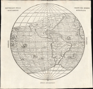
Universale Della Parte De Mondo Nuovamente Ritrovata.
sold
- Digital Map Information
- Suitable for large format printing
- File Size: 7.62 MB
- File Type: ZIP / TIFF
- ICC color profile embedded
- Delivered instantly via download link
This is Giovanni Battista Ramusio's scarce 1565 map of the Americas. It first appeared in Ramusio's 1556 Navigationi et Viaggi, the first collection of explorers' first-hand accounts of their travels. It is among the earliest detailed representations of the Western Hemisphere, predated only by the 1540 Münster and the extremely rare 1554 Bellère map. This was the first printed map of America to include placenames from Coronado's travels of 1540-1542: Wheat hailed this inclusion as 'an advance of the first importance, so far as the mapping of the American West is concerned.'
Ramusio commissioned Giacomo Gastaldi (1500 - 1566) to compose this map, along with the others appearing in the Navigationi et Viaggi; that much of its detail agrees with the western portion of Gastaldi's 1546 world map supports this. (more details)
Ramusio commissioned Giacomo Gastaldi (1500 - 1566) to compose this map, along with the others appearing in the Navigationi et Viaggi; that much of its detail agrees with the western portion of Gastaldi's 1546 world map supports this. (more details)
Earliest specific map of Brazil.
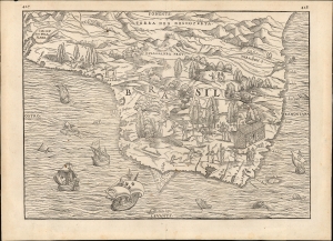
[Brasil].
sold
- Digital Map Information
- Suitable for large format printing
- File Size: 12.38 MB
- File Type: ZIP / TIFF
- ICC color profile embedded
- Delivered instantly via download link
This Giovanni Battista Ramusio's scarce 1565 map of Brazil, the first printed map to focus specifically on the area. It first appeared in Ramusio's 1556 Navigationi et Viaggi, the first collection of explorers' first-hand accounts of their travels. The woodcut represents the first glimpse in print specifically of Brazil. The geographical information is generally credited to Giocomo Gastaldi (1500 - 1566). Much of that detail, and all of the socio-ethno-economic imagery of the map appears to have been drawn either from the 1519 manuscript Lopo Homem (1497 - 1572) Carta do Brasil, or from one or another manuscript of the Dieppe school. This is significant. An overwhelming percentage of maps of South America in the 16th century, printed and manuscript, carry either imagery or text describing the indigenous population as savages and cannibals. Of the early printed maps of Brazil, this is the only to highlight instead the harvesting of the lumber, which represented the initial economic draw for Europeans: Brazil wood, which when harvested and processed produced a highly desirable dye. Not only are the natives shown harvesting trees and hauling them to the shore - they are also shown with parrots and monkeys, also desirable trade items. More significantly, the map shows a native exchanging lumber for a cup, given by men in European garb. This is one of the only printed maps to depict the active trade which had been underway for decades between French mariners from Normandy and the Tupi peoples of Brazil. Ramusio, as Venetian ambassador to France, may well have had access to French manuscript maps of the Dieppe school (which Surekha Davies notes were remarkable for their depiction of Brazilian indigenes as trade partners rather than predators.) The ships shown sailing the Atlantic here tell a related story: The Portuguese enjoyed a Papally decreed monopoly on the exploitation and colonization of Brazil under the 1494 Treaty of Tordesillas. French / Norman trade with Brazilian natives was done in defiance of the Portuguese, frequently meeting armed resistance. Of the five ships on this map, the smaller three sport the arms of Portugal. The two larger ships in the foreground bear the French fleurs-de-lis. This is a common thread appearing on Ramusio's maps: the notion that whatever the Portuguese have found around the world, the French ought to be able to take. (more details)
Capturing a glimpse of Cartier's meeting with the St. Lawrence Iroquois.
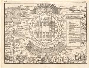
La Terra de Hochelaga Nella Nova Francia
sold
- Digital Map Information
- Suitable for large format printing
- DPI: 600
- File Size: 11.86 MB
- File Type: ZIP / TIFF
- ICC color profile embedded
- Delivered instantly via download link
This is an attractive example of the scarce first map of 'Montreal.' Printed in 1565, it is what Schwartz calls 'The very first plan of a village in the United States or Canada,' and it is the earliest printed map to use the place name 'Monte Real,' which would become Montreal. Perhaps even more significantly, this woodcut is one of the only images from the Discovery Period of an intact indigenous town, and its customs. (more details)
Capturing a glimpse of Cartier's meeting with the St. Lawrence Iroquois.
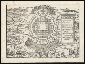
La Terra de Hochelaga Nella Nova Francia.
sold
- Digital Map Information
- Suitable for large format printing
- File Size: 13.66 MB
- File Type: ZIP / TIFF
- ICC color profile embedded
- Delivered instantly via download link
This is an attractive example of the first map of 'Montreal,' in its scarce 1565 second edition. Its first 1556 printing was what Schwartz called 'The very first plan of a village in the United States or Canada,' and it is the earliest printed map to use the place name 'Monte Real,' which would become Montreal. Perhaps even more significantly, this woodcut is one of the only images from the Discovery Period of an intact indigenous town, reflecting its customs. (more details)
First Map to detail New York Harbor; the First Map to name Canada.
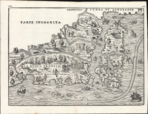
La Nuova Francia.
sold
- Digital Map Information
- Suitable for large format printing
- File Size: 13.96 MB
- File Type: ZIP / TIFF
- ICC color profile embedded
- Delivered instantly via download link
This is a superb example of the seminal 1565 Giovanni Battista Ramusio map of the Northeast and Canada, The first printed map devoted to the New England region (Osher) and the first map to apply a specific name to Canada. Significantly, it is the first map to focus specifically on Giovanni da Verrazzano's 1524 discoveries in what would become New York and New England - making it the first map to depict New York Bay and Harbor. (more details)
The First Map to show New York Harbor; the First Map to name Canada.
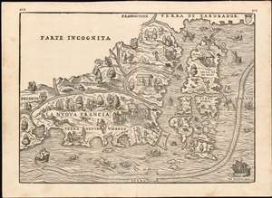
La Nuova Francia.
sold
- Digital Map Information
- Suitable for large format printing
- DPI: 600
- File Size: 14.84 MB
- File Type: ZIP / TIFF
- ICC color profile embedded
- Delivered instantly via download link
This is the seminal 1565 Giovanni Battista Ramusio map of the Northeast and Canada, 'The first printed map devoted to the New England region'(Osher) and the first map to apply a specific name to Canada. The map depicts the northeastern coast of North America from New York to the coast of Labrador, inclusive of New England and maritime Canada. In particular, it is the first map to reveal Giovanni da Verrazano's 1524 voyage to America and to depict his discoveries in what would become New York and New England. It is also among the most visually engaging early maps, being richly decorated with depictions of indigenous peoples, Europeans, flora and fauna, sailing ships, sea monsters, and demons. (more details)
Scarce, Prague-engraved map of Crete.
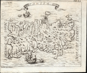
Candia.
sold
- Digital Map Information
- Suitable for large format printing
- File Size: 2.8 MB
- File Type: ZIP / TIFF
- ICC color profile embedded
- Delivered instantly via download link
This is a 1732 map of Crete, appearing in the printed pilgrimage of the Bohemian monk and traveler Angelikus Maria Müller. This north-oriented map illustrates the island's topography pictorially and dramatically. The map is strikingly engraved and embellished with fine ships. (more details)