
Phillips, Luther Savage (sold)

Luther Savage Phillips (May 10, 1891 - 1960) was an American map maker, photographer, architect, and postcard publisher, and is arguably Maine's most significant pictorial cartographer. Born on Mount Desert Island (Acadia National Park), Maine, Phillips studied at Phillips Andover Academy before spending two years at Yale. He graduated with a Bachelor of Science degree from MIT in 1914. In October 1917 Phillips enlisted in the U.S. Navy as a Coxswain and was commissioned as an Ensign in 1918, when he was sent to the U.S. Naval Academy at Annapolis, Maryland. He was later assigned to the U.S.S. Rhode Island and sailed with the ship on a mission to Archangel on April 11, 1919. After his time in the Navy, Phillips established a successful postcard publishing business and became a well-known pictorial mapmaker. Much of his work focused on the Maine coast in the vicinity of Bar Harbor. Based in Northeast Harbor, Mount Desert Island, Maine, his company, 'Map of Maine' produced local pictorial maps for the tourist market. He would tour the state promoting and selling his work, along with his scenic postcards. After Phillips died in 1960, in Togus, Maine, his brother, Augustus 'Gus' Dewey Phillips (1898 - 1975) took over the map and postcard business, which was then continued by his nephew Donald Phillips (1935 - 2009). In a tragic turn of events, in 1973 an out of control bush fire destroyed the Phillips studio and much of the surviving stock, making all Phillips' maps issued prior to that date rare. Philipps married Olympia Meimari on March 24, 1921 in Annapolis. It is unclear whether Olympia died or the couple divorced, but it is known that Phillips remarried, to Mary J. Merrill in 1935.
Scarce map of Mount Desert Island by Maine's most notable maker of pictorial maps.
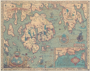
This high decorative 1832 pictorial map of Mount Desert Island, and vicinity, was drawn and published by Luther S. Phillips. The map covers the main coast from Surry to Dyer Neck, including Mount Desert Island, Long Island, Bartlett Island, Gouldsboro, Winter ... (more details)
Acadia National Park by a Northeast Harbor local.
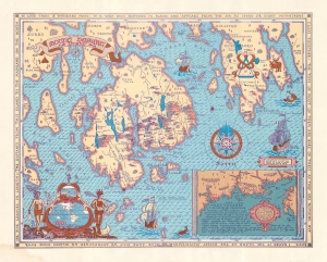
This is a scarce 1932 pictorial map of Mount Desert Island and its vicinity, drawn and published by Northeast Harbor artist Luther S. Phillips. The map includes Acadia National Park, the largest and most beloved national park in the eastern United States. (more details)
Pictorial map of the Penobscot Bay region of Maine.
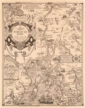
A Decorative Map of Penobscot Bay Region Showing the tidal coast of Maine from Camden to Blue Hill and Isles boro to Bangor.
sold
This is a 1940 Luther Savage Phillips pictorial map of Penobscot Bay, Maine. The map depicts the region from Hobbs Pond and Camp Merestead to Blue Hill Bay and from Bangor to Deer Isle. Sites throughout the region are illustrated in profile with their names inscribed on banners, including the Penobscot Marine Museum, the St. Regis Paper Company, Sunset Ridge Farm, Camp Roosevelt, and the Walter M. Hardy Orchard. Other regional sites are also identified, as are important highways, rivers, and islands. An inset to the right of center illustrates Fort Pownal and is situated next to a textbox that provides a short history of Penobscot Bay which reads, ‘Discovered by Gomes in 1525 and named by him ‘Baya Fermosa’ (beautiful bay), the Penobscot - generally associated with the region of Norumbega - has appeared prominently on old charts of North America.’ A short chronological history of the region is included as well, along the top border, near an inset map of 'Part of Bangor and Brewer', while a second insert, in the lower left quadrant, details the city of Belfast. Three sailing ships are depicted in Penobscot Bay, along with a lone sea monster. (more details)
First edition pictorial map Mount Desert Island.
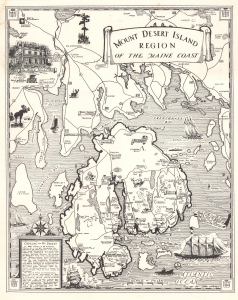
This is a rare first edition 1941 Luther S. Phillips pictorial map of Mount Desert Island, Maine. It highlights one of the most popular tourist destinations on the eastern seaboard - Acadia National Park. Philips' maps have been popular since their inception, and variations are still published today, but first editions, as here, are special and scarce. (more details)
First edition pictorial map Mount Desert Island.
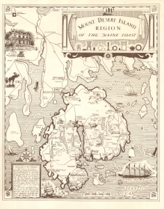
This is a rare first-edition 1941 Luther S. Phillips pictorial map of Mount Desert Island, Maine. It highlights one of the most popular tourist destinations on the eastern seaboard - Acadia National Park. Phillips was a local of Mount Desert Island, living most of his life in Northeast Harbor. His fun pictorial maps were popular with tourists and locals, enjoying a wide following. First editions of his works, as here, are now very scarce. (more details)
Pictorial map of Moosehead Lake.
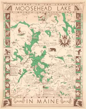
This is a 1953 Luther S. Phillips pictorial map of Moosehead Lake, Maine. Moosehead Lake dominates, with coves, bays, and the larger islands illustrated and labeled. Depth soundings (in feet) are indicated throughout. Towns around the lake, including Rockwood and Greenville, are identified by banners. Two scrolls, one along the left border and the other along the bottom border, numerically identify locations within Rockwood and Greenville, all of which are also marked on the map. Camps, inns, and other locations are identified along the banks of Moosehead Lake as well as in other parts of the region. Pictorial vignettes highlight outdoor activities popular in the region, such as fishing and canoeing, as well as the area's wildlife, including deer and black bear. A moose head adorns the compass rose situated near the right border. Illustrations of the leaves of some trees native to the region create a charming pictorial border, with illustrations of fish, geese, and moose appearing as well. (more details)
Interesting pictorial map of Acadia National Park, Mount Desert Island, and Frenchman's Bay.

Sunrise on Acadia This National Park Established in 1919.
sold
- Digital Map Information
- Suitable for large format printing
- File Size: 15.56 MB
- File Type: ZIP / TIFF
- ICC color profile embedded
- Delivered instantly via download link
A very attractive 1966 pictorial map of Mount Desert Island, Frenchman bay, and the Schoodic Peninsula. The map was drawn by Augustus D. Phillips, a Northeast Harbor native, in memory of George B. Dorr, Charles, W. Eliot, and John D. Rockefeller Jr. who ... (more details)
Highlights historic houses throughout the county.
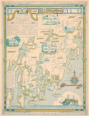
Wiscasset. Damariscotta. Newcastle. Edgecomb. Southport. Boothbay Harbor. Boothbay. Bristol. South Bristol. Waldoboro.
sold
This is a 1966 Augustus Dewey Phillips pictorial map of Lincoln, County, Maine. Depicting from Montsweag Bay to Muscongus Bay and from Waldoboro to Cape Island, Dewey highlights local history, the county's historic whaling towns, and identifies many local businesses. The towns of Damariscotta, Waldoboro, Wiscasset, Boothbay Harbor, Newcastle, Boothbay, and others all appear. Vignettes illustrate important historic structures, including the Marie Antoinette House in North Edgecomb, Castle Tucker, the Stetson House in Damariscotta, the Boothbay Railway Museum, and the Kavanagh House in Damariscotta Mills. The Round Top Dairy, Cable's Gifts, the Rock Schoolhouse, Emerson's Smorgasbord, the Boothbay Golf Club, and the Bayside Oaks Snack Bar represent a sampling of the local establishments from across the county promoted by Phillips. A text along the left border provides a short history of Lincoln County's founding. (more details)
Historic homes!
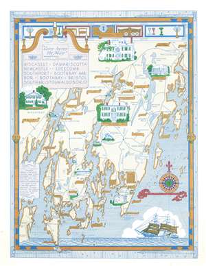
Wiscasset. Damariscotta. Newcastle. Edgecomb. Southport. Boothbay Harbor. Boothbay. Bristol. South Bristol. Waldoboro.
sold
This is a 1966 Augustus Dewey Phillips pictorial map of Lincoln, County, Maine depicting from Montsweag Bay to Muscongus Bay and from Waldoboro to Cape Island. Phillips highlights local history, the county's historic whaling towns, and identifies many local businesses. The towns of Damariscotta, Waldoboro, Wiscasset, Boothbay Harbor, Newcastle, Boothbay, and others appear. Vignettes illustrate important historic structures, including the Marie Antoinette House in North Edgecomb, Castle Tucker, the Stetson House in Damariscotta, the Boothbay Railway Museum, and the Kavanagh House in Damariscotta Mills. The Round Top Dairy, Cable's Gifts, the Rock Schoolhouse, Emerson's Smorgasbord, the Boothbay Golf Club, and the Bayside Oaks Snack Bar represent a sampling of the local establishments. A text along the left provides a short history of Lincoln County's founding. (more details)
Pictorial map of Maine.
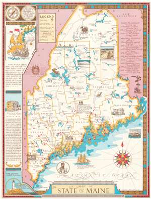
This is a 1980 A. D. Phillips and Son pictorial map of Maine. Pictorial vignettes highlight the Kavanagh House in Damariscotta Mills, the John Holmes House in Alfred, and the Ruggles House in Columbia Falls. Maine's wildlife also takes center stage, with illustrations of a moose, a deer, and a black bear. Mount Desert Island is beautifully illustrated. Maine's many ski areas are marked by skier icons, while red dots identify golf courses. Red flags note yacht clubs and red triangles identify large and small marinas. A poem appears in the upper left corner, while a list of early explorers of Maine occupies the left border. (more details)