
Prévost d'Exiles, Antoine François (Abbe Provost)
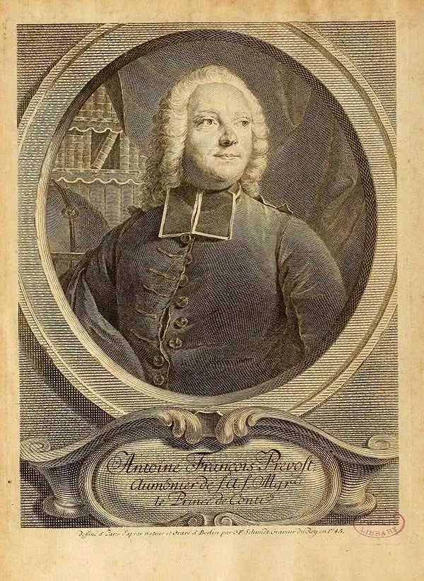
Antoine François Prévost d'Exiles (April 1, 1697 – November 25, 1763), usually known the Abbé Prévost, was a French author and novelist. Having had difficulty in his youth determining a preference for life in the military or life among the Jesuits, he eventually wound up with the Benedictines, with whom he took vows. Despite his taking the vows, the vows evidently did not take with him: in 1728 he abandoned his abbey and fled to London. Naturally, he became a writer. In this he was prolific, both producing his own work and translations of others. Beginning in 1726, he published the first volume of his Histoire générale des voyages, which he worked on for the remained of his life and which was completed by his associates after his death, stretching to 25 volumes.
AKA: Abbe Provost
Attractive French Map of the Northern Extremities of Russia.
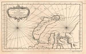
Partie de la Mer Glaciale, Contenant La Nouvelle Zemble et le Pais de Samoiedes suivant les Découvertes des Hollandois et les Cartes des Russes Pour servir à l'Histoire Générale des Voyages Par M. Bellin Ing. de la Marine 1758.
$250.00
Acquire
- Digital Map Information
- Suitable for large format printing
- Full resolution TIFF file
- ICC color profile embedded
- Delivered instantly via download link
This is a 1758 Bellin map of the northwestern coast of Russia, focusing on the island of Nova Zembla, the mouth of the River Ob, and the limits of European efforts to achieve a northeast passage. The eastern shore of Nova Zembla is sketched in and noted to be entirely unknown; The Kara sea is not named, but it is accurately described as a gulf 'nearly always full of ice.' The site of Barentz's famous refuge in the north of Nova Zembla is marked Ici les Hollandois basserent l'hiver en 1596. The Ob and the Yenisea rivers are shown with reasonable accuracy, but beyond the mouth of the unnamed Pyasina River, the coastline is conjectural and, again, n'est pas connue.
Despite its appearance in Prévost's Histoire générale des voyages - a work perhaps better known for its imaginative flourish than its factuality - Bellin drew on state-of-the-art knowledge for the maps he contributed. Though the map was intended to contextualize Prévost's discussion of Russia's indigenous tributaries to the Tsars, Bellin's map presents a reasonably accurate depiction of what western Europeans understood of the geography of this remote region. (more details)
Despite its appearance in Prévost's Histoire générale des voyages - a work perhaps better known for its imaginative flourish than its factuality - Bellin drew on state-of-the-art knowledge for the maps he contributed. Though the map was intended to contextualize Prévost's discussion of Russia's indigenous tributaries to the Tsars, Bellin's map presents a reasonably accurate depiction of what western Europeans understood of the geography of this remote region. (more details)
Attractive French Map of the Northern Extremities of Russia.
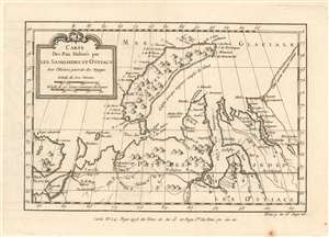
Carte Des Pais Habités par Les Samojedes et Ostiacs Pour l'Histoire Générale des Voyages.
$175.00
Acquire
- Digital Map Information
- Suitable for large format printing
- DPI: 600
- File Size: 4.32 MB
- File Type: ZIP / TIFF
- ICC color profile embedded
- Delivered instantly via download link
This is a 1749 Bellin map of the northwestern coast of Russia, focusing on the island of Nova Zembla, the mouth of the River Ob, and the limits of European efforts to achieve a northeast passage. The eastern shore of Nova Zembla is sketched in and noted to be entirely unknown; The Kara sea is not named, but it is described as a gulf 'nearly always full of ice.' The Ob and the Yenisea rivers are shown with reasonable accuracy, but beyond the mouth of the unnamed Pyasina River, the coastline is conjectural and, again, n'est pas connue.
Despite its appearance in Prévost's Histoire générale des voyages - a work perhaps better known for its imaginative flourish than for its factuality - Bellin drew on state-of-the-art knowledge for the maps he contributed. Though the map was intended to contextualize Prévost's discussion of Russias indigenous tributaries to the Tsars, Bellin's map presents a reasonably accurate depiction of what Europeans understood of the geography of this remote region. (more details)
Despite its appearance in Prévost's Histoire générale des voyages - a work perhaps better known for its imaginative flourish than for its factuality - Bellin drew on state-of-the-art knowledge for the maps he contributed. Though the map was intended to contextualize Prévost's discussion of Russias indigenous tributaries to the Tsars, Bellin's map presents a reasonably accurate depiction of what Europeans understood of the geography of this remote region. (more details)
Mapping the Transatlantic Slave Trade.
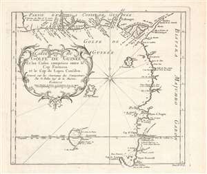
Carte du golfe de Guinée et les costes comprises entre le cap Formosa et le cap de Lopes Goncalvo.
$200.00
Acquire
- Digital Map Information
- Suitable for large format printing
- DPI: 600
- File Size: 17.75 MB
- File Type: ZIP / TIFF
- ICC color profile embedded
- Delivered instantly via download link
This is a c. 1754 map and chart of the Gulf of Guinea by Jacques-Nicolas Bellin that appeared in the Abbé Prévost's Histoire Generale Des Voyages. It notes a range of maritime and terrestrial features, especially rivers flowing from the African interior into the gulf. (more details)
Early 18th century map or plan of Boston, Massachusetts.
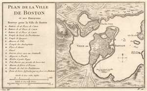
Plan de la Ville de Boston et ses Environs.
$500.00
Acquire
- Digital Map Information
- Suitable for large format printing
- DPI: 600
- File Size: 9.06 MB
- File Type: ZIP / TIFF
- ICC color profile embedded
- Delivered instantly via download link
This is a striking 1757 Jacques-Nicolas Bellin map of Boston, Massachusetts. Coverage embraces the Shawmut Peninsula of Boston with nearby Charestown across the harbor. The isle ronde is situated along the right side with a windmill (moulin) labeled. An artillery battery protects the road into Charles Town. Sixteen locations around Boston are marked alphabetically and correspond with an index to the left. Among the locations notes are churches, three artillery batteries, and the powder magazine. Just three depth soundings are noted in Boston Harbor. (more details)
One of the Earliest Obtainable Maps of Taiwan.
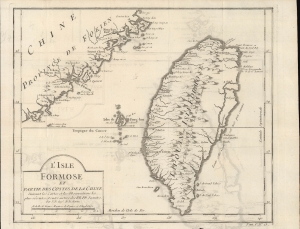
L'Isle Formose et Partie des Costes de la Chine.
$500.00
Acquire
- Digital Map Information
- Suitable for large format printing
- DPI: 600
- File Size: 13.93 MB
- File Type: ZIP / TIFF
- ICC color profile embedded
- Delivered instantly via download link
An important early (c. 1756) European map of Taiwan by Jacques-Nicolas Bellin, which appeared in l'Abbé Prévost's Histoire générale des voyages. Drawing on information from Jesuit missionaries, Bellin's map was among the earliest European maps to focus on the island and the first to employ its contemporary official Chinese name (Taiwan, here as 'Taiouan or Taivan'). (more details)
One of the Earliest Obtainable Maps of Taiwan.
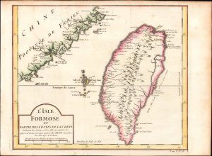
L'Isle Formose et Partie des Costes de la Chine.
$1,200.00
Acquire
- Digital Map Information
- Suitable for large format printing
- File Size: 5.22 MB
- File Type: ZIP / TIFF
- ICC color profile embedded
- Delivered instantly via download link
This is Jacques-Nicolas Bellin's important c. 1756 map of Taiwan, which appeared in l'Abbé Prévost's Histoire Générale des Voyages, here with hand-coloring. Drawing on information from Jesuit missionaries, Bellin's map was among the earliest European maps to focus on the island and the first to employ its contemporary official Chinese name (Taiwan, here as 'Taiouan or Taivan'). (more details)
Barbados at the height of the plantation economy.
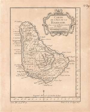
Carte de l'isle de la Barbade pour servir à l'Histoire Générale des Voyages.
$400.00
Acquire
- Digital Map Information
- Suitable for large format printing
- DPI: 600
- File Size: 3.09 MB
- File Type: ZIP / TIFF
- ICC color profile embedded
- Delivered instantly via download link
This is a rare c. 1758 map of Barbados by the French cartographer and hydrographer Jacques-Nicolas Bellin. It was prepared for the Abbé Antoine François Prévost's Histoire générale des voyages. The map shows the island in the heyday of English colonialism, when it was one of the main sources of sugar, produced through a system of brutal plantation slavery. (more details)
A time of increasing tensions between expansionist Russia and Qing China.
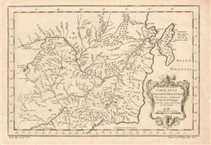
Carte de la Tartarie Orientale Pour Servir a l'Histoire Générale des Voyages Tirée des Cartes Levees par les P.P. Jesuites.
$225.00
Acquire
- Digital Map Information
- Suitable for large format printing
- Full resolution TIFF file
- ICC color profile embedded
- Delivered instantly via download link
This is a 1749 Bellin map of the frontier between Russia and China, during a period of increasing pressure between the expanding Russian Empire and the Qing dynasty. The map covers the Chinese provinces of Jilin and Heilongjiang, and the Russian Amur Oblast, Khabarovsk Krai, Primorsky Krai and Sakhalin Island. (more details)