
Ravell, Anthony (sold)

Anthony Ravell (1675 - July 3, 1727) was a British surveyor. He was born in Leicestershire; nothing is known of his education or upbringing. By 1699 he admitted as a surveyor by the Council of Monserrat; he achieved the title 'Surveyor General of the Leeward Islands' with St. Christopher (Saint Kitts), Nevis and Monserrat falling under his purview. He produced a superb map of St. Christopher, which was published by Sayer in 1770, Jefferys in 1775, and thereafter by both Laurie and Whittle and Le Rouge. There is shockingly little information available about this man - He was listed among the subscribers for Pemberton's 1728 A View of Isaac Newton's Philosophy. He died on July 3, 1727 in Saint Kitts.
Best 18th century chart of St. Kitts and Nevis.
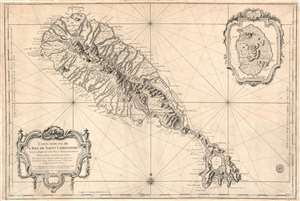
Carte Réduite de L'Isle de Saint Christophe Dressée au Depost des Cartes Plans et Journaux de la Marine, Pour le Service des Vaisseaux du Roy, Par ordre de M. le Marquis de Massiac, Lieutenant General des Armées Navales, Secretaire d'etat aiant le Départment de la Marine, Par le S. Bellin, Ingenieur de la Marine et du Depost des Plans, Censeur Royal de Academe de Marine et de la Societe de Londres. M.DCC.LVIII.
sold
- Digital Map Information
- Suitable for large format printing
- Full resolution TIFF file
- ICC color profile embedded
- Delivered instantly via download link
This is a large, scarce, 1758 Bellin map of the Caribbean islands of St. Christopher / St. Kitts and Nevis. The map is superbly engraved, with dramatic pictorial mountains, finely rendered forests, and two elegantly rendered cartouche frames. The grand scale of the map allows richer detail than any map of these islands we have seen until the Jefferys map based on Anthony Ravell's (1675 - July 3, 1727) c. 1717 survey. Although Ravell's work predates this map, Bellin would not have had access to it, and placenames and navigational details diverge sharply. Like most maps of these islands, including Bellin's own smaller-format map, this was based largely on the surveys of Andrew Norwood (16?? - 1685). The maps of Moll, Bowen, and Mount and Page all relied on Norwood's survey for source material. But this map shows more concrete, contemporaneous data than the Norwood, including individual structures in many cases. Since this was intended for use by the French Navy, it is very likely that more recent intelligence was consulted, none of which has otherwise survived. (more details)
Richly-detailed Surveys of St. Kitts and Nevis.
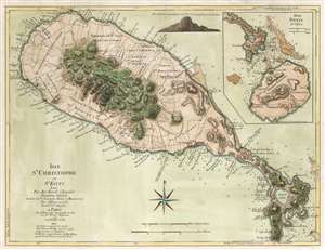
Isle St. Christophe ou St. Kitts Leve Par Ant: Ravell Chevalier Arpenteur Général des Isles de St. Christophe, Nevis et Montserrat. Par Jefferys en 1775. Traduit de l'Anglais A Paris par le Rouge Ingr. Geographe du Roi rue des Grands Augustus 1779 avec Privilege du Roi.
sold
- Digital Map Information
- Suitable for large format printing
- DPI: 600
- File Size: 22.65 MB
- File Type: ZIP / TIFF
- ICC color profile embedded
- Delivered instantly via download link
This Anthony Ravell’s survey map of the islands of St. Christopher and Nevis, in its 1779 French translation published by George-Louis Le Rouge. The map is based on the best 18th century survey of the islands, executed by Anthony Ravell, probably in 1717. Ravell's survey of St. Kitts was not committed to print until Jefferys engraved it for Robert Sayer in 1768; Jefferys would produce a further map of the island (combined with an inset map of Nevis) for his 1775 The West-India Atlas. It is this 1775 Jefferys map that Le Rouge copied to produce the present work. While the gap between 1717 and 1779 seems vast to our sensibility, at the time Ravell's survey remained the most current available: consider that the Mount and Page map of St. Christopher, published as late as 1783, was based on the surveys of Andrew Norwood, who died nearly a century prior in 1685. Norwood's survey also provided the source material for maps by Moll, Bowen, and Bellin. (more details)