
Smith, John (sold)
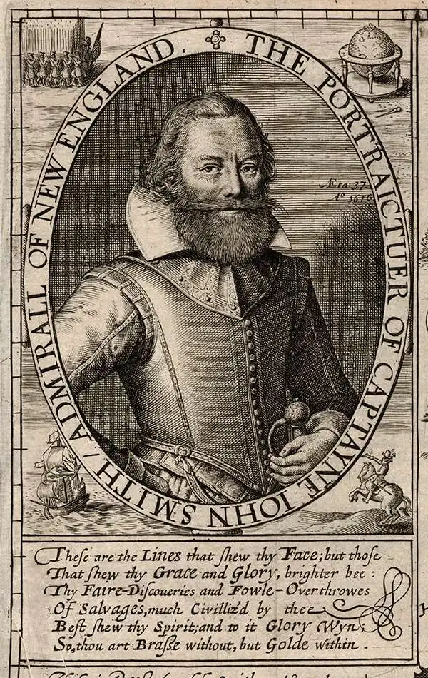
Captain John Smith (1580 - 1631) was an English soldier, explorer, colonial governor, Admiral of New England, author, and self-promoter. He was pivotal in the establishment of the first permanent English settlement in America (Jamestown, Virginia) and was the first Englishman to map the Chesapeake Bay, and the coast of New England. His maps of these areas, especially his mapping of the Chesapeake, were broadly influential: there are few maps of Virginia that were produced in the 17th century that do not derive from his work. His books describing the Virginia Colony were themselves important in encouraging further settlement.
Smith was born to a farming family in Lincolnshire; after his father's death, he began his military career as a mercenary, fighting with the French at war with Spain. He was intermittently a merchant and a pirate in the Mediterranean, where his travels brought him into the fight against the Ottoman Turks. He fought for the Austrian Habsburgs in Hungary, and fought for Radu Șerban in Wallachia against Ottoman vassal Ieremia Movilă. His coat of arms - featuring three Turkish heads - was itself a gruesome memento of Smith's reputedly killing and beheading of three Ottoman challengers in single-combat duels. His fortunes turned in 1602, which saw him captured and enslaved by the Crimean Tatars, captured, and sold as a slave - a condition which apparently lasted only long enough for him to escape to Muscovy, thence to take the scenic route back to England in 1604.
In 1606, Smith was sent as one of the leaders of London's Virginia Company's effort to colonize Virginia. Over the course of the next year, as some sixty percent of the settlers died of starvation and disease, Smith explored Chesapeake Bay and its vicinity, producing his seminal, wildly influential map which would be eagerly copied by mapmakers throughout the next century. Preserved on this map was also a body of water, reported to Smith by Native Americans, which he believed to be either a massive lake, or the Sea of Verrazano - in short, the Pacific. He was forced to return to England in 1609 following his injury in a gunpowder explosion in his canoe. While in England, Smith passed on a tip on this possible Pacific passage to Henry Hudson, who would gain no joy of it.
Smith did not return to Virginia. He did, however, return to America, exploring the coast of New England in 1614. (This name was his own; Smith's New England would be the first map to employ that appellation.) Smith's 1614 journey was meant to capture whales for their oil, and to find gold or copper mines. Failing these, they found instead fish and furs. It is also very likely that in his exploration of the northeastern coast, Smith was the same Sea of Verrazano that so tantalized Hudson.
A difficulty with Smith's biography is that so much of it relies entirely on his own report: and Smith does not at all appear to have been a modest man.
Smith was born to a farming family in Lincolnshire; after his father's death, he began his military career as a mercenary, fighting with the French at war with Spain. He was intermittently a merchant and a pirate in the Mediterranean, where his travels brought him into the fight against the Ottoman Turks. He fought for the Austrian Habsburgs in Hungary, and fought for Radu Șerban in Wallachia against Ottoman vassal Ieremia Movilă. His coat of arms - featuring three Turkish heads - was itself a gruesome memento of Smith's reputedly killing and beheading of three Ottoman challengers in single-combat duels. His fortunes turned in 1602, which saw him captured and enslaved by the Crimean Tatars, captured, and sold as a slave - a condition which apparently lasted only long enough for him to escape to Muscovy, thence to take the scenic route back to England in 1604.
In 1606, Smith was sent as one of the leaders of London's Virginia Company's effort to colonize Virginia. Over the course of the next year, as some sixty percent of the settlers died of starvation and disease, Smith explored Chesapeake Bay and its vicinity, producing his seminal, wildly influential map which would be eagerly copied by mapmakers throughout the next century. Preserved on this map was also a body of water, reported to Smith by Native Americans, which he believed to be either a massive lake, or the Sea of Verrazano - in short, the Pacific. He was forced to return to England in 1609 following his injury in a gunpowder explosion in his canoe. While in England, Smith passed on a tip on this possible Pacific passage to Henry Hudson, who would gain no joy of it.
Smith did not return to Virginia. He did, however, return to America, exploring the coast of New England in 1614. (This name was his own; Smith's New England would be the first map to employ that appellation.) Smith's 1614 journey was meant to capture whales for their oil, and to find gold or copper mines. Failing these, they found instead fish and furs. It is also very likely that in his exploration of the northeastern coast, Smith was the same Sea of Verrazano that so tantalized Hudson.
A difficulty with Smith's biography is that so much of it relies entirely on his own report: and Smith does not at all appear to have been a modest man.
The Classic Dutch Map of Captain John Smith's Virginia.
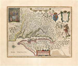
Nova Virginiae Tabula.
sold
- Digital Map Information
- Suitable for large format printing
- Full resolution TIFF file
- ICC color profile embedded
- Delivered instantly via download link
A beautiful, original-color example of Guillaume Blaeu's 1635 map of the Virginia colony and the Chesapeake Bay. Oriented to the west, this map covers from Cape Henry to the Susquehanna River and inland as far as the Appalachian Mountains. The Chesapeake Bay is shown in full as are many of its river estuaries, although topographically this map places a number of mountain ranges where there are in fact none. Cartographically, this map is based upon John Smith's landmark map of the Virginia colony issued in 1612. Smith's fine survey work, as well as reports from indigenous American Indian tribes, and wishful thinking, combine to make this one of the most interesting maps of America to emerge in the 17th century. Philip D. Burden, the author of The Mapping of America, considers this map, Nova Virginiae Tabula, to be
one of the most important maps of America ever produced and certainly one of the greatest influence.(more details)
Captain John Smith's name, applied to contemporary Dutch cartography.
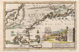
Nieuw Engeland in Twee Scheeptogten door Kapitein Johan Smith inde Iaren 1614 en 1615 Bestevend.
sold
- Digital Map Information
- Suitable for large format printing
- Full resolution TIFF file
- ICC color profile embedded
- Delivered instantly via download link
This is an attractive example of Pieter Van der Aa's 1707 map of New England, issued to illustrate the discoveries Captain John Smith in his 1614 and 1615 voyages. The map covers from the coast of Rhode Island to Penobscot Bay in Maine, showing Cape Cod, Elizabeth Island, and Nantucket. (more details)