
Tiebout, Cornelius (sold)

Cornelius Tiebout (c. 1760 - February 1832) was an American engraver of portraits and maps, possibly the first American-born engraver. He is credited with engraving most of the maps for Christopher Colles' 1789-1790 A Survey of the Roads of the United States of America and for introducing English stippled portraiture to America. Tiebout was born to Tunis Tiebout and Elizbeth Lamb in New York City. They were an hold Huguenot family with lands on the Delaware River as early as 1656. He was initially apprenticed as a silversmith under John Burger (1747 - 1828), but began engraving on copper to make extra money. His imprint appears alongside that of Burger on a collection of psalm tunes from about 1780-1785 - suggesting this is apprentice work. Apprenticeships ran from about 14 - 21, and his master adding his name to the imprint suggesting a late apprenticeship stage, meaning he was likely born about 1766 - 1765. Most references regarding his birth place it around 1773 - 1777, but this latter range seems a stretch. As early as 1789 he was working with Christopher Colles on various projects including A Survey of the Roads of the United States of America. In 1790, Tiebout had a falling out with Colles, abandoned the incomplete road book project, and took work engraving for New York Magazine and Brown' Family Bible. Early in 1793, Tiebout traveled to London where he studied English stipple engraving under James Heath. Returning to New York in 1796, he completed a stipple engraving of John Jay, the first strong example of that style by an American, establishing his reputation as a portraitist. Tiebout remained as an engraver in New York until 1799, after which he relocated to Philadelphia where he achieved some success selling portrait prints, becoming in the process wealthy. In a turn-around, in 1825 most of his riches were lost in a failed business venture of uncertain aspect. Shortly after his financial collapse, Tiebout relocated to New Harmony, Indiana, where he founded a free school of printing and engraving with industrialist William Maclure. He died in February of 1832. Tiebout maintained offices in New York at 24 Golden Hill and 273 Pearl Street.
Exceptional complete example of the First American Road Atlas!
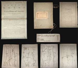
A superb example, entirely complete, of Christopher Colles' 1789 - 1790 A Survey of the Roads of the United States of America. This is the First American Road atlas, wherein at least some of the plates represent the first American maps engraved by a female - Colles' 13-year-old daughter Eliza. Covering depictions from Albany, New York to Williamsburg, Virginia, Colles' atlas consists of a prospectus, a title page, and 83 separate strip maps, each covering some 12 miles of roads and offering invaluable detail about the natural and human landscape of late 18th-century America, and was published in commemoration of the founding of the new republic in 1789. (more details)
Early American map imprint.
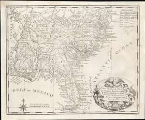
New Map of the States of Georgia South and North Carolina Virginia and Maryland Including the Spanish Provinces of West and East Florida from the latest Surveys.
sold
- Digital Map Information
- Suitable for large format printing
- Full resolution TIFF file
- ICC color profile embedded
- Delivered instantly via download link
An intriguing and extremely scarce 1793 map of the southeastern portions of the United States, including Florida, by Cornelius Tiebout. Predating the Louisiana Purchase, the map covers the full United States as it then existed, as well as Spanish Florida. Coverage extends from the Chesapeake Bay to the Florida Keys and from the Mississippi River to the Atlantic seaboard. An arresting title cartouche in the lower right features an American Flag and is surmounted by a bald eagle. (more details)
One of the earliest American issued maps of the Southeastern States.
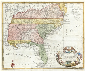
New Map of the States of Georgia South ad North Carolina Virginia and Maryland Including the Spanish Provinces of West and East Florida from the latest Surveys.
sold
- Digital Map Information
- Suitable for large format printing
- Full resolution TIFF file
- ICC color profile embedded
- Delivered instantly via download link
An intriguing and extremely scarce 1793 map of the southeastern portions of the United States, including Florida, by Cornelius Tiebout. The map covers from the Chesapeake Bay to the Florida Keys ad from the Mississippi River to the Atlantic seaboard. For an ... (more details)