
Woodford, Edgar Maurice (sold)

Edgar Maurice Woodford (April 15, 1824 – October 1, 1862) was a mid-19th century American abolitionist, civil engineer, surveyor, and map publisher active in New England. Woodford was born on his family farm in Avon, Connecticut. Although self-taught as a surveyor, he rose to become the official Hartford County surveyor. He was described by a nephew as 'a great strapping man,' who would come 'over the hills with his [surveying] instruments over his shoulder, crying for fear his work would not come out right.' Woodford produced numerous county surveys in Connecticut, Maine, and Massachusetts. Typically Woodford worked with other cartographers, but from time to time, he published independently, including his maps of Belfast and Frankfort, Maine, as well as Belknap, New Hampshire. As an abolitionist Woodford was part of the 1856 'Connecticut Colony in Kansas,' an attempt to colonize Kansas with enough abolitionist New Englanders to sway the vote and force Kansas to enter the Union as a Free State. When the Civil War broke out he enlisted in the Seventh Connecticut Volunteer Infantry, where he was assigned the rank of Quartermaster. It was during the war when he passed away in Hilton Head Island, South Carolina, of 'congestive fever,' an archaic term for malaria. He is interred in the soldiers cemetery at Hilton Head.
Home to two of seven recorded millionaires in the U.S. - both sea captains.
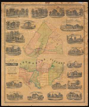
Map of the Town of Thomaston Lincoln Co. Maine.
sold
- Digital Map Information
- Suitable for large format printing
- File Size: 134.9 MB
- File Type: ZIP / TIFF
- ICC color profile embedded
- Delivered instantly via download link
A charming and rare 1855 map of Thomaston, a town in the Penobscot Bay region of mid-coast Maine. The map is divided into two sections. The upper map details greater Thomaston area. The lower map is a detail of Thomaston Village. Exceptional detail offering interesting insights throughout. When this map was issued, Thomaston was a prosperous port and ship building center. Pay particular attention to the kilns, shipyards and wharves shown along the Mill River and at the head of the bay. In 1840, not long before this map was issued, two of seven recorded millionaires in the United States were Thomaston sea captains - a fact that illustrates Thomaston's historical wealth. Both maps are surrounded by vignette images of important residences, many of which still stand. The Knox Mansion, appearing in the upper left, was at the time the grandest home in Maine and is today a museum. (more details)
The best early wall map of Hartford County, Connecticut.
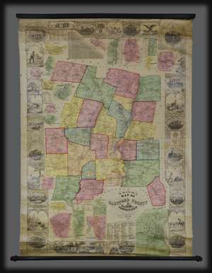
This is a rare and spectacular 1855 wall map of Hartford County, Connecticut by Edgar M. Woodford. Centered on the city of Hartford and the Connecticut River, this map covers the entire county and is color coded by township. Countless individual property holders and homes are identified throughout. The map features a wide decorative border with images of the State House in Hartford, State Normal School in New Britain, Connecticut Literary Institution in Suffield, the home of Col. A. G. Hazard in Enfield, the elegant Residence of Wm. H. Jones with View of Silk Factory, the Charter Oak, wildlife, and an Indian Warrior. Twenty insets surrounding the map are large and detailed town plans of Hartford, Farmington, Rockyhill, New Britain, Wethersfield, Glastonbury (Glastenbury), South Glastonbury (Glastenbury), Windsor Locks, Thompsonville, Broad Brook, Warehouse Point, Plainville, Cheneyville, Southington, Unionville, Collinsville, Hazardville, Plantsville, and Berlin. (more details)
Largest 19th century map of Lake Winnipesaukee.
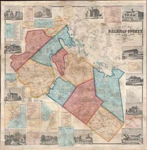
Map of Belknap County New Hampshire.
sold
- Digital Map Information
- Suitable for large format printing
- File Size: 157.63 MB
- File Type: ZIP / TIFF
- ICC color profile embedded
- Delivered instantly via download link
A striking 1859 E. M. Woodford wall map of Belknap County, New Hampshire, embracing Lake Winnipesaukee and the southern tier of the White Mountains - for a generation the largest and most detailed map of this region. Coverage includes all of Lake Winnipesaukee and Belknap County to the southwest. Shading divides the county into constituent townships, with roads, placenames, and topography rendered in hachure. There are 16 inset detail maps, focusing on important communities, and 13 vignette views of prominent homesteads and businesses. In addition to its size and detail, this is most significant for naming thousands of landowners and residents, as well as important businesses, thus offering a unique record of Belknap in the mid-19th century. (more details)