

Hindostan or British India.
sold
- Digital Map Information
- Suitable for large format printing
- File Size: 7.99 MB
- File Type: ZIP / TIFF
- ICC color profile embedded
- Delivered instantly via download link
A beautiful 1855 first edition example of Colton's map of India. Covers the subcontinent from Tibet to Ceylon (Sri Lanka). Color coded according to region and divided into Bombay, Scinde, Punjab, Nepal, Bhutan, the Bengal Presidency, Madras and Ceylon. An inset ... (more details)

Japan, Nippon, Kiusiu, Sikok, Yesso and the Japanese Kuriles.
sold
- Digital Map Information
- Suitable for large format printing
- File Size: 8.36 MB
- File Type: ZIP / TIFF
- ICC color profile embedded
- Delivered instantly via download link
A beautiful 1855 first edition example of Colton's map of Japan. Compiled from the maps of Siebold and from the 1850 U.S. Japan Expedition (Perry). Covers the Japanese Islands from Kiusiu north to Yesso (Hokkaido). Offers considerable detail with color cording ... (more details)

Sweden and Norway.
sold
- Digital Map Information
- Suitable for large format printing
- File Size: 7.79 MB
- File Type: ZIP / TIFF
- ICC color profile embedded
- Delivered instantly via download link
A beautiful 1855 first edition example of Colton's map of Norway and Sweden. Covers from the Arctic Sea south to Denmark and east as far as the Gulf of Finland. Includes the modern day nations of Sweden and Norway, with part of adjacent Denmark and Finland. ... (more details)

Africa North Eastern Sheet.
sold
- Digital Map Information
- Suitable for large format printing
- File Size: 8.66 MB
- File Type: ZIP / TIFF
- ICC color profile embedded
- Delivered instantly via download link
A beautiful 1855 first edition example of Colton's map of north eastern Africa. Covers from the Mediterranean south as far as Mount Kenya, west as far as Tripoli, and east to include most of Arabia. This is one of the first American map to depict Mount ... (more details)
Important early map of the Great Lakes and upper Mississippi Valley.
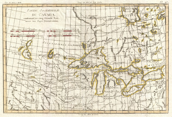
Partie Occidentale du Canada, contenant les cinq Grands Lac, avec les Pays Circonviosins.
sold
- Digital Map Information
- Suitable for large format printing
- DPI: 300
- File Size: 4.01 MB
- File Type: ZIP / TIFF
- ICC color profile embedded
- Delivered instantly via download link
An extremely attractive example of Rigobert Bonne's c. 1775 map of the Great Lakes and upper Mississippi Valley. A map of considerable importance, this map was constructed during a period of aggressive exploration into this region. The French and ... (more details)

Carte des Gouvernements de Flandre Francoise, d'Artois, de Picardie et du Boulenois.
sold
- Digital Map Information
- Suitable for large format printing
- DPI: 300
- File Size: 7.43 MB
- File Type: ZIP / TIFF
- ICC color profile embedded
- Delivered instantly via download link
A beautiful example of Rigobert Bonne's decorative map of the French regions of Picardy, Artois, and French Flanders. Covers the region in full from the English Chanel to Normandy. large decorative title cartouche appears in the upper right ... (more details)
18th century map of the Languedoc wine region!

Carte des Gouvernements de Languedoc, de Foix et de Roussillon avec la Partie Oriental du Gouvernement de Guinne.
sold
- Digital Map Information
- Suitable for large format printing
- DPI: 300
- File Size: 9.11 MB
- File Type: ZIP / TIFF
- ICC color profile embedded
- Delivered instantly via download link
A beautiful example of Rigobert Bonne's decorative map of the French winemaking regions of Languedoc, de Foix and Roussillon. Covers the region in full from Auvergne to the Spain adn the Mediterranean. This region is the largest producer ... (more details)
18th century map of the Anjou (Loire) wine region!
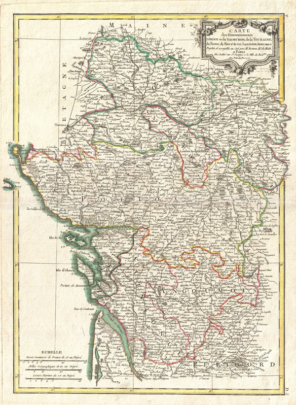
Carte des Gouvernements D'Anjou et du Saumurois, de la Touraine,du Poitou, du Pays d'aunis, Saintonge-Angoumois.
sold
- Digital Map Information
- Suitable for large format printing
- DPI: 300
- File Size: 8.16 MB
- File Type: ZIP / TIFF
- ICC color profile embedded
- Delivered instantly via download link
A beautiful example of Rigobert Bonne's decorative map of the French winemaking regions of Poitou, Touraine, Anjou, and Saumur. Covers the region in full from Maine to Perigord and from the Atlantic to Isle de France. This region, which ... (more details)
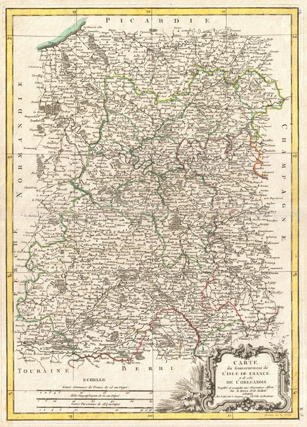
Carte du Gouvernement de L'Isle de France et de celui de L'Orleanios.
sold
- Digital Map Information
- Suitable for large format printing
- DPI: 300
- File Size: 8.58 MB
- File Type: ZIP / TIFF
- ICC color profile embedded
- Delivered instantly via download link
A beautiful example of Rigobert Bonne's decorative map of the French regions of Isle de France and Orleans. Covers the region in full from Picardie to Berriand from Normandy to Champagne. This region, centered around Paris, is France's ... (more details)

Carte des Gouvernements de Dauphine et de Provence avec le Comtat Venaissin et la Princte. D'Orange.
sold
- Digital Map Information
- Suitable for large format printing
- DPI: 300
- File Size: 8.1 MB
- File Type: ZIP / TIFF
- ICC color profile embedded
- Delivered instantly via download link
A beautiful example of Rigobert Bonne's decorative map of the French regions of Provence and Dauphine. Covers the region in full from Savoy to the Mediterranean and from Languedoc to Nice. This region, known as the playground of ... (more details)
18th century map of the Burgundy wine region!

Carte des Gouvernements de Bourgogne, de Franche Comte et de Lyonnois.
sold
- Digital Map Information
- Suitable for large format printing
- DPI: 300
- File Size: 8.67 MB
- File Type: ZIP / TIFF
- ICC color profile embedded
- Delivered instantly via download link
A beautiful example of Rigobert Bonne's decorative map of the French winemaking region of Burgundy, and the adjacent regions of Franche-Comte and Lyonnais. Covers the region in full from Champagne to Dauphine and from Auvergne ... (more details)
18th century map of the Champagne wine region!

Carte du Gouvernement de Champagne et Brie.
sold
- Digital Map Information
- Suitable for large format printing
- DPI: 300
- File Size: 8.58 MB
- File Type: ZIP / TIFF
- ICC color profile embedded
- Delivered instantly via download link
A beautiful example of Rigobert Bonne's decorative map of the French winemaking region of Champagne and the cheese making region of Brie. Covers the departments of Champagne and Brie from Picardie to Franche and from Isle de ... (more details)

L'Europe divisee en ses Principaux Etats.
sold
- Digital Map Information
- Suitable for large format printing
- DPI: 300
- File Size: 9.33 MB
- File Type: ZIP / TIFF
- ICC color profile embedded
- Delivered instantly via download link
A beautiful first edition example of Jean Janvier's decorative map of the Europe. Janvier's map covers from Iceland to the Caspian Sea and from North Africa to the Arctic. The map is divided into countries and kingdoms with ... (more details)

Carte de L'Empire D'Alemagne avec les Etats de Boheme.
sold
- Digital Map Information
- Suitable for large format printing
- DPI: 300
- File Size: 35.72 MB
- File Type: ZIP / TIFF
- ICC color profile embedded
- Delivered instantly via download link
A rare compete example of Rizzi-Zannoni's decorative four panel map of the German Empire and Poland. Covers from Jutland to the Gulf of Venice and from England to Poland. Offers excellent detail throughout showing ... (more details)
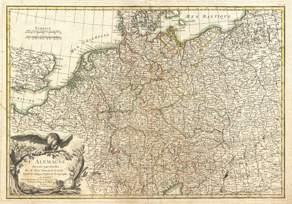
L'Alemagne Divisee par Cercles.
sold
- Digital Map Information
- Suitable for large format printing
- DPI: 300
- File Size: 10.54 MB
- File Type: ZIP / TIFF
- ICC color profile embedded
- Delivered instantly via download link
A beautiful example of Rizzi-Zannoni's decorative map of Germany. Covers from Jutland to the Gulf of Venice and from England to Poland.. Offers excellent detail throughout showing mountains, rivers, forests, ... (more details)

La Suisse divisee en ses Treize Cantons et ses Allies.
sold
- Digital Map Information
- Suitable for large format printing
- DPI: 300
- File Size: 8.59 MB
- File Type: ZIP / TIFF
- ICC color profile embedded
- Delivered instantly via download link
A beautiful example of Rigobert Bonne's decorative map of Switzerland. Covers the entirety of Switzerland divided into Cantons. Offers excellent detail throughout showing mountains, rivers, forests, national ... (more details)
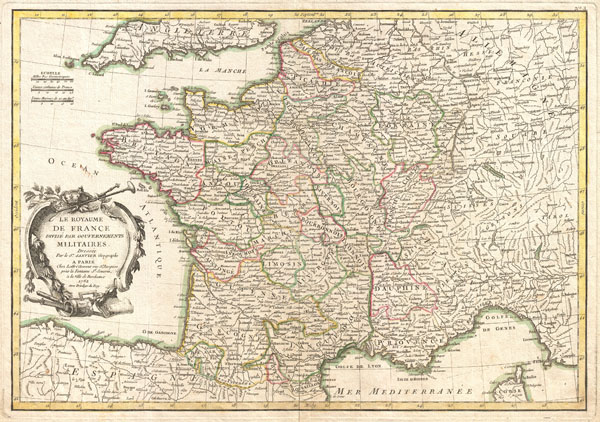
La Royaume de France Divise Par Gouvernements Militaires.
sold
- Digital Map Information
- Suitable for large format printing
- Full resolution TIFF file
- ICC color profile embedded
- Delivered instantly via download link
A beautiful example of Jean Janvier's decorative map of France. Covers the entirety of France from England to Corsica and from Germany to Spain. Divided into military departments with color coding according ... (more details)

Carte Generale de France divisee par Gouvernements.
sold
- Digital Map Information
- Suitable for large format printing
- Full resolution TIFF file
- ICC color profile embedded
- Delivered instantly via download link
A beautiful example of Rigobert Bonne's decorative map of France. Covers the entirety of France from Spain to Germany and from the British Channel to the Mediterranean. Divided into provinces with color ... (more details)

Sphere de Ptolomee.
sold
- Digital Map Information
- Suitable for large format printing
- DPI: 300
- File Size: 6.59 MB
- File Type: ZIP / TIFF
- ICC color profile embedded
- Delivered instantly via download link
A beautiful example of Rigobert Bonne's curious decorative chart of the Spheres. Features five different spheres used in mapmaking and calculating map projections. From top left, Sphere de Ptolomee, ... (more details)

Russie D'Europe avec la partie la plus peuplee de celle D'Asie.
sold
- Digital Map Information
- Suitable for large format printing
- DPI: 300
- File Size: 8.38 MB
- File Type: ZIP / TIFF
- ICC color profile embedded
- Delivered instantly via download link
A beautiful example of Jan Janvier's curious decorative map of Western Russia. Covers from Poland and the Baltic Sea eastward as far as Ilimskoy, Siberia, extends south to the Black Sea and north as ... (more details)