
Printed for the members of the Seventh Armored Division in Germany before their departure for the United States.

The Box Score.
sold
- Digital Map Information
- Suitable for large format printing
- Full resolution TIFF file
- ICC color profile embedded
- Delivered instantly via download link
This is a 1945 Lerman World War II pictorial route map of the 7th Armored Division in Europe. Illustrations, information, and geography combine to create a stunning visual summary of the 7th Armored's march across the continent. (more details)
Only known example of Dobson's survey of Riverdale and Pullman, Chicago.

Map of Riverdale and Surroundings, Cook County, Ills.
sold
- Digital Map Information
- Suitable for large format printing
- File Size: 14.28 MB
- File Type: ZIP / TIFF
- ICC color profile embedded
- Delivered instantly via download link
An exceptionally rare 1874 survey map of Riverdale, Illinois, a suburb of Chicago bordering the Calumet. The survey centers on a bend in the Little Calumet River just east of the modern day limits of Riverdale, including the lavish Wildwood estate of the ... (more details)
A map of San Diego on the brink of World War II.
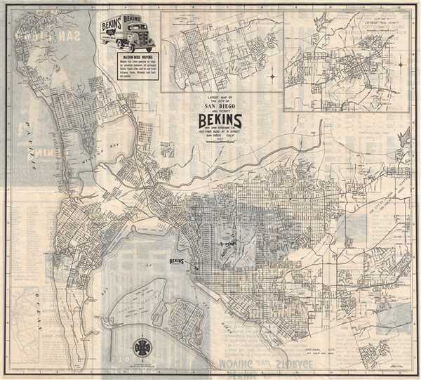
Latest Map of the City of San Diego and Vicinity.
sold
- Digital Map Information
- Suitable for large format printing
- File Size: 10.28 MB
- File Type: ZIP / TIFF
- ICC color profile embedded
- Delivered instantly via download link
This is a 1940 Bekins Van and Storage Company city map or plan of San Diego, California. The map depicts the city of San Diego from the Pacific Ocean to La Mesa and Paradise Hills and from La Jolla Bay to Coronado and National City. Highly detailed, ... (more details)
Eye-catching infographic map illustrating American foreign investment in the Interwar Years.

American Foreign Investments.
sold
- Digital Map Information
- Suitable for large format printing
- File Size: 7.27 MB
- File Type: ZIP / TIFF
- ICC color profile embedded
- Delivered instantly via download link
This is a c. 1923 Fortune Magazine and Jenter Exhibits infographic map of American foreign investments. The map depicts several different regions of the world, including Asia from Russia and Japan to Australia and from Thailand and Indonesia to New ... (more details)
Visually striking Italian map of Italy.
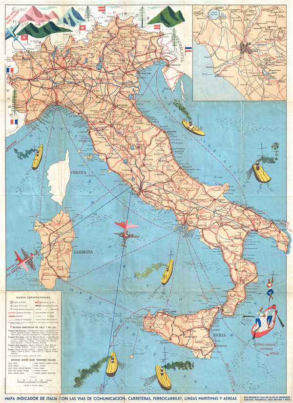
Mapa Indicador de Italia con las Vias de Comunicacion: Carreteras, Ferroarriles, Lineas Maritimas y Aereas.
sold
- Digital Map Information
- Suitable for large format printing
- File Size: 13.75 MB
- File Type: ZIP / TIFF
- ICC color profile embedded
- Delivered instantly via download link
This is a c. 1957 Stab. L. Salomone map of Italy. The map depicts Italy from France, Switzerland, and Austria to Sicily and the Mediterranean Sea and from Corsica and Sardinia to the Adriatic Sea and Yugoslavia. The Italian road and rail network ... (more details)
Attractive large format map of Brooklyn, New York. Includes the outer parts of Brooklyn that were incorporated into the borough after the turn of the century.
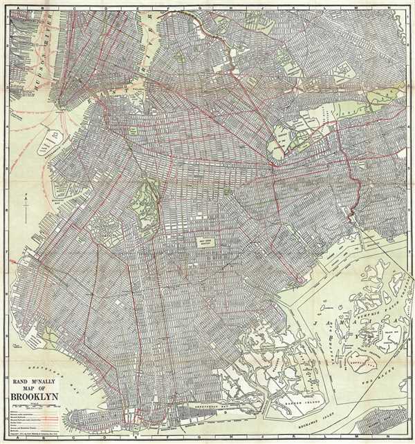
Rand McNally Map of Brooklyn.
sold
- Digital Map Information
- Suitable for large format printing
- File Size: 31.85 MB
- File Type: ZIP / TIFF
- ICC color profile embedded
- Delivered instantly via download link
This impressive map is a large format edition of Rand McNally's 1917 map of Brooklyn, New York. Unlike most earlier maps of Brooklyn, this map covers Brooklyn much as it appears today, extending from New York Harbor to Woodhaven (Queens) and ... (more details)
The IRT, BMT, and Independent lines were still divided!

New York City Transit System.
sold
- Digital Map Information
- Suitable for large format printing
- File Size: 3.84 MB
- File Type: ZIP / TIFF
- ICC color profile embedded
- Delivered instantly via download link
This is a c. 1940 George J. Nostrand map of the New York City Transit System. The map depicts Manhattan, Brooklyn, the Bronx, and Queens and part of Staten Island. Lines of the Interborough Rapid Transit Company (IRT), the Brooklyn-Manhattan ... (more details)
Attractive and entertaining game board promoting an adventure radio serial.

Jack Armstrong's Chart Game: Adventures with the Dragon Talisman
sold
- Digital Map Information
- Suitable for large format printing
- File Size: 13.04 MB
- File Type: ZIP / TIFF
- ICC color profile embedded
- Delivered instantly via download link
This is a 1936 Hal G. Arbo fantasy map of Jack Armstrong's adventures through Asia. The map depicts Asia from India to Japan and the Philippines and from the Mongolia and the Gobi Desert to Sri Lanka, Singapore, and Indonesia (Borneo and ... (more details)
Includes intriguing overprinting labeling Oklahoma railroads across the state.
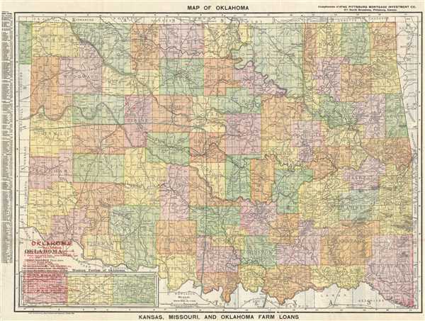
Map of Oklahoma.
sold
- Digital Map Information
- Suitable for large format printing
- File Size: 20.23 MB
- File Type: ZIP / TIFF
- ICC color profile embedded
- Delivered instantly via download link
This is a 1909 Rand McNally railroad map of Oklahoma. The map depicts the state of Oklahoma from New Mexico and Texas to Arkansas and Missouri and from Kansas to Texas with the majority of the panhandle depicted in an inset map at the ... (more details)
Proof state of J. W. Hill's spectacular view of Boston Harbor.
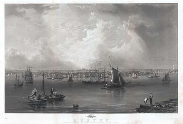
Boston.
sold
- Digital Map Information
- Suitable for large format printing
- File Size: 61.78 MB
- File Type: ZIP / TIFF
- ICC color profile embedded
- Delivered instantly via download link
This is an early proof state of an 1857 view of Boston Harbor by John William Hill. The view exhibits a sweeping majesty, is finely engraved, and impressively proportioned, and as such is one of the finest mid-19th century ... (more details)
Built to commemorate the American victory at the Battle of Bennington during the American Revolutionary War.

Bennington Battle Monument.
sold
- Digital Map Information
- Suitable for large format printing
- File Size: 5.89 MB
- File Type: ZIP / TIFF
- ICC color profile embedded
- Delivered instantly via download link
This is an 1891 Wells and Coverly view of the Bennington Battle Monument in Bennington, Vermont, a monument built to commemorate the Battle of Bennington during the American Revolutionary War. The view depicts all 301 feet ... (more details)
Depicts the course of the Allegheny and Monongahela in detail - labels Morgantown and Pittsburgh!
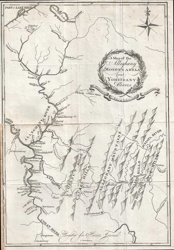
A Map of the Alleghany Monongahela and Yohiogany Rivers.
sold
- Digital Map Information
- Suitable for large format printing
- DPI: 300
- File Size: 2.99 MB
- File Type: ZIP / TIFF
- ICC color profile embedded
- Delivered instantly via download link
This is an extremely scarce 1805 Thaddeus Mason Harris map of his journey through the region surrounding the confluence of the Alleghany and Monongahela Rivers at Pittsburgh (Pittsburg), Pennsylvania. The map depicts the ... (more details)
Land used by Virginia to pay its American Revolutionary War veterans.
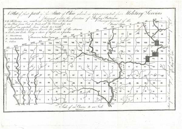
A Plat of theat part of the State of Ohio which is appropriated for Military Services.
sold
- Digital Map Information
- Suitable for large format printing
- DPI: 300
- File Size: 1.48 MB
- File Type: ZIP / TIFF
- ICC color profile embedded
- Delivered instantly via download link
This is an 1805 Rufus Putnam map of the Virginia Military District in present-day Ohio. The map depicts the District from Range I to Range XX and from Township I to Township X within the Plat. Rivers and streams are ... (more details)
Hilarious pictorial map of Yellowstone National Park.

A Hysterical Map of the Yellowstone Park with Apologies to the Park. Smileage Guaranteed.
sold
- Digital Map Information
- Suitable for large format printing
- File Size: 6.57 MB
- File Type: ZIP / TIFF
- ICC color profile embedded
- Delivered instantly via download link
A cheerful 1948 pictorial map of Yellowstone Park, 'hatched and scratched' by the American printer and humorist Jolly Elmer Lindgren. The map depicts the whole of Yellowstone Park with a richly humorous array of ... (more details)
Highly attractive - and humorous! - map of Atlanta, Georgia bordered by columns and peach blossoms.

Atlanta.
sold
- Digital Map Information
- Suitable for large format printing
- File Size: 48.03 MB
- File Type: ZIP / TIFF
- ICC color profile embedded
- Delivered instantly via download link
This is an extremely rare and creative 1972 Trans Continental Cartographers pictorial map of Atlanta. The map depicts the city of Atlanta in a nonconventional manner, creating a map that is meant more for ... (more details)
Incredible view of the Marietta Earthworks - and ancient ceremonial site constructed by the Hopewell Culture.

A bird's eye view of the ancient Works on the Muskingum.
sold
- Digital Map Information
- Suitable for large format printing
- DPI: 300
- File Size: 2.67 MB
- File Type: ZIP / TIFF
- ICC color profile embedded
- Delivered instantly via download link
This is an 1805 Thaddeus Mason Harris view of the 'ancient works' along the Muskingum River in Ohio, known today as the Marietta Earthworks. The view depicts the earthworks in some detail, although all ... (more details)
Charming gameboard of the United States with beautiful vignettes illustrating life in each state!

The United States Air Mail Game.
sold
- Digital Map Information
- Suitable for large format printing
- File Size: 1.89 MB
- File Type: ZIP / TIFF
- ICC color profile embedded
- Delivered instantly via download link
This is a c. 1929 Parker Brothers gameboard map of the United States. The map depicts the continental United States from the Canada (labeled here as the Dominion of Canada) to Mexico and from the ... (more details)
Identifies numerous locations around Manhattan - including Central Park and the Empire State Building!

Supervue of New York City.
sold
- Digital Map Information
- Suitable for large format printing
- Full resolution TIFF file
- ICC color profile embedded
- Delivered instantly via download link
This is a stunning Samuel Freedman 1937 bird's eye view map or view of New York City. The view covers all of Manhattan Island and extends from Liberty Island and the northern end of Governor's ... (more details)
The Yucatan Peninsula is shaded a different color than the rest of Mexico.
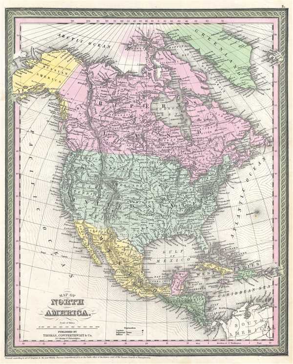
North America.
sold
- Digital Map Information
- Suitable for large format printing
- DPI: 300
- File Size: 7.97 MB
- File Type: ZIP / TIFF
- ICC color profile embedded
- Delivered instantly via download link
This is an 1853 Samuel Augustus Mitchell map of North America. The map depicts from the Arctic Ocean to South America and from the Pacific Ocean to the Atlantic Ocean, Greenland, and the ... (more details)
Battlefield strategy from the Korean War owned by General Barriger with manuscript annotations.

[Barriger Map of Ch'orwon, Korea]
sold
- Digital Map Information
- Suitable for large format printing
- File Size: 12.38 MB
- File Type: ZIP / TIFF
- ICC color profile embedded
- Delivered instantly via download link
This is a c. 1953 U.S. Army field strategy map of Korea formally owned by Major General William Lillard Barriger with fascinating tactical annotations in manuscript. The map depicts the ... (more details)