

United States.
sold
- Digital Map Information
- Suitable for large format printing
- File Size: 9.14 MB
- File Type: ZIP / TIFF
- ICC color profile embedded
- Delivered instantly via download link
An attractive 1891 map of the United States by Rand McNally and Company. It covers the United States in its entirety and includes parts of Canada and Mexico. Major cities, towns, rivers, mountains, railroads and other important topographical features are ... (more details)
Scarce highly detailed English language Japanese map of Tokyo published for travelers to the Tsukiji Foreign Settlement.

New Map of Tokio Divided into Ninth Ri Sections for Measuring Distances.
sold
- Digital Map Information
- Suitable for large format printing
- File Size: 30.49 MB
- File Type: ZIP / TIFF
- ICC color profile embedded
- Delivered instantly via download link
A scarce 1886 Meiji 19 English language map of Tokyo, Japan, issued by M. Nishinomiya and G. Nakamura. Prepared and published for foreign travelers, missionaries, diplomats, and businessmen living in the Tsukiji Foreign Settlement, this remarkable map ... (more details)
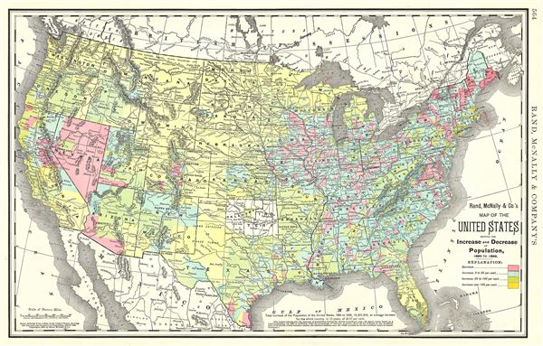
Map of the United States showing the Increase and Decrease of Population, 1880 to 1890.
sold
- Digital Map Information
- Suitable for large format printing
- File Size: 9.3 MB
- File Type: ZIP / TIFF
- ICC color profile embedded
- Delivered instantly via download link
An attractive 1892 Rand McNally and Company map of the United States, showing the increase and decrease of population from 1880 to 1890. Divided by color coding into four degrees ranging from decrease to increase over 100 percent, the map notes an ... (more details)

Map of New York City.
sold
- Digital Map Information
- Suitable for large format printing
- File Size: 19.57 MB
- File Type: ZIP / TIFF
- ICC color profile embedded
- Delivered instantly via download link
An uncommon 1892 Rand McNally and Company map or plan of New York City. It covers all of Manhattan and the Bronx as well as parts of Brooklyn, Queens, New Jersey and Westchester. An inset in the lower right quadrant focuses on the business ... (more details)
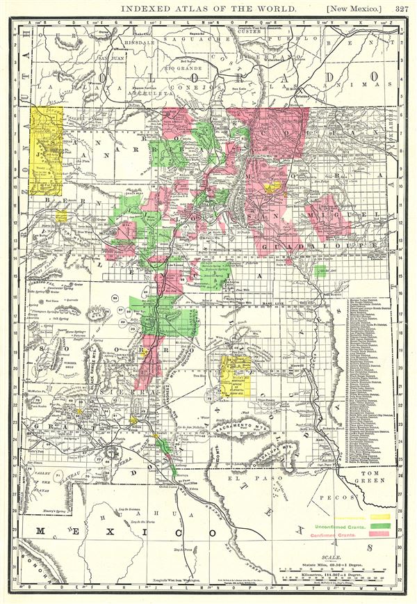
New Mexico.
sold
- Digital Map Information
- Suitable for large format printing
- File Size: 6.98 MB
- File Type: ZIP / TIFF
- ICC color profile embedded
- Delivered instantly via download link
This is a beautiful 1888 Rand McNally and Company map of New Mexico. It covers the state of New Mexico along with parts of neighboring states. This highly detailed map notes several towns, rivers, mountains, railroads, Indian reservations, ... (more details)
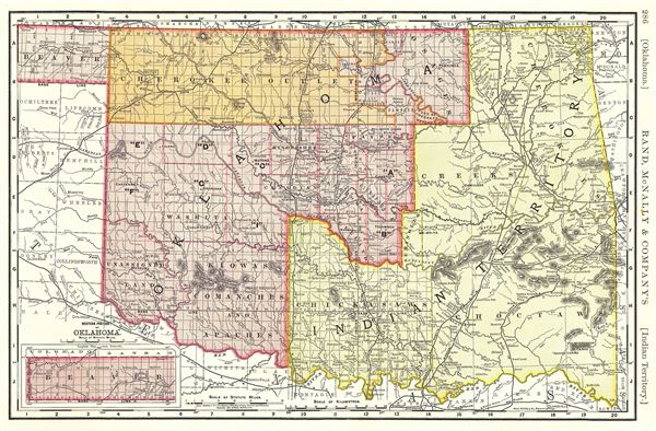
Oklahoma. Indian Territory.
sold
- Digital Map Information
- Suitable for large format printing
- File Size: 8.47 MB
- File Type: ZIP / TIFF
- ICC color profile embedded
- Delivered instantly via download link
A fascinating 1892 Rand McNally and Company map of the Oklahoma and Indian Territories. It covers the Oklahoma Territory and the Indian Territory prior to the before they were admitted as a single state of Oklahoma in 1907. An inset in the ... (more details)

Map of Brooklyn and Vicinity.
sold
- Digital Map Information
- Suitable for large format printing
- File Size: 17.19 MB
- File Type: ZIP / TIFF
- ICC color profile embedded
- Delivered instantly via download link
This is an excellent 1891 Rand McNally and Company map or plan of Brooklyn, New York. It covers Brooklyn from Long Island to Jamaica Bay, including parts of Manhattan, Queens and Jersey City. This extremely detailed map identifies major ... (more details)
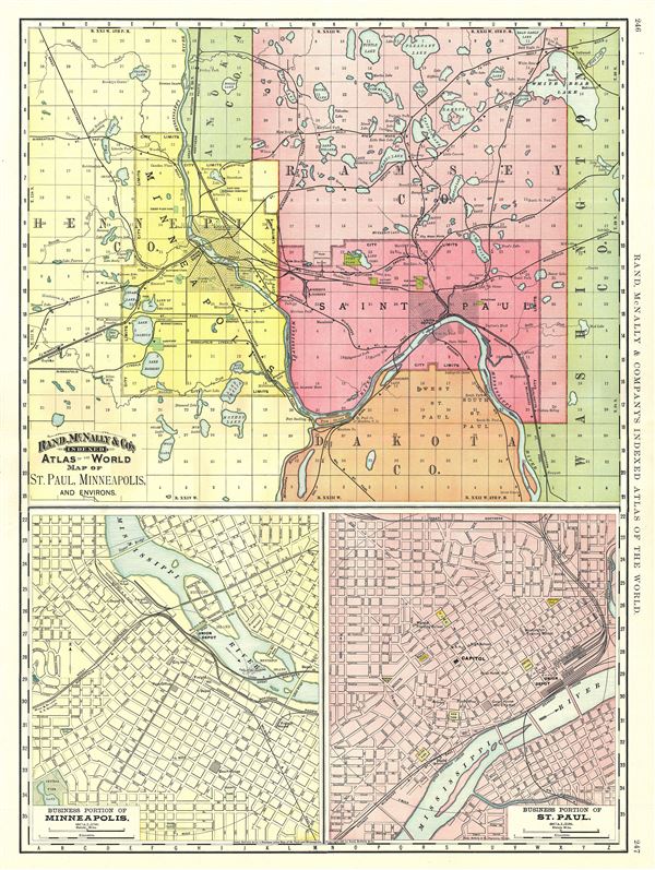
Map of St. Paul, Minneapolis, and Environs.
sold
- Digital Map Information
- Suitable for large format printing
- File Size: 17.99 MB
- File Type: ZIP / TIFF
- ICC color profile embedded
- Delivered instantly via download link
A beautiful 1891 Rand McNally and Company map of St. Paul and Minneapolis, Minnesota. Divided into three parts, the top half of the sheet features a map of St. Paul, Minneapolis and environs. It covers from Hennepin County to Washington ... (more details)
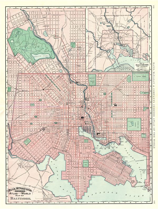
Map of Baltimore.
sold
- Digital Map Information
- Suitable for large format printing
- File Size: 18.5 MB
- File Type: ZIP / TIFF
- ICC color profile embedded
- Delivered instantly via download link
This is an excellent 1891 Rand McNally and Company map or plan of the city of Baltimore, Maryland. It covers the city from Woodberry to the Patapsco River. An inset in the upper right quadrant features a map of Baltimore and environs. ... (more details)
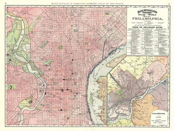
Map of Philadelphia.
sold
- Digital Map Information
- Suitable for large format printing
- File Size: 20.15 MB
- File Type: ZIP / TIFF
- ICC color profile embedded
- Delivered instantly via download link
This is a beautiful 1891 map or plan of the city of Philadelphia, Pennsylvania by Rand McNally and Company. This city plan covers Philadelphia from the Fairmount to Treaty (Petty's) Island. Part of Camden New Jersey is also included. ... (more details)

Map of Toledo.
sold
- Digital Map Information
- Suitable for large format printing
- File Size: 7.89 MB
- File Type: ZIP / TIFF
- ICC color profile embedded
- Delivered instantly via download link
An appealing 1892 map or plan of the city of Toledo by Rand McNally and Company. Centered on the Maumee River, it covers the city of Toledo from Norwood University Place to Duck Creek. Throughout, the map notes individual streets, ... (more details)
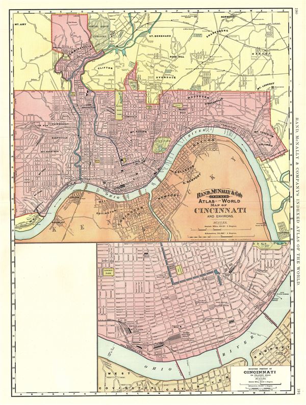
Map of Cincinnati and Environs.
sold
- Digital Map Information
- Suitable for large format printing
- File Size: 17.71 MB
- File Type: ZIP / TIFF
- ICC color profile embedded
- Delivered instantly via download link
A beautiful 1891 Rand McNally and Company map or plan of the city of Cincinnati, Ohio. The map covers the city of Cincinnati from Spring Grove Cemetery south across the Ohio River to Covington in Kentucky. The map is extremely ... (more details)

Map of Milwaukee.
sold
- Digital Map Information
- Suitable for large format printing
- File Size: 9.02 MB
- File Type: ZIP / TIFF
- ICC color profile embedded
- Delivered instantly via download link
A fine 1892 map or plan of the city of Milwaukee, Wisconsin, issued by the Rand McNally and Company. It covers the entire city in great detail from St. John Cemetery to Greenwood Cemetery. It identifies individual streets and ... (more details)

Map of St. Louis.
sold
- Digital Map Information
- Suitable for large format printing
- File Size: 19.51 MB
- File Type: ZIP / TIFF
- ICC color profile embedded
- Delivered instantly via download link
This is an attractive 1891 Rand McNally map or plan of the city of St. Louis, Missouri. It covers the city from the city limits east across the Mississippi River to Horseshoe Lake in Illinois. In addition to all major ... (more details)

Nevada.
sold
- Digital Map Information
- Suitable for large format printing
- File Size: 8.6 MB
- File Type: ZIP / TIFF
- ICC color profile embedded
- Delivered instantly via download link
An attractive 1888 map of Nevada issued by Rand McNally and Company in 1888. The entire state is covered in great detail, noting important towns, cities, rivers, lakes, mountains, and other topographical features. ... (more details)
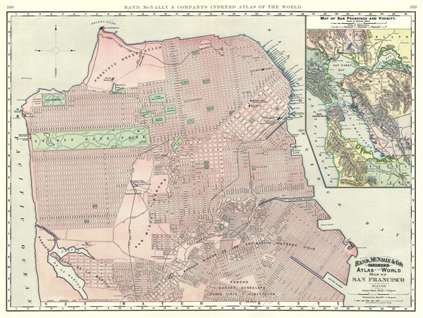
Map of San Francisco.
sold
- Digital Map Information
- Suitable for large format printing
- File Size: 19.73 MB
- File Type: ZIP / TIFF
- ICC color profile embedded
- Delivered instantly via download link
This is a beautiful map of the city of San Francisco, California, issued by Rand McNally and Company in 1891. It covers the entire city from Fort Point and Presidio Park as far south as the Laguna de la Merced. ... (more details)
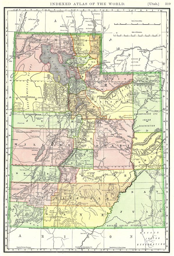
Utah.
sold
- Digital Map Information
- Suitable for large format printing
- File Size: 8.5 MB
- File Type: ZIP / TIFF
- ICC color profile embedded
- Delivered instantly via download link
This is a beautiful 1888 Rand McNally and Company map of Utah. It covers the state noting several towns, cities, rivers, lakes, mountains and a host of other topographical features. The map is color coded ... (more details)
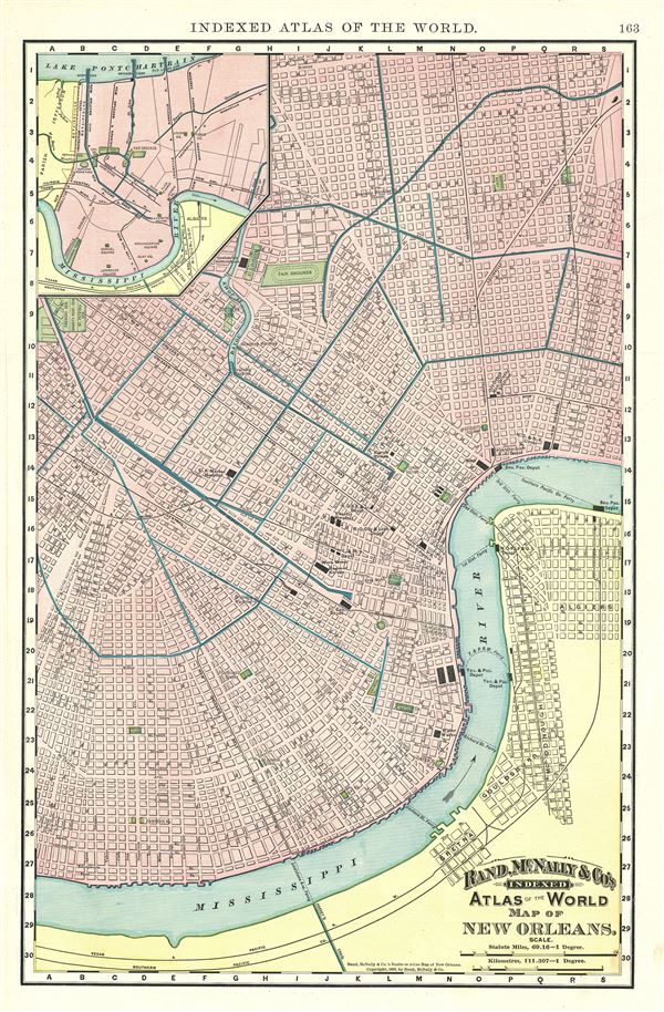
Map of New Orleans.
sold
- Digital Map Information
- Suitable for large format printing
- File Size: 3.17 MB
- File Type: ZIP / TIFF
- ICC color profile embedded
- Delivered instantly via download link
An attractive 1892 map or plan of the city of New Orleans, Louisiana, issued by Rand McNally and Company. It covers the city from the Mississippi River north as far as Monroe St. and from Firemens Cemetery ... (more details)

Map of Boston.
sold
- Digital Map Information
- Suitable for large format printing
- File Size: 19.01 MB
- File Type: ZIP / TIFF
- ICC color profile embedded
- Delivered instantly via download link
This is a beautiful 1891 Rand McNally and Company's map or plan of the city of Boston, Massachusetts. It covers the city from Charlestown and Somerville to Roxbury and Washington Village in the south. Two ... (more details)
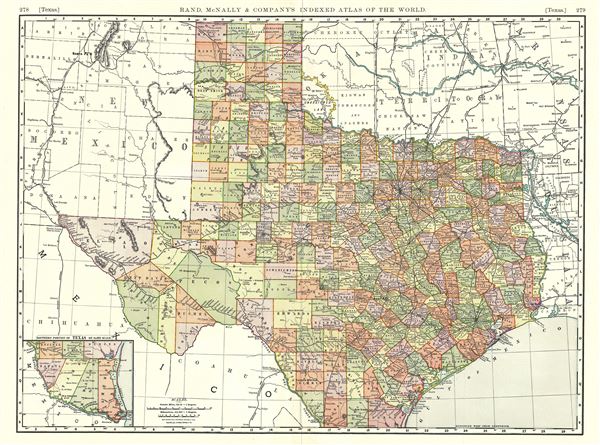
Texas.
sold
- Digital Map Information
- Suitable for large format printing
- File Size: 16.54 MB
- File Type: ZIP / TIFF
- ICC color profile embedded
- Delivered instantly via download link
This is a lovely 1892 Rand McNally and Company map of Texas. It covers the entire state of Texas along with parts of neighboring states. The southern portion of Texas is featured in an inset in the lower ... (more details)