

Northern Circumpolar Map for each Month of the Year. / Southern Circumpolar Map for each Month of the Year.
sold
- Digital Map Information
- Suitable for large format printing
- Full resolution TIFF file
- ICC color profile embedded
- Delivered instantly via download link
This rare hand colored map set depicting the stars of the northern and southern hemispheres was engraved W. G. evans of New York for Burritt's 1835 edition of the Atlas to Illustrate the Geography of the Heavens . The pair of maps illustrates the night sky and ... (more details)

June May April.
sold
- Digital Map Information
- Suitable for large format printing
- Full resolution TIFF file
- ICC color profile embedded
- Delivered instantly via download link
This rare hand colored map of the stars was engraved W. G. evans of New York for Burritt's 1835 edition of the Atlas to Illustrate the Geography of the Heavens . It represents the northern night sky in the months of June, May, and April. Constellations are ... (more details)

Istanbul.
sold
- Digital Map Information
- Suitable for large format printing
- File Size: 9.5 MB
- File Type: ZIP / TIFF
- ICC color profile embedded
- Delivered instantly via download link
An appealing was process color lithograph view of Istanbul, Turkey. Issued around 1890 by Guzel Sanatlar Matbaasi (Fine Arts Printing) of Istanbul. Most likely prepared for this tourist trade, this map offers a beautiful view focused on the Sultanahmet ... (more details)
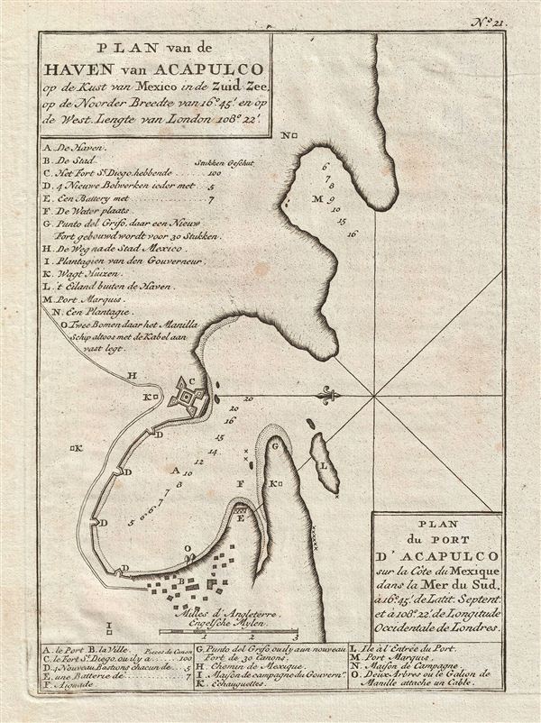
Plan du Port d'Acapulco sur la Cote du Mexique dans la Mer du Sud.
sold
- Digital Map Information
- Suitable for large format printing
- DPI: 300
- File Size: 2.51 MB
- File Type: ZIP / TIFF
- ICC color profile embedded
- Delivered instantly via download link
An uncommon 1751 map of Acapulco, Chile, by the British Admiral George Anson. Oriented to the east, the map details Acapulco Bay and its fortified port. In the 18th century Acapulco was the strategically important starting point for all Spanish trade ... (more details)

Plan d'une Baye de la Cote du Chili, decouverte par un des Vaisseaux d'Avitaillement de l'Escadre de Mr. Anson, en 1741. / Plan van een Baai en Haven aan de Kust van Chili Ontdekt door een Proviand Schip van't Esquader van den ommandeur Anson in de Zuid-Zee 1741.
sold
- Digital Map Information
- Suitable for large format printing
- DPI: 300
- File Size: 3.57 MB
- File Type: ZIP / TIFF
- ICC color profile embedded
- Delivered instantly via download link
An uncommon 1751 map of an unknown Chilean port discovered by the British Admiral George Anson during this seminal circumnavigation of the globe. Oriented to the east, the map shows the port in considerable detail including dramatic shore profiles, ... (more details)
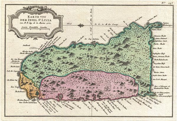
Karte von der Insel St. Lucia.
sold
- Digital Map Information
- Suitable for large format printing
- DPI: 300
- File Size: 4.56 MB
- File Type: ZIP / TIFF
- ICC color profile embedded
- Delivered instantly via download link
An exceptionally fine example of the 1758 Dutch edition of Jacques N. Bellin's map of St. Lucia (St. Lucie), in the Lesser Antilles, West Indies. Oriented to the east, this map covers the entire island of St. Lucia with topography rendered in ... (more details)

Sketch A Showing the Primary Triangularion in Section No. 1 from 1844 to 1859.
sold
- Digital Map Information
- Suitable for large format printing
- File Size: 30.18 MB
- File Type: ZIP / TIFF
- ICC color profile embedded
- Delivered instantly via download link
An attractive example of the U.S. Coast Survey's 1859 triangulation chart of the New england coastline. The chart covers from Narragansett Bay eastward, past Cape Cod, Boston, Portland, and Penobscot Bay as far as Passamaquoddy Bay and Grand ... (more details)

Preliminary Chart of the Entrance to Matagorda Bay Texas.
sold
- Digital Map Information
- Suitable for large format printing
- File Size: 21.19 MB
- File Type: ZIP / TIFF
- ICC color profile embedded
- Delivered instantly via download link
This is an appealing mid-19th century U.S. Coast Survey nautical chart or map of the entrance to Matagorda Bay, Texas. The map covers the Texas coastline from Power Horn Lake and Chocolate Bay eastward as far as Trespalacios Bay, including ... (more details)
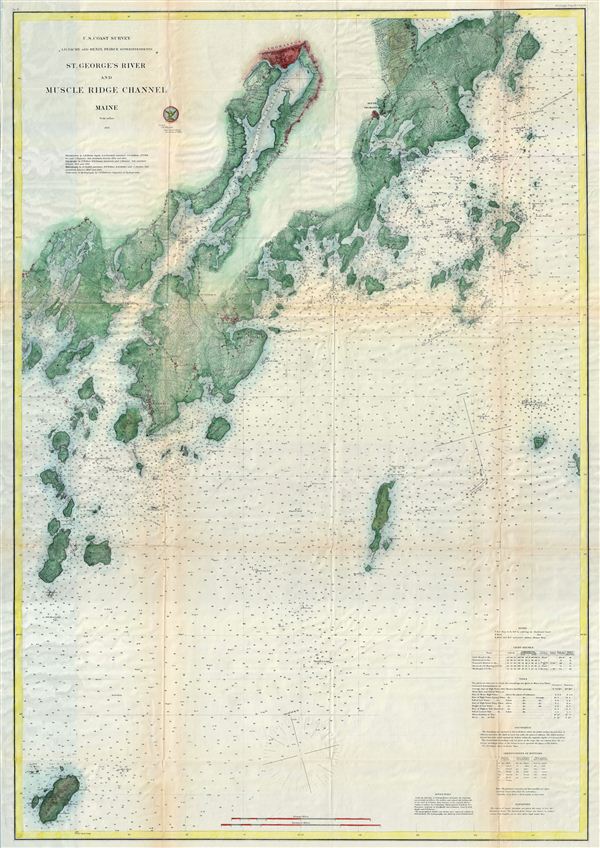
St. George River and Muscle Ridge Channel Maine.
sold
- Digital Map Information
- Suitable for large format printing
- File Size: 35.94 MB
- File Type: ZIP / TIFF
- ICC color profile embedded
- Delivered instantly via download link
This is an appealing mid-19th century U.S. Coast Survey nautical chart or map of St. Georges River and Muscle Ridge Channel, Maine. The map covers the Maine coastline from Friendship Main eastward to Monroe Island, including Thomaston, ... (more details)
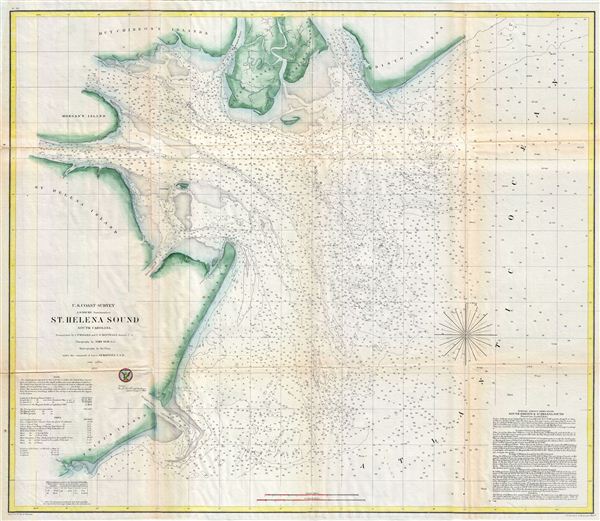
St. Helena Sound South Carolina.
sold
- Digital Map Information
- Suitable for large format printing
- File Size: 25.68 MB
- File Type: ZIP / TIFF
- ICC color profile embedded
- Delivered instantly via download link
This is an appealing mid-19th century U.S. Coast Survey nautical chart or map of St. Helena Sound, South Carolina. The map covers from the edisto Islands south past MorganIsland and St. Helena Island to Fripps Island and Skull Inlet. ... (more details)
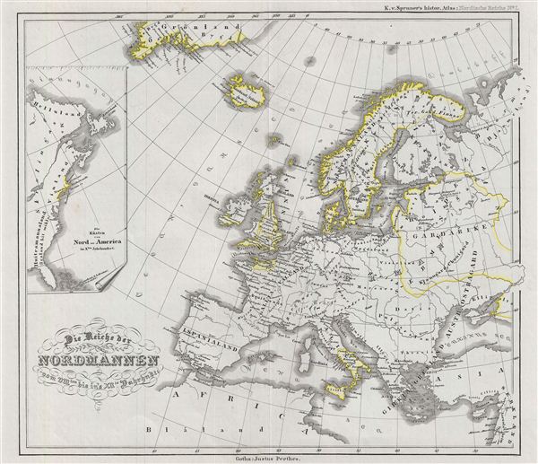
Reiche der Nordmannen vom VIIIten. bis in's XIIte. Jahrdndt.
sold
- Digital Map Information
- Suitable for large format printing
- DPI: 300
- File Size: 6.78 MB
- File Type: ZIP / TIFF
- ICC color profile embedded
- Delivered instantly via download link
This is a fascinating example of Karl von Spruner's 1854 historical map of europe and the empire of the Norsemen (which means 'People from the North,' eventually known as the 'Vikings') from the 8th to the 12th century. The map covers ... (more details)
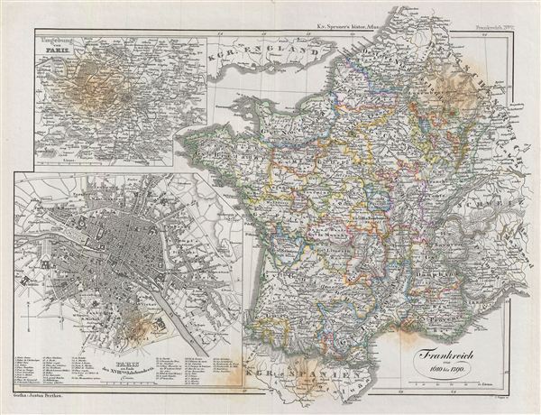
Frankreich von 1610 bis 1790.
sold
- Digital Map Information
- Suitable for large format printing
- DPI: 300
- File Size: 9.67 MB
- File Type: ZIP / TIFF
- ICC color profile embedded
- Delivered instantly via download link
This is a fascinating example of Karl von Spruner's 1854 historical map of France from 1610 to 1790. The map covers France from Calais in the north to the Spanish border in the south. Two inset maps on the top left and bottom left ... (more details)

Scandinavien und Polen nach ihrer kirchlichen Eintheilung bis zur Reformation.
sold
- Digital Map Information
- Suitable for large format printing
- DPI: 300
- File Size: 8.19 MB
- File Type: ZIP / TIFF
- ICC color profile embedded
- Delivered instantly via download link
This is a fascinating example of the Karl von Spruner's 1854 historical map of Scandinavia and Poland until its reformation. The map covers all of Scandinavia including Finland south as far as Poland. Two inset maps in the bottom ... (more details)

Das Reich Kalifen in seiner grossten Ausdehnung.
sold
- Digital Map Information
- Suitable for large format printing
- DPI: 300
- File Size: 8.61 MB
- File Type: ZIP / TIFF
- ICC color profile embedded
- Delivered instantly via download link
This is a fascinating example of Karl von Spruner's 1855 historical map of the Mediterranean during the rule of the Caliphs. The map covers from France to the Sahara Desert in Africa and from Western Arica to Syria, including the ... (more details)

Das Byzantinische Reich bis in das XIte. Jahrhundert.
sold
- Digital Map Information
- Suitable for large format printing
- DPI: 300
- File Size: 9.99 MB
- File Type: ZIP / TIFF
- ICC color profile embedded
- Delivered instantly via download link
This is a fascinating example of Karl von Spruner's 1855 historical map of the Byzantine empire through the 11th century. The map covers Greece, Macedonia, Thracia (modern day Southeast Bulgaria, Northeast Greece, and european ... (more details)

Scandinavien bis zur calmarischen Union, 1397.
sold
- Digital Map Information
- Suitable for large format printing
- DPI: 300
- File Size: 9.97 MB
- File Type: ZIP / TIFF
- ICC color profile embedded
- Delivered instantly via download link
This is a fascinating example of Karl von Spruner's 1855 historical map of Scandinavia during the Kalmar Union of 1397. The map covers Sweden, Norway, Denmark and Finland. The map also features six inset maps detailing ... (more details)
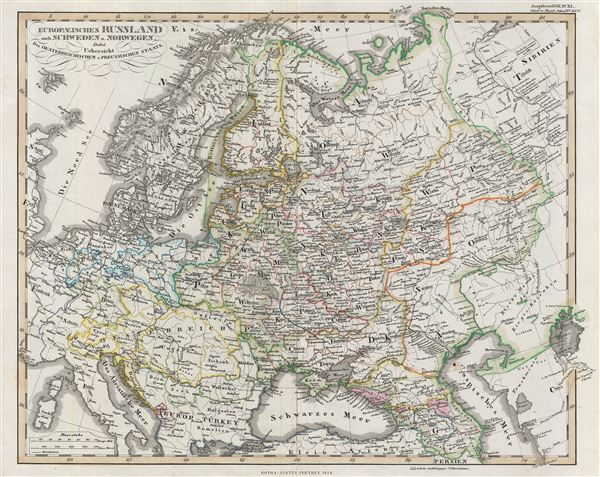
Europaeisches Russland auch Schweden u. Norwegen, Dabei Uebersicht des Oesterreichischen u. Preussischen Staats.
sold
- Digital Map Information
- Suitable for large format printing
- DPI: 300
- File Size: 8.62 MB
- File Type: ZIP / TIFF
- ICC color profile embedded
- Delivered instantly via download link
A fascinating example of the 1854 map of eastern europe. Centered on Russia, the map covers Germany, Norway, Sweden and Denmark and parts of european Turkey, Germany, Prussia, Italy and Austria. Russia at this time was ... (more details)

Ostsee-Laender und Inneres Russland bis Moskau.
sold
- Digital Map Information
- Suitable for large format printing
- DPI: 300
- File Size: 8.99 MB
- File Type: ZIP / TIFF
- ICC color profile embedded
- Delivered instantly via download link
A fascinating example of the 1853 map of the Baltic countries and Russia. The map covers from Sweden and the Baltic Sea to Moscow, including the modern day countries of estonia, Latvia, Lithuania, Belarus, Poland and ... (more details)

Nordwestliches Deutschland (Preuss, Rheinprovinz u. Westphalen, Kgr. Hannover, Oldenburg, Braimschweig, Lippe, Waldeck, die Hessischen Lande, Nassau) Kgr. der Niederlande. Kgr. Belgien.
sold
- Digital Map Information
- Suitable for large format printing
- DPI: 300
- File Size: 8.06 MB
- File Type: ZIP / TIFF
- ICC color profile embedded
- Delivered instantly via download link
This is an 1854 Justus Perthes map of northwestern Germany, Holland, and Belgium. The map covers from the North Sea to the Lower Rhine, including Holland and Belgium, as well as parts of Lower Saxony, Preuss, Rhine Province, Westphalia, Hanover, Oldenburg, Braunschweig, Waldeck, Hesse, and Nassau. (more details)
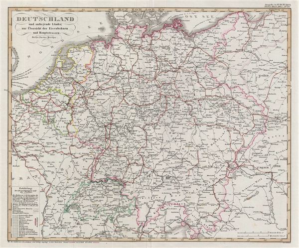
Deutschland und anliegende länder, zur Übersicht der Eisenbahnen und Hauptstrassen.
sold
- Digital Map Information
- Suitable for large format printing
- DPI: 300
- File Size: 6.83 MB
- File Type: ZIP / TIFF
- ICC color profile embedded
- Delivered instantly via download link
A fascinating example of the 1854 Justus Perthes map of Germany and its adjacent countries with an overview of the main roads and railways. This map covers all of Germany from the North Sea southwards as far as ... (more details)