
1850 Horsburgh Map of of the South China Sea: Hong Kong, Philippines, Hainan

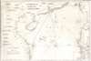

China Sea. Sheet II.
世界上最繁忙、爭議最大的水域。
- Digital Map Information
- Suitable for large format printing
- Full resolution TIFF file
- ICC color profile embedded
- Delivered instantly via download link
世界上最繁忙、爭議最大的水域。
這是一幅詹姆斯·霍斯伯格 (James Horsburgh) 於 1850 年繪製的珍貴中國貿易航海圖,描繪了南海,如今南海是世界上航運最繁忙、爭議最激烈的海域之一。此版本航海圖是最早將香港和維多利亞納入其中的版本之一,香港和維多利亞是第一次鴉片戰爭(1839-1842 年)後建立的英國殖民地。仔細觀察
涵蓋範圍包括福建南部和台灣中部,南至越南中部和菲律賓民都洛島南部,因此涵蓋了:香港、澳門、廣州、菲律賓、海南島、西沙群島、台灣南部(福爾摩沙)以及現代越南的東北海岸。圖中確定了四條往返香港的航線,一條適用於「東北季風」初期,一條適用於「季風」後期,一條途經菲律賓,還有一條是沿海岸線航行的航線,專供「漏水或瘋狂的船隻」使用。左側象限共有23條海岸線剖面圖。出版歷史和人口普查
這張海圖在霍斯伯格1811年繪製的同一區域海圖的基礎上有所擴展,更精確地描繪了中國海岸線,增添了對香港貿易至關重要的航線細節,並納入了更多菲律賓地區。海圖的大部分繪製工作出自丹尼爾·羅斯之手,他被譽為“印度測繪之父”,於1806年至1820年間勘測了中國南方海岸。該海圖最初出版於1823年,此處顯示的是截至1850年的更新和修訂版本。所有版本的海圖都極具收藏價值,十分罕見。Cartographers
James Horsburgh (September 28, 1762 – May 14, 1836) was a Scottish hydrographer and navigator active in the late 18th and early 19th century. Horsburgh was born in Fife, Elie, Scotland, to a humble family. Like many young Scottish men of little means, Horsburgh was destined for a sea-faring life and at just 16 signed on as a cabin boy in a coal trading ship. After many misadventures, including a brief incarceration by the French at Dunkirk, Horsburgh made his way to the West Indies and eventually to Calcutta, India. As the center for British maritime trade in the region, Horsburgh had no difficulty finding work with the British East India Company who maintained an active trade network between India and China. Despite the regular trade, one these voyages to China, aboard the ironically named Atlas, taught Horsburgh just how poorly the East Indies were charted. The 1786 shipwreck of the Atlas, on which he was the First Mate, near Diego Garcia Island proved a pivotal moment Horsburgh's life. He subsequently devoted himself to accurately charting the Indian Ocean and the dangerous Straits of Malacca, Sunda, and Singapore. Many of Horsburgh's charts are the direct results of his own unique survey work on board the Carron and later as captain of the Anna. Horsburgh's work culminated in the publication if his 1809 Directions for Sailing to and from the East Indies, China, New Holland, Cape of Good Hope, and the Interjacent Ports, a monumentally important guide to navigating the waters of the Indian Ocean and the East Indies. His work earned him friendships in London's highest naval and scientific circles, among them Joseph Banks and Alexander Dalrymple. He became a member of the Royal Society in 1806, when he retired from active sailing. When Alexander Dalrymple died in 1810, Horsburgh was appointed to the prestigious position of Hydrographer to the British East India Company where he worked until his death in 1836. Whereas Dalrymple was somewhat indiscriminate regarding the charts he published, Horsburgh was exacting and double checked the veracity of each and every chart that passed through his office. Horsburgh's work with the East India Company elevated the standards of the Hydrographic Department and earned him a Fellowship with the Royal Society. Today's Horsburgh's accomplishments are memorialized by the Horsburgh Lighthouse, near Singapore, and Horsburgh Island. When Horsburgh died most of his work was passed by his children to the Admiralty, which continued to publish updates until roughly 1864. Further Details...
Daniel Ross (November 11, 1780 - October 29, 1849) was a British hydrographer and naval officer active in India and the Far East during the first half of the 19th century. Ross is admiringly referred to as 'The Father of the Indian Surveys.' He was born in Jamaica, the illegitimate son of Hercules Ross (1745 - December 25, 1816), a powerful Jamaican-English merchant, privateer ship owner, and naval price agent. His mother was Elizabeth Foord, a quadroon slave who Hercules later freed. Ross joined the Bombay Marine in 1795. From 1806 to 1820 he was assigned to survey the coast of China from Vietnam to Macao. In 1822 he was elected a fellow of the Royal Society. By 1823 he had been appointed Marine Surveyor General of Calcutta, a position he held until he resigned in 1833. Afterwards he retired to Bombay (Mumbai) where in 1838 he was appointed President of the Bombay Geographical Society. He retained the position until retiring in ill-heath in 1849. He is the half-brother of sportsman and photography pioneer Horatio Ross. Further Details...
Condition
Good. Infill to upper left corner and at top center. Slight soil bands left and right side. Else a beautiful clean example.
References
Library of Congress, Map Division, G7822.C5 1823 .H6.