
1926 Admiralty Nautical Map of North Vietnam: Hanoi, Ha Long Bay

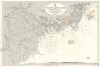

Kua Lakh to Kao Tao Islands Including The Delta of the Song Ka.
One of the most beautiful places on Earth.
- Digital Map Information
- Suitable for large format printing
- File Size: 76.86 MB
- File Type: ZIP / TIFF
- ICC color profile embedded
- Delivered instantly via download link
One of the most beautiful places on Earth.
This is a 1926 British Admiralty nautical chart or maritime map of northeastern Vietnam in the vicinity of Hanoi and Ha Long Bay. Today, this area is regarded as one of the most beautiful places on Earth.A Closer Look
Highly detailed, myriad depth soundings are indicated throughout, with particular attention paid to Ha Long Bay. The mouth of the Bach Dang River is also particularly well charted. Lights situated at the river's mouth are marked with yellow dots, allowing them to be easily spotted by anyone using the chart. Roads and railways are also illustrated. Two pastedowns in the upper-right indicate areas of significant revision.Historical Context
The map depicts the area from Hanoi to the Thanh Lan Islands and from north of Cam Pha to Bach Long Vi Island. In the early 20th century, Haiphong emerged as the crown jewel of French maritime strategy in Indochina, serving as the primary gateway for the colonial economy. Founded on the mudflats of the Cua Cam River, the city was meticulously engineered by the French to be a modern port city, complete with European-style boulevards, a sophisticated rail network connecting to Kunming, Yunnan, China, and heavy industrial infrastructure, such as cement works. By the 1920s, it had become the second most important port in French Indochina after Saigon, acting as the vital funnel through which northern Vietnam's raw materials, including coal from nearby Quang Ninh, were exported to the global market, and through which French-manufactured goods were imported. This strategic position made Haiphong not just a commercial hub, but a pivotal military and administrative outpost that solidified French grip over the Tonkin region and projected French influence across the Southeast Asian littoral and into southern China.Although the South China Sea is currently a hotbed of international disputes between numerous countries, particularly with regard to territorial control over different islands and archipelagos, Bach Long Vi Island is not one of these islands. China gave Bach Long Vi to the city of Haiphong in 1957, and it remains a district of Hai Phong.
Census and Publication History
This map was created by the British Admiralty, engraved by Edward Weller, and published in 1926. The first edition was published by the Admiralty on March 19, 1894, and several editions were published in the intervening years. No records of this chart are cataloged in the OCLC.Cartographers
The British Admiralty Office (1795 - Present) or the United Kingdom Hydrographic Office refers to the Branch of the English government that is responsible for the command of the British Navy. In 1795 King George III created the United Kingdom Hydrographic Office, known in short as the U.K.H.O., to provide top notch nautical charts to the vast Royal Navy. Prior the founding of the Admiralty the surveying and creation of nautical charts was primarily a commercial venture wherein the cartographer himself, more of than not, actually financed the printing of his own material. The great navigator Cook himself is known to have scrambled for funds to publish his own seminal charts - the most important and advanced of the period. The system of privately funded nautical mapping and publishing left vast portions of the world uncharted and many excellent charts unpublished. King George III, responding significant loss in trade revenue related to shipwrecks and delay due to poor charts, recognized the need for an institutionalized government sponsored cartographic agency - the Admiralty. The first head of the Admiralty, a position known as Hydrographer, was the important cartographer Alexander Dalrymple. Dalrymple started by organizing and cataloging obtainable charts before initiating the laborious process of updating them and filling in the blanks. The first official Admiralty Chart appeared in 1800 and detailed Quiberon Bay in Brittany. By 1808 the position of Hydrographer fell to Captain Thomas Hurd. Hurd advocated the sale of Admiralty charts to the general public and, by the time he retired in 1829, had issued and published some 736 charts. Stewardship of the organization then passed to Rear Admiral Sir Francis Beaufort. It was under Beaufort's administration that the Admiralty truly developed as a "chart making" as opposed to a "chart cataloging" institution. Beaufort held his post from 1829 to 1854. In his 25 years at the Admiralty Beaufort created nearly 1500 new charts and sponsored countless surveying and scientific expeditions - including the 1831 to 1836 voyage of the H.M.S. Beagle. By 1855 the Admiralty's chart catalog listed some 1,981 charts. Further Details...
Edward Weller (July 1, 1819 - 1884) was a cartographer and engraver based in London. Weller was a nephew of another well-known map publisher Sidney Hall (1788 - 1831), who gave him 50 Pounds to pay his apprenticeship fees. He engraved for many prominent mapmakers and was active enough in the community to be recommended for membership to the Royal Geographical Society in 1851 on the recommendation of John Arrowsmith, among others. He eventually inherited the Sidney Hall map business which led him to follow Arrowsmith as the unofficial geographer to the Royal Geographical Society. Weller was among the first map printers in London to embrace lithography. His best known work appears in Cassell's Weekly Dispatch Atlas, published in monthly segments for subscribers of the 'Weekly Dispatch' newspaper. This collection of maps eventually grew to include much of the known world. Published in various editions from 1855 through the early 1880s. Weller died in May of 1884, leaving behind a successful business and an unhappy widow. His son, Francis Sidney Weller (1849 - 1910), followed in his father's footsteps and continued the family map business. The atlas Mackenzie's Comprehensive Gazetteer of England and Wales was published in 1894 and bore F. S. Weller's signature on the maps. Further Details...
Condition
Very good. Even overall toning. Light soiling.