
1866 Voisin Folding Map of the Suez Canal, Egypt

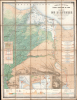
Compagnie Universelle du Canal Maritime de Suez Carte de l'Isthme.
Earliest Official Map of the Suez Canal.
- Digital Map Information
- Suitable for large format printing
- Full resolution TIFF file
- ICC color profile embedded
- Delivered instantly via download link
Earliest Official Map of the Suez Canal.
This is a 1866 large-format chromolithographic folding map issued by the Compagnie universelle du canal maritime de Suez, under the direction of its chief engineer, François-Philippe Voisin. Published in 1866, three years before the canal's completion, this rare first edition of the official canal map is among the most visually compelling and technically detailed maps ever made of the project. During World War I (1914 - 1918), the Imperial German Army deemed it so accurate and useful that it issued a faithful pirated edition for commanders planning an assault on the canal.A Closer Look
The main map covers the eastern half of the Nile Delta from Cairo to Damietta, the full Suez Isthmus separating the Mediterranean from the Red Sea, and the western extremities of the Sinai Peninsula. The canal itself is marked by a red line running south from Port Said on the Mediterranean through Lake Timsah and the Great Bitter Lake to the port of Suez on the Red Sea, with distances in kilometers marked at intervals along its course. Cities and towns are indicated, along with the branching channels of the Nile Delta, and the desert terrain beyond, rendered in gradients of shading. Roads and the railway network are carefully delineated, including the Cairo-Suez Railway, completed in 1858 by Robert Stephenson, which proved essential to the canal's construction. The freshwater canal running from the Nile to Ismailia and down to Suez, built primarily to supply drinking water and concrete-mixing water to the workforce, is also shown, as are the traces of the ancient canals that had crossed the isthmus in antiquity.The composition is enriched by an array of insets. On the left, a map of the location where the freshwater canal branches from the Nile is accompanied by cross-sections of the sluices (écluses) of the freshwater canal and the Suez Canal. On the right, six cross-sectional profiles taken at key points along the route exhibit the channel's depth and construction. Three detailed town plans in the lower portion depict Port Said, Ismailia, and Suez with their port infrastructure. Most remarkable of all is the large geological profile occupying the base of the sheet, which records eleven distinct strata in brilliant color, the first comprehensive scientific geological survey of the isthmus, made possible by the canal's excavation.
Suez Canal
The Suez Canal was constructed by the Suez Canal Company between 1859 and 1869, officially opening to maritime traffic on November 17, 1869. The canal cuts through the western Sinai Peninsula between the Mediterranean at Port Said and the Red Sea at Suez. The canal's completion allowed for significantly faster communication between European ports and the lucrative markets of Asia, as it nullified the need to round Africa.Work began on April 25, 1859, shortly after the developer Ferdinand de Lesseps obtained a concession from Sa'id Pasha, the Khedive of Egypt and Sudan. He created an international commission consisting of 13 experts from 7 countries to construct the canal. Much of the construction force was conscripted labor under the corvée system, which was common in Egypt until 1882, when it was outlawed. The British initially opposed the canal out of fear that it would disrupt English dominance of maritime trade. However, in 1875, when Said Pasha's successor, Isma'il Pasha, ran up excessive debt, the British government acquired a 44 percent share of the Suez Canal Company (initially known as Compagnie universelle du canal maritime de Suez). In 1888, the canal was declared a neutral zone under British protection; it was nationalized by Gamal Abdel Nasser in 1956, leading to the Suez Crisis that year. Combined with the completion of the Transcontinental Railroad in the United States six months earlier and a rail link across the Indian Subcontinent the following year, the Suez Canal signaled a new era of long-distance transportation. It quickly became the subject of related cultural production, such as Jules Verne's Around the World in Eighty Days (1872).
Pirated German Edition during World War I
In 1917, more than 50 years after its publication, the present map's utility was demonstrated in the most dramatic fashion. The Imperial German Army's cartographic department, the Stellvertretender Generalstab der Armee, issued a pirated edition at the beginning of that year for use by German and Ottoman commanders planning a renewed assault on the canal from their bases in Palestine; the Ottomans already having tried and failed to seize the canal in 1915. The reason for such attempts is obvious: if successful, the Ottomans would have severed Britain's lifeline to India, severely curtailing the flow of troops and supplies to the Western Front and Britain. The pirated edition was rendered obsolete almost immediately, as a British imperial offensive pushed the front eastward into Palestine by the end of February 1917, removing the canal from danger for the remainder of the war.Chromolithography
Chromolithography, sometimes called oleography, is a color lithographic technique developed in the mid-19th century. The process uses multiple lithographic stones, one for each color, to yield a rich composite effect. Generally, a chromolithograph begins with a black basecoat upon which subsequent colors are layered. Some chromolithographs used 30 or more separate lithographic stones to achieve the desired effect. Chromolithograph color can be blended for even more dramatic results. The process became extremely popular in the late 19th and early 20th centuries when it emerged as the dominant method of color printing. The vivid color of chromolithography made it exceptionally effective for advertising and propaganda.Publication History and Census
This map was published in 1866 by the Compagnie universelle du canal maritime de Suez, under the direction of its chief engineer, François-Philippe Voisin, based on the work of Engineer-Hydrographer Eugène-Hyacinthe Larousse. It was drawn by Charles Lecocq de la Frémondière and printed in Paris by the firm of Eugène Andriveau-Goujon, with lithography by Erhard Schièble and printing by the Imprimerie Lemercier. The 1866 first edition of the map is held at the Library of Congress, Yale University, Gonzaga University, the University of Wisconsin-Milwaukee, and Harvard University. The map in any edition has only appeared on the market a handful of times in the past 25 years.Cartographers
François Philippe Voisin (May 20, 1821 - March 17, 1918) was a French engineer best known for playing a leading role in the design and construction of the Suez Canal. Voisin was born in Versailles and attended the prestigious École Polytechnique, after which he worked for the Corps des Ingénieurs des Ponts, des Eaux et des Forêts. In 1861, he went to work for the Compagnie universelle du canal maritime de Suez (Suez Canal Company) and by 1865 had risen to Directeur des travaux (i.e. Chief Engineer), second only to Ferdinand de Lesseps in the company hierarchy. After the canal's completion, Voisin returned to France to teach at the École des Ponts et Chaussées. In 1880, he was made Director of Public Works in Algeria (then part of France), and in 1884 Voisin became a member of the Board of Directors for the Suez Canal Company, rising to Vice Chairman in 1893. Voisin was widely celebrated as one of the great French engineers of his generation and received various awards in the latter half of his long life, including receiving the title of Bey from the Khedivate of Egypt, leading to his often being referred to as Voisin-Bey. In 1854, Voisin married Mathilde Aronssohn, the daughter of King Louis-Philippe's physician, but unfortunately Mathilde died in 1865 when a cholera epidemic tore through the canal zone. Further Details...
Eugène-Hyacinthe Larousse (August 17, 1832 - March 30, 1896) was a French engineer best known for his work on the Suez Canal and related projects. He was born in Paris and attended the École Polytechnique. After graduating, he worked as a hyrographic engineer for the French navy before accompanying engineer Aristide Lieussou (1815 - 1858) to begin preliminary explorations of the Suez Canal, following the granting of a concession to Ferdinand de Lesseps in 1854. Larousse undertook some of the earliest surveys plotting out the modern harbors of Port Said and Suez, and produced the most comprehensive hydrographic survey of the canal during its construction. After the completion of the canal, he returned to France to work in the Gironde and later explored the possibility of a railway tunnel beneath the English Channel (La Manche). From 1878, he briefly worked as the administrator of the Compagnie du chemin de fer et du port de la Réunion. From 1880 to 1887, he served on the High Consultative Commission of the Panama Canal Company. In 1866, he was made a Chevalier of the Légion d’honneur. He was married to one Mademoiselle Guébhard, with whom he had one daughter. Further Details...
Eugène Andriveau-Goujon (1832 - 1897) was a map publisher and cartographer active in 19th century Paris. The firm was created in 1825 when Eugène Andriveau married the daughter of map publisher Jean Goujon - thus creating Andriveau-Goujon. Maps by Andriveau-Goujon are often confusing to identify as they can be alternately singed J. Goujon, J. Andriveau, J. Andriveau-Goujon, E. Andriveau-Goujon, or simply Andriveau-Goujon. This refers to the multiple generations of the Andriveau-Goujon dynasty and the tendency to republish older material without updating the imprint. The earliest maps to have the Andriveau-Goujon imprint were released by Jean Andriveau-Goujon. He passed the business to his son Gilbert-Gabriel Andriveau-Goujon, who in 1858 passed to his son, Eugène Andriveau-Goujon, under whose management the firm was most prolific. Andriveau-Goujon published numerous fine pocket maps and atlases throughout the 19th century and often worked with other prominent French cartographers such as Adrien-Hubert Brué (1786 - 1832) and Victor Levasseur (1800 - 1870). The firm's stock was acquired by M. Barrère in 1892, who operated it until c. 1930, when it passed on to P.H. Barrère (presumably his son). In 1933, the firm was merged to become Girard et Barrère and in the post-World War II period operated as Girard, Barrère et Thomas until it was purchased by Cartes Taride in 1974. Further Details...
Georges Erhard Schièble (1823 – November 23, 1880) was a German printer active in Paris during the middle to late 19th century. Erhard was born in Forchheim, Baden-Württemberg, and relocated to Paris in his 16th year, where he apprenticed under his cousin, an engraver and mapmaker. In 1852, after 6 years with the Royal Printing Office, he started his own business. Around this time, he also became a naturalized French citizen. From his offices on Rue Bonaparte, he produced several important maps, and a detailed topography of Gaul for Napoleon III's History of Julius Caesar. In 1865 he took on larger offices expanding his operations to include a lithographic press. He was among the first to introduce printed color maps and pioneered photo-reduction, including the process known as Erhard reproduction. After Erhard's death in 1880, the firm was taken over by his sons and run under the imprint of 'Erhard Frères' until 1911. Further Details...
Rose-Joseph Lemercier (June 29, 1803 - 1887) was a French photographer, lithographer, and printer. One of the most important Parisian lithographers of the 19th century, Lemercier was born in Paris into a family of seventeen children. His father was a basket maker, and he even began working as a basket maker at the age of fifteen, but Lemercier was drawn to lithography and printing and soon entered into an apprenticeship with Langlumé, where he worked from 1822 until 1825. After working for a handful of other printers, Lemercier started his own firm in 1828 at 2, rue Pierre Sarrazin with only one printing press. He subsequently moved a few more times before arriving at 57, rue de Seine, where he founded the printing firm Lemercier and Company. He created the firm Lemercier, Bénard and Company in 1837 with Jean François Bénard. Lemercier bought out Bénard's share in the firm in 1843 and, since his two sons died at a young age, he decided to bring his nephew Alfred into the business beginning in 1862, who would progressively take on more and more responsibility in running the firm. Between 1850 and 1870, Lemercier's firm was the largest lithographic company in Paris. The firm began to decline in prestige in the early 1870s, and, after Lemercier's death in 1887, its descent only quickened. It is unclear when the firm closed, but Alfred directed the firm until his death in 1901. Further Details...
Condition
Very good. Light foxing. Laid down on linen, original. Some verso reinforcement to old linen fold lines.
References
Library of Congress G8302.S9 1866 .C6. OCLC 705273137, 41590566.