
Ackermann (sold)

Ackermann (1795 - 199x) was a British publishing firm founded by Rudolph Ackermann (April 20, 1764 - March 30, 1834). First known as R. Ackermann and Company, Ackermann's three sons took over the business when their father retired. The firm was known as A. Ackermann and Son in the early 20th century and had offices in London, Paris, New York, and Chicago. Their New York office was exceptionally prolific, issuing work for both the private and government sectors. Ackermann was acquired in late 1990s and the imprint resurrected.
One of the earliest obtainable views of Honolulu.
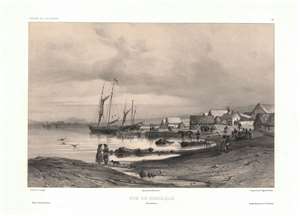
Vue de Honolulu. Iles Sandwich.
sold
- Digital Map Information
- Suitable for large format printing
- Full resolution TIFF file
- ICC color profile embedded
- Delivered instantly via download link
One of the earliest obtainable views of Honolulu, Hawaii, this c. 1840 image was drawn by Barthélemy Lauvergne. Lauvergne was one of several artists accompanying the 1836 - 1837 Auguste-Nicolas Vaillant (1793 - 1858) circumnavigation. The scientific expedition arrived in Hawaii on September 28, 1836 and stayed through October 11. It is safe to assume that Lauvergne sketched this view in early October 1836. The view reveals the ragtag European coastal village set beside the tiny harbor of Kou. Note the European style buildings - as opposed to traditional high roofed Hawaiian thatched structures. Two sailing ships are anchored just offshore. Within 20 years, this small settlement would grow to become the economic hub of the entire north Pacific. In 1850, there are records of more than 100 whaling ships crowding the harbor and 3000 drunken sailors wandering the rough streets in search of … the things for which drunken sailors search. (more details)
One of the earliest obtainable views of Singapore.
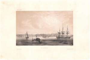
Vue de Sincapour.
sold
- Digital Map Information
- Suitable for large format printing
- DPI: 600
- File Size: 26.17 MB
- File Type: ZIP / TIFF
- ICC color profile embedded
- Delivered instantly via download link
One of the earliest obtainable views of Singapore, this is a rare c. 1845 chromolithograph by Barthélémy Lauvergne, one of the resident artists on the Bonite Expedition (1836 - 1837), a French scientific and diplomatic circumnavigation. It presents the British colony in its early days of development as a bustling port and meeting point of cultures. (more details)
The Chicago Water Tower - one of the few buildings to survive the Great Chicago Fire.
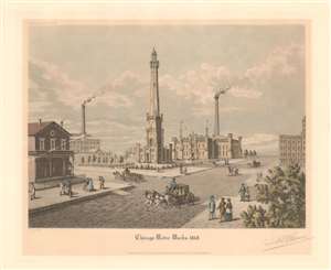
Chicago Water Works 1868.
sold
- Digital Map Information
- Suitable for large format printing
- File Size: 11.79 MB
- File Type: ZIP / TIFF
- ICC color profile embedded
- Delivered instantly via download link
This is a 1929 Raoul Varin aquatint view of the Chicago city waterworks and water tower as it appeared in 1868. Located on modern-day Michigan Avenue (called Pine Street in 1868), the Water Tower and the pump house survived the Great Chicago Fire of October 8-10, 1871. It stands 182.5 feet tall and housed a 138-foot high standpipe while it was operational. When Pine Street was widened in 1918, the plans were revised to give the Water Tower and the Chicago Avenue Pumping Station a featured location. (more details)
Signed view of the Chicago River and the Wells and Clark Street Bridges.
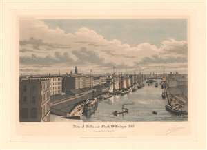
View of Wells and Clark St. Bridges 1861.
sold
- Digital Map Information
- Suitable for large format printing
- File Size: 14.86 MB
- File Type: ZIP / TIFF
- ICC color profile embedded
- Delivered instantly via download link
This is a 1929 Raoul Varin aquatint view of the Wells and Clark Street Bridges across the Chicago River in Chicago, Illinois. Looking west along the Chicago River, the Chicago Tobacco Works and the Western Transportation Company appear in the foreground. Boats line the Chicago River, and the span of the Clark Street Bridge is turned horizontally to allow a boat to pass. The Wells Street Bridge still spans the river and has not yet been swung upward for the boat. The top of the courthouse is visible over the buildings, along with the steeples of several churches. (more details)
A view of the first Rush Street Bridge that was destroyed three years after it opened.
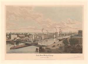
Rush Street Bridge Chicago in the Year 1861.
sold
- Digital Map Information
- Suitable for large format printing
- File Size: 13.09 MB
- File Type: ZIP / TIFF
- ICC color profile embedded
- Delivered instantly via download link
This is a 1929 Raoul Varin aquatint view of the Rush Street Bridge. The bridge occupies the foreground and a large crowd of people gather on the near end of the bridge. Buildings line the far bank, McCormick's Reaper Factory and the sugar refinery both identified. Sailing ships line both banks of the Chicago River and a steamship, name the Comet steams away from the bridge toward Lake Michigan. (more details)
The Magnificent Mile.
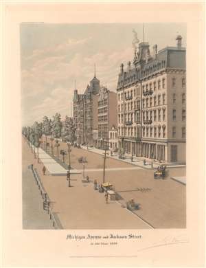
Michigan Avenue and Jackson Street in the Year 1889.
sold
- Digital Map Information
- Suitable for large format printing
- File Size: 12.8 MB
- File Type: ZIP / TIFF
- ICC color profile embedded
- Delivered instantly via download link
This is a 1929 Raoul Varin aquatint view of the Leland Hotel at the corner of Michigan Avenue and Jackson Street, on the Magnificent Mile. Trees line Michigan Avenue and pedestrians walk along the sidewalks. Horse-drawn carriages make their way up and down Michigan Avenue transporting Chicago's elite. The Leland Hotel appears prominently at right. (more details)
Lake Shore Drive (then) 1889 and (now) 1934.
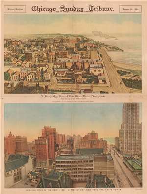
A Bird's-Eye View of Lake Shore Drive Chicago 1883 From the top of the Water Tower. Looking toward the Drive, 1934: A Present-Day View from the Water Tower.
sold
- Digital Map Information
- Suitable for large format printing
- File Size: 22.1 MB
- File Type: ZIP / TIFF
- ICC color profile embedded
- Delivered instantly via download link
This is a 1934 Chicago Sunday Tribune bird's-eye view of Lake Shore Drive in Chicago. The two separate views, presented on a single broadsheet, both look north on Lake Shore Drive from the Water Tower, but at different points in history, 1889 and 1934, respectively. The upper view is an aquatint issued by Raoul Varin in 1889. The bottom view is a photograph taken by the Tribune from the Water Tower in 1934. The differences provide an striking visual summary of Chicago's urban progression during the first few decades of the 20th century. (more details)