
Allard, Carel (sold)

Carel Allard (1648 - 1709) was a Dutch art dealer, cartographer and engraver. In the 17th century, the Allard family published various maps in Amsterdam. Carel was the son of mapmaker and engraver Hugo Allard. He appears to have been somewhat prolific and successful than his father: he produced in his lifetime a 1697 Atlas Minor, the c. 1705 Atlas Major and several other works with engraved plates, as well as continuing to publish from his father's stock. He passed along his copperplates to his son Abraham (1676-1725) prior to going bankrupt in 1706.
An Unrecorded First State of this Classic Dutch Map of Africa.
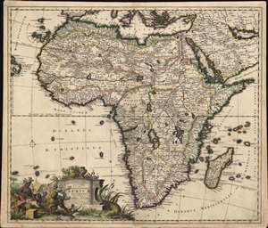
Novissima et perfectissima Africae descriptio.
sold
- Digital Map Information
- Suitable for large format printing
- Full resolution TIFF file
- ICC color profile embedded
- Delivered instantly via download link
This is a rare, newly-identified first state of Carel Allard's c. 1696 map of Africa. Most examples available on the market - themselves scarce - were included in Allard's 1697 Atlas Minor; both known earlier states were produced no later than 1697 and possibly as early as 1683, and were separately-issued maps, sometimes included in composite atlases and consequently of significantly greater rarity than comparable maps appearing in regularly-published atlases. (more details)
Scotland, the Hebrides, and the Orkney Islands Beautifully Embellished.
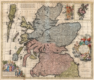
Novissima Regni Scotiæ Septentrionalis et Meridionalis Tabula divisae in Ducatus, Comitatus, Vice-Comitatus, Provincias, Praefecturas, Dominia et Insulas.
sold
- Digital Map Information
- Suitable for large format printing
- DPI: 600
- File Size: 69.71 MB
- File Type: ZIP / TIFF
- ICC color profile embedded
- Delivered instantly via download link
This is Carel Allard's 1697 map of the Kingdom of Scotland, in its 1725 Covens and Mortier edition. Between the superb engraving of the map and its ornate cartouches, it is one of the most richly decorative maps of Scotland produced in that era. (more details)