
D'Avila, Juan Francisco (sold)

Juan Francisco d'Avila (1682 - 1733) was a Spanish colonial missionary and Jesuit lay brother active in Paraguay and Argentina in the early 17th century. D'Avila was born in Buenos Aires. He spent 10 years between 1712 and 1722 mapping the Jesuit Reductions in the Rio de La Plata Basin. Little else has been recorded of his life.
Earliest Acquirable Issue of D'Avila's Paraguay.
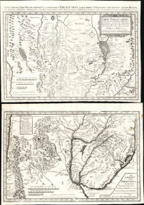
Ober-Paraguarien : Nebst denen Länderen Baures, Tschikiten, Schareyes, Paraguas, Toromonas, Moschos, Ytonamas etc. samt einem Theil dern Königreichen Tschili und Peru etc. etc/ Die Landschaft nider-Paraguaria : Samt den Ländern Tucuman, Tscharvas, Tschaco, Mocobis, und einem Theil des Königreichs Tschili ec.
sold
- Digital Map Information
- Suitable for large format printing
- Full resolution TIFF file
- ICC color profile embedded
- Delivered instantly via download link
This is Joseph Stöcklein's 1728 map of central South America illustrating the Jesuit province of Paraguay and the surrounding regions, including present-day Uruguay, parts of Argentina, and Brazil. This two-sheet map is one of the earliest iterations of the 1722 map produced by Juan Francisco D'Avila, the most complete map of the Rio de la Plata watershed available at the time. The earliest printed D'Avila map was engraved by Giovanni Petroschi and published in Rome in 1726. In his Cartografia Jesuttica del Rio de la Plata, scholar Guillermo Furlong Cardiff hailed this unacquirable map as 'without doubt the most complete and most comprehensive map undertaken by the Jesuits up to the middle of the eighteenth century.' (Buenos Aires, 1936, p. 44). The present map, engraved in 1728 and published in the 1729 installment of Stöcklein's collection of Jesuit Relations, is the earliest acquirable version of Dávila's work. (more details)
Scarce Map of La Plata.
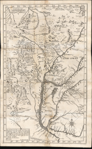
Descripción de las Provincias del Chaco, y confinantes segun las relaciones modernas, y noticias aquiridas por diversas entradas de los Missioneros de la Companía de Iesus que se han hecho en este siglo de 1700.
sold
- Digital Map Information
- Suitable for large format printing
- File Size: 14.5 MB
- File Type: ZIP / TIFF
- ICC color profile embedded
- Delivered instantly via download link
This rare 1733 Pedro Lozano map of central South America, engraved by Giovanni Petroschi, is the first appearance of Antonio Machoni's amendments to Juan Francisco D’Avila's foundational map of the La Plata region. These changes were made both to the Chaco region on the west bank of the Paraguay River (the location of Machoni's missionary work) and the southern coast of what would become Uruguay. The region was a key theatre of Jesuit missionary activity; consequently, the Jesuits produced the first accurate maps of the complex river systems emptying into the Rio de la Plata. The present work illustrates the process of revision over the 18th century, with the contributions of key cartographers and missionaries. (more details)
…most complete and most comprehensive map undertaken by the Jesuits up to the middle of the eighteenth century. - Furlong
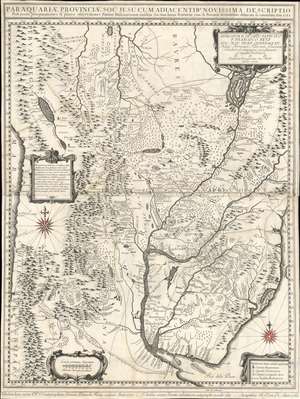
Paraquariae Provinciae Soc. Jesu Cum Adiacentibus Novissima Descriptio Post iterata peregrinationes et plures observationes Patrum Missionariorum . . . 1732.
sold
- Digital Map Information
- Suitable for large format printing
- Full resolution TIFF file
- ICC color profile embedded
- Delivered instantly via download link
A rare example of the 1760 edition of Jesuit lay brother Juan Francisco Dávila's map of Paraguay, Uruguay, and La Plata. The map details the Río de la Plata basin, presenting the most advanced cartographic representation of the region available at the time of publication. Coverage extends from the Pantanal region and the northern extremis of the Paraguay River, the fictional Laguna de Xarayes, to Buenos Aires, Montevideo, and the mouth of the Río de la Plata. Focus is on the Jesuit Reductions, inland Jesuit missionary settlements of extreme wealth and prosperity that dominated the inland river systems between the Paraná River and the foothills of the Andes. (more details)