
Haas, Jonas Carl Frederik Washer (sold)

Jonas Carl Frederik Washer Haas (1720 - April 10, 1775) was a Nuremberg-born artist and engraver active in Copenhagen, Denmark, in the middle to late 18th century. Haas was born in Nuremberg in 1720. After several years in Hamburg, Haas relocated to Copenhagen along with several other of his fellow artists, including Johan Martin Preisler and Carl Marcus Tuscher. In 1755, Haas was appointed official engraver for the University of Copenhagen. In addition to numerous portraits, he engraved maps for Johan Jacob Bruun's Novus Atlas Daniæand, and vignettes of Frederik Ludvig Norden's Travels. In Hamburg, he had married Anna Rosine Fritsch, the daughter of a fellow engraver, with whome he had four children. Three of his sons, Georg, Meno, and Peter were also engravers. Haas is interred at St. Peter's church cemetery.
One of the earliest obtainable specific maps of Greenland.
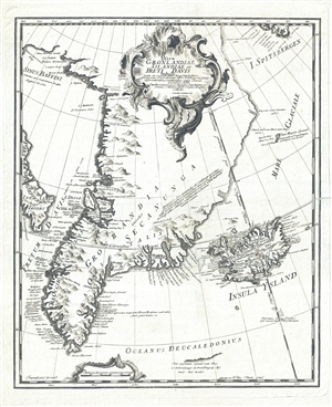
Nova Gronlandiae Islandiae et Freti Davis tabula : quam ex recentissimis, usque selectissimis peritiorum Navarchorum, item Dannicae missionis observationibus, relationibus atque diariis, peculiari studio.
sold
- Digital Map Information
- Suitable for large format printing
- DPI: 300
- File Size: 4.25 MB
- File Type: ZIP / TIFF
- ICC color profile embedded
- Delivered instantly via download link
A scarce 1746 map of Greenland drawn to illustrated Johann Anderson's study on the North Atlantic, Nachrichten von Island, Grønland und der Strasse Davis . This is one of the earliest specific maps of Greenland. It covers from the Baffin Sea and Spitsbergen to ... (more details)
Extremely rare and impressively large 18th century map of Ibiza, Spain.
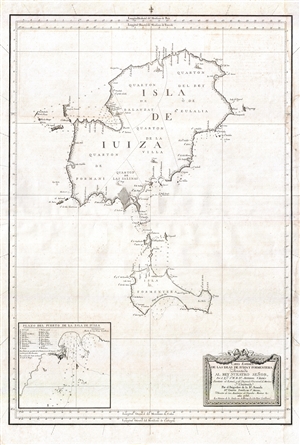
Carta Esférica de las Islas de Iuiza y Formentera;Presentada al Rey Nuestro Señor, Por el Emo. Sr. Bº. Fr. Dn. Antonio Valdés, Secretario de Estado, y del Despacho Universal de Marina;Y Construida Por el Brigadier de la Rl. Armada Dn. Vicente Tofiño de Sn. Miguel, Director de las Academias de Guardias Marinas &c.
sold
- Digital Map Information
- Suitable for large format printing
- DPI: 300
- File Size: 13.96 MB
- File Type: ZIP / TIFF
- ICC color profile embedded
- Delivered instantly via download link
An extremely rare large scale 1786 Spanish nautical chart detailing the Balearic Islands of Ibiza and Formentera by the famed hydrographers Vincente Tofiño de San Miguel and Antonio Valdés y Fernández Bazán. The map covers both islands in full with light ... (more details)