
Lodge, John (sold)

John Lodge (1735-1796) was a British engraver, map seller, draughtsman and stationer active in London from roughly 1755 to the late 18th century. Lodge, born in London, was apprenticed to Thomas Jefferys, one of the most prominent and prolific map publishers and engravers of his day. He produced several maps for The Gentleman's Magazine and The Political Magazine and other publications. He also engraved book-illustrations, portraits and botanical plates and taught etching and engraving. Around the 1780's, he is believed to have lived to Dublin, where he did a significant amount of engraving work for Dublin booksellers. Lodge was survived by his wife Ann, to whom he left his entire estate, and his son John Lodge, who was also an engraver.
A detailed city map of Dublin from the late 18th century.
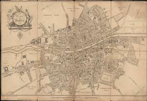
A Plan of Dublin.
sold
- Digital Map Information
- Suitable for large format printing
- DPI: 600
- File Size: 15.91 MB
- File Type: ZIP / TIFF
- ICC color profile embedded
- Delivered instantly via download link
This is a 1780 Robert Pool and John Cash city map or plan of Dublin, Ireland. The map depicts the city from the Royal Hospital to the Marine School and from Eccles Street to a bridge of 'part of the new canal'. Highly detailed, myriad streets are labeled throughout Dublin, some of which are rather small alleys. Numerous buildings are labeled, including Trinity College, the Parliament House, the castle, several hospitals, and St. Stephen's Green. The 'new canal' is illustrated in the lower left corner, with the intended extension of the canal shown by dashed lines. Wards along the city's outskirts are labeled but are left blank. Some intended streets are shown along the right border bur are left unlabeled. (more details)
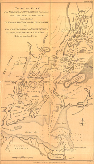
Chart of the Harbour of New York & the Counties Adjacent, from Sandy Hook to Kingsbridge, Comprehending thw Whole of New York and Staten Island and Part of Long Island & the Jersey Shore and Shewing the Defences of New York both by Land and Sea.
sold
- Digital Map Information
- Suitable for large format printing
- File Size: 7.11 MB
- File Type: ZIP / TIFF
- ICC color profile embedded
- Delivered instantly via download link
The title of this fine work says it all: 'Chart of the Harbour of New York & the Counties Adjacent, from Sandy Hook to Kingsbridge, Comprehending the Whole of New York and Staten Island and Part of Long Island & the Jersey Shore and Shewing the Defences of New York ... (more details)
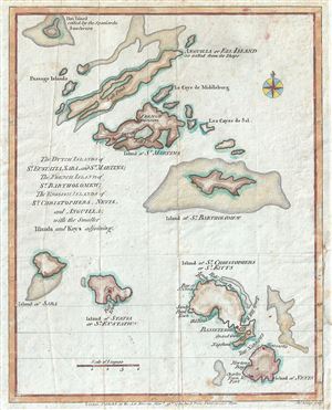
The Dutch Islands of St. Eustatia, Saba, and St. Martins; The French Island of St. Bartholomew; The English Islands of St. Christophers, Nevis, and Anguilla; with the smaller Islands and Keys adjoining.
sold
- Digital Map Information
- Suitable for large format printing
- Full resolution TIFF file
- ICC color profile embedded
- Delivered instantly via download link
This is a scarce 1781 John Lodge map of the Leeward Islands or the northern islands of the Lesser Antilles chain in West Indies. It covers from Hat Island (Sombrero) south as far as Nevis and depicts the colonial possessions of the Dutch, French and the English, ... (more details)
An attractive map of the Leeward Islands.
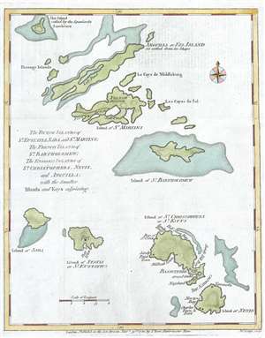
The Dutch Islands of St. Eustatia, Saba, and St. Martins; The French Island of St. Bartholomew; The English Islands of St. Christophers, Nevis, and Anguilla; with the smaller Islands and Keys adjoining.
sold
- Digital Map Information
- Suitable for large format printing
- DPI: 300
- File Size: 1.74 MB
- File Type: ZIP / TIFF
- ICC color profile embedded
- Delivered instantly via download link
This is a scarce 1781 John Lodge map of the Leeward Islands or the northern islands of the Lesser Antilles chain in West Indies. It covers from Hat Island (Sombrero) south as far as Nevis and depicts the colonial possessions of the Dutch, French and the English, ... (more details)
The last British redoubt its former colonies...
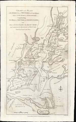
Chart and Plan of the Harbour of New York and the Couny Adjacent, from Sandy Hook to Kingsbridge, Comprehending The Whole ofNew York and Staten Islands, and Part of Long Isladn adn the Jersey Shore: And Shewing the Defences of New York Both by Land and Sea.
sold
- Digital Map Information
- Suitable for large format printing
- Full resolution TIFF file
- ICC color profile embedded
- Delivered instantly via download link
An important 1781 map of New York City near the end of the American Revolutionary War. This map was prepared by John Bew and engraved in London by John Lodge. Coverage extends from Sandy Hook to Fort Independence in the Bronx, and from Perth Amboy to western Long Island. When this map was issued, in November of 1781, news of the British defeat at the October 19, 1781 Battle of Yorktown, and the subsequent surrender of General Cornwallis, had already reached London. With its large, defensible harbor, multiple forts, and large defending force, it appeared that New York might soon be the last redoubt of British power in the rebelling colonies. This map reflects New York's defensive ability, citing the locations of new forts under construction, as well as existing forts repurposed for British defense, such as Fort Washington / Knyphausen. (more details)
One of the earliest obtainable views of the 1775 American Revolutionary War Battle of Bunker Hill.
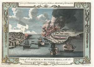
View of the Attack on Bunker's Hill, with the Burning of Charles Town, June 17, 1775.
sold
- Digital Map Information
- Suitable for large format printing
- Full resolution TIFF file
- ICC color profile embedded
- Delivered instantly via download link
One of the earliest obtainable views of the 1775 American Revolutionary War Battle of Bunker Hill. Published in 1783, this view illustrates the June 17, 1775 Battle of Bunker Hill, Boston, one of the first and most significant battles of the American Revolutionary War (1775 - 1783). The view looks east from Boston Harbor. Boston is on the left, Charlestown and Breed's Hill are afire on the right. British naval vessels fill the harbor, while long range cannons bombard Charlestown from Boston. The view is reasonably accurate, suggesting that the artist, 'Mr. Millar', probably George Henry Millar, may have witnessed the battle first hand or drew upon the experience of one who had. (more details)
A little known coast...

A Draught of the Windward Cost of the Mosquito Shore from Point Pattuck to St. Johns and Continued on the Spanish Main, to Escuda Veragua with the Islands, Keys, and Shoals, From the latest Authorities.
sold
- Digital Map Information
- Suitable for large format printing
- File Size: 5.89 MB
- File Type: ZIP / TIFF
- ICC color profile embedded
- Delivered instantly via download link
This is a scarce 1785 John Lodge map of the Mosquitia or Mosquito Coast, roughly corresponding to present-day eastern Nicaragua and Costa Rica. The map was issued to illustrate the heated colonial conflict between England and Spain over the remote and inhospitable coastline. (more details)