
Monin, Charles V. (sold)

Charles V. Monin (1830 - 1880) was a French map publisher working the early to mid 19th century. A progressive printer, Monin was one of the first cartographic printers in Europe to take advantage of the newly discovered lithographic engraving process. His workshops in Paris and Caen, France, produced three important atlases as well as numerous independent issue maps. Monin was a member of La Sociéte de Géographie in Paris. He is known to have worked with other French map publishers including Vuillemin and Fremin.
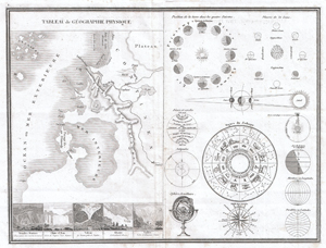
Tableau de Geographie Physique.
sold
- Digital Map Information
- Suitable for large format printing
- DPI: 300
- File Size: 15.06 MB
- File Type: ZIP / TIFF
- ICC color profile embedded
- Delivered instantly via download link
This is a very unusual 1838 map and astronomical chart by M. Monin. Divided into two sections. The left section is a Geographical Tableau, essentially a map of nothing, showing various geographical features and how they can be displayed. Shows mountains, plains, ... (more details)
Exceptional French comparative mountains and rivers chart after Bulla.
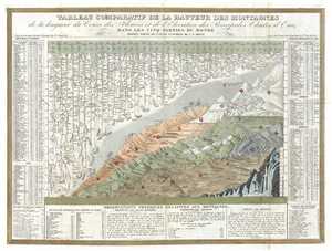
Tableau Comparatif de la Hauteur des Montagnes de la Longueur de Cours des Fleuves.
sold
- Digital Map Information
- Suitable for large format printing
- DPI: 300
- File Size: 14.24 MB
- File Type: ZIP / TIFF
- ICC color profile embedded
- Delivered instantly via download link
This is Charles V. Monin's 1838 comparative mountains and rivers chart. This extraordinary chart is considered the highest expression of the mountains and rivers convention as developed in the 19th century. It is a vast, detailed, comprehensive, and beautifully ... (more details)
Exceptional French comparative mountains and rivers chart after Bulla.
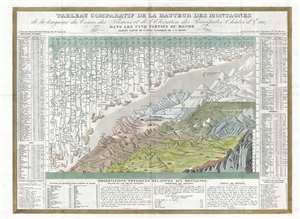
Tableau Comparatif de la Hauteur des Montagnes de la Longueur de Cours des Fleuves.
sold
- Digital Map Information
- Suitable for large format printing
- DPI: 300
- File Size: 13.32 MB
- File Type: ZIP / TIFF
- ICC color profile embedded
- Delivered instantly via download link
This is Charles V. Monin's 1838 comparative mountains and rivers chart. This extraordinary chart is considered the highest expression of the mountains and rivers convention as developed in the 19th century. It is a vast, detailed, comprehensive, and beautifully ... (more details)
Exceptional French comparative mountains and rivers chart after Bulla.
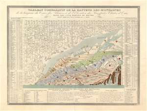
Tableau Comparatif de la Hauteur des Montagnes de la Longueur de Cours des Fleuves.
sold
- Digital Map Information
- Suitable for large format printing
- Full resolution TIFF file
- ICC color profile embedded
- Delivered instantly via download link
This is Charles V. Monin's 1838 comparative mountains and rivers chart. This extraordinary chart is considered the highest expression of the mountains and rivers convention as developed in the 19th century. It is a vast, detailed, comprehensive, and beautifully rendered tableau. Although roughly based upon Bulla's 1826 Tableau Comparatif, Monin added numerous topographical and geological notations, updated the older chart with regard to new information, redrew the waterfalls section, and incorporated textual data to either side of the chart proper. Even the ballooning feat of Gay-Lussac who attained an altitude of 7000 meters in 1808 is noted. (more details)
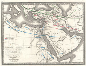
Geographie des Hebreux et Tableau de la Dispersion des Peuples Apres le Deluge
sold
- Digital Map Information
- Suitable for large format printing
- Full resolution TIFF file
- ICC color profile embedded
- Delivered instantly via download link
This is an 1839 C.V. Monin map of the Dispersal of the Hebrew Peoples After the Flood. This beautifully drawn map covers the lands occupied by the modern day countries of Turkey, Saudi Arabia, Egypt, Israel and Iraq. The travels the sons of Noah are indicated ... (more details)
Republic of Texas and the Oregon Question.
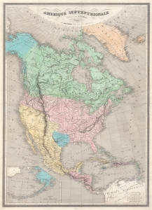
Amerique Septentrionale.
sold
- Digital Map Information
- Suitable for large format printing
- DPI: 600
- File Size: 74.99 MB
- File Type: ZIP / TIFF
- ICC color profile embedded
- Delivered instantly via download link
This is the 1845 Monin Map of North America highlighted the Republic of Texas and the Oregon Question. It highlights many of the most pressing political and international topics of the time: recognition of the Republic of Texas, the Oregon Question, and the westward expansion of the United States, all on the eve of the Mexican-American War (1846 - 1848). (more details)