
New England Street Railway Club (sold)

New England Street Railway Club (July, 1900 - c. 1925) was a technical and engineering organization based in Boston during the late 19th and early 20th centuries. The organization was founded by Robert H. Derrah (1865 - 1920) in July of 1900. Derrah subsequently worked as the club's secretary and published its bulletin. The club was a popular and politically potent organization at a time when rail and trolley transit was common throughout New England. They held annual dinners that attracted high society from throughout the region. President Taft is recorded as speaking at one such gathering. The society issued numerous tourist oriented publications related to rail travel in New England.
A first edition chromolithograph bird's-eye-view of New England electric and steam railroads at the turn of the century.
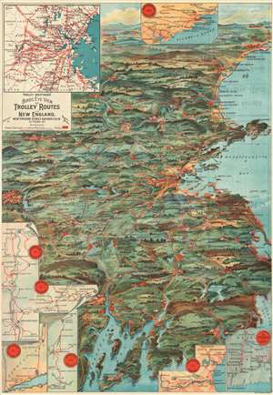
Trolley Wayfinder Birds Eye View of Trolley Routes in New England.
sold
- Digital Map Information
- Suitable for large format printing
- File Size: 22.77 MB
- File Type: ZIP / TIFF
- ICC color profile embedded
- Delivered instantly via download link
A radiantly rich chromolithograph first edition bird's-eye view style pocket map of New England issued in 1904 by John Jenness Lane and George Walker for the New England Street Railway Club. The view was produced upon Lane's election as secretary of the Club to promote the extensive but ephemeral New England streetcar network. Centered on Boston, New England's streetcar system is revealed extending north as far as Lewistown, Brunswick and Yarmouth, Maine; south to Narragansett Bay, Newport and New Bedford, Massachusetts; and west as far as Worcester. Both electric railroads and steam railroads are noted here, with red lines indicating an electric railroad and a black line marking the route of a steam railroad. Various parks, lighthouses, historic sites, and geographical features are also labeled. Popular routes are highlighted by inset maps and include: Springfield-Turners Falls, Worcester-Springfield, Springfield-New York City, Pittsfield and Vicinity, Rochester-Nashua, Portsmouth-Lewiston, and a triangle route from Worchester to Providence to New London and back. An inset of the vicinity of Boston is situated in the upper left. (more details)
A first edition chromolithograph bird's-eye-view of New England electric and steam railroads at the turn of the century.
Trolley Wayfinder Birds Eye View of Trolley Routes in New England.
sold
- Digital Map Information
- Suitable for large format printing
- Full resolution TIFF file
- ICC color profile embedded
- Delivered instantly via download link
A radiantly rich chromolithograph first edition bird's-eye view style pocket map of New England issued in 1904 by John Jenness Lane and George Walker for the New England Street Railway Club. The view was produced upon Lane's election as secretary of the Club to promote the extensive but ephemeral New England streetcar network. Centered on Boston, New England's streetcar system is revealed extending north as far as Lewistown, Brunswick and Yarmouth, Maine; south to Narragansett Bay, Newport and New Bedford, Massachusetts; and west as far as Worcester. Both electric railroads and steam railroads are noted here, with red lines indicating an electric railroad and a black line marking the route of a steam railroad. Various parks, lighthouses, historic sites, and geographical features are also labeled. Popular routes are highlighted by inset maps and include: Springfield-Turners Falls, Worcester-Springfield, Springfield-New York City, Pittsfield and Vicinity, Rochester-Nashua, Portsmouth-Lewiston, and a triangle route from Worchester to Providence to New London and back. An inset of the vicinity of Boston is situated in the upper left. (more details)
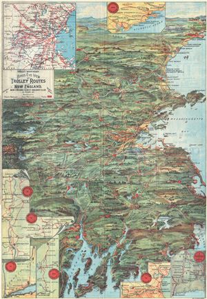
Trolley Wayfinder Birds Eye View of Trolley Routes in New England.
sold
- Digital Map Information
- Suitable for large format printing
- Full resolution TIFF file
- ICC color profile embedded
- Delivered instantly via download link
A scarce and stunning bird's eye view style pocket map of New England issued in 1905 by George Walker published by the New England Street Railway Club. The view reveals New England, centered on Boston, extending north as far as Lewistown, Brunswick and Yarmouth; south to Narragansett Bay, Newport and New Bedford; and west as far as Worcester. Train and trolley routes throughout the region are illustrated, with myriad towns and villages labeled throughout the region. Both electric railroads and steam railroads are noted here, with red lines indicating an electric railroad and a black line marking the route of a steam railroad. Various parks, lighthouses, historic sites, and geographical features are also labeled. Popular routes are highlighted by inset maps, which include: Springfield-Turners Falls, Worcester-Springfield, Springfield-New York City, Pittsfield and Vicinity, Rochester-Nashua, Portsmouth-Lewiston, and a triangle route from Worchester to Providence to New London and back. An inset of the vicinity of Boston is situated in the upper left corner. (more details)
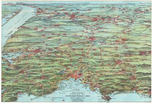
Trolley Pathfinder Birds Eye Map of Interurban Trolley Lines in New England.
sold
- Digital Map Information
- Suitable for large format printing
- Full resolution TIFF file
- ICC color profile embedded
- Delivered instantly via download link
This is a fascinating 1905 bird's eye view style pocket map of New England by George Walker issued by the Metropolitan News Company. Centered on Boston and oriented with north to the right, the map reveals New England from Portsmouth to New York City and Long ... (more details)
A bird's-eye-view of electric and steam railroads in turn of the century New England.
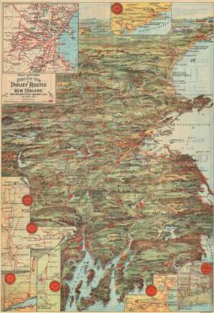
Trolley Wayfinder Birds Eye View of Trolley Routes in New England.
sold
- Digital Map Information
- Suitable for large format printing
- File Size: 31.41 MB
- File Type: ZIP / TIFF
- ICC color profile embedded
- Delivered instantly via download link
A scarce and stunning bird's eye view style pocket map of New England issued in 1905 by George Walker published by the New England Street Railway Club. The view reveals New England, centered on Boston, extending north as far as Lewistown, Brunswick and Yarmouth; south to Narragansett Bay, Newport and New Bedford; and west as far as Worcester. Train and trolley routes throughout the region are illustrated, with myriad towns and villages labeled throughout the region. Both electric railroads and steam railroads are noted here, with red lines indicating an electric railroad and a black line marking the route of a steam railroad. Various parks, lighthouses, historic sites, and geographical features are also labeled. Popular routes are highlighted by inset maps, which include: Springfield-Turners Falls, Worcester-Springfield, Springfield-New York City, Pittsfield and Vicinity, Rochester-Nashua, Portsmouth-Lewiston, and a triangle route from Worchester to Providence to New London and back. An inset of the vicinity of Boston is situated in the upper left corner. (more details)
New England's ephemeral trolley network.
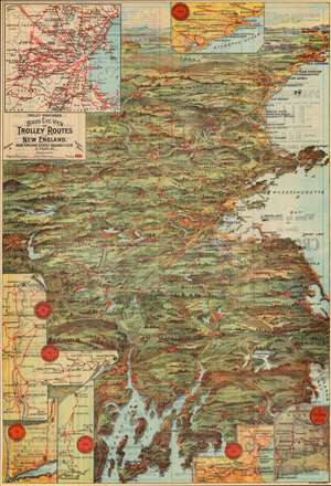
Trolley Wayfinder Birds Eye View of Trolley Routes in New England.
sold
- Digital Map Information
- Suitable for large format printing
- Full resolution TIFF file
- ICC color profile embedded
- Delivered instantly via download link
A radiantly rich chromolithograph bird's-eye view style pocket map of New England issued in 1905 by John Jenness Lane and George Walker for the New England Street Railway Club. The view was produced upon Lane's election as secretary of the Club to promote the extensive but ephemeral New England streetcar network. (more details)
Beautiful full color view illustrating Trolley Routes throughout New England.
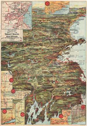
Trolley Wayfinder Birds Eye View of Trolley Routes in New England.
sold
- Digital Map Information
- Suitable for large format printing
- File Size: 10.06 MB
- File Type: ZIP / TIFF
- ICC color profile embedded
- Delivered instantly via download link
This is a fascinating 1907 bird's-eye view style Trolley Wayfinder pocket map of New England prepared by George Walker and issued by the New England Street Railway Club. This is most likely GeorgeH Walker's most beautiful map and certainly the most attractive ... (more details)

Trolley Wayfinder Birds Eye View of Trolly Routes in New England.
sold
- Digital Map Information
- Suitable for large format printing
- File Size: 14.12 MB
- File Type: ZIP / TIFF
- ICC color profile embedded
- Delivered instantly via download link
A scarce and stunning bird's eye view style pocket map of New England issued in 1908 by the New England Street Railway Club. Reveals New England centered around Boston. Extends north as far as Lewistown, Brunswick and Yarmouth; south to Narraganset Bay, ... (more details)