
Noguera, Clemente (sold)

Clemente Noguera (fl. c. 1809 – 1860) was a Spanish draftsman, naval pilot, and engraver based in Madrid during the middle part of the 19th century. Little is known of Noguera, but he was active as an engraver as early as 1809, when he engraved a plan of Zaragoza, Spain. He was a second lieutenant of the Spanish Navy in 1830. By, 1850, Noguera was a senior draftsman for the Direccion de Hidrografia. Clemente Noguera should not be confused with Juan Noguera, who was also a senior line-engraver at the Direccion de Hidrografia. The two engravers may or may not be related. Clemente was significantly older than Juan, and may have been an older relative.
First edition of a foundational chart.
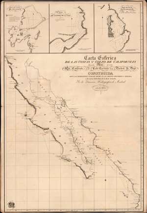
Carta Esferica de las Costas y Golfo de Californias llamado Mar de Cortes Que Comprende desde el Cabo Corrientes hasta el Puerto de S. Diego.
sold
- Digital Map Information
- Suitable for large format printing
- File Size: 26.15 MB
- File Type: ZIP / TIFF
- ICC color profile embedded
- Delivered instantly via download link
A spectacular 1825 1st edition of the Felipe Cardano y Bauzá / Dirección Hidrográfico foundational nautical chart or maritime map of Baja California and the Gulf of California. This important chart is the basis for much of the subsequent mapping of this region and is reflected in subsequent French and English charts. Coverage extends along the west coast of Mexico from San Diego, California, to Cabo Corrientes, Jalisco, Mexico, including all of modern-day Baja, the Gulf of California, and the Sonora and Sinaloa coasts. (more details)
The Cadiz-Havana Route.
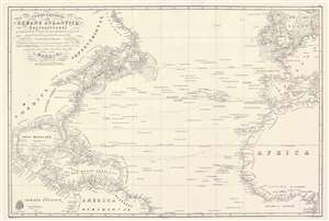
Carta General del Oceano Atlantico Septentrional que comprende desde el Ecuador hasta 55° 35' de latitud norte, y entre la longitud de 93° 45' al Oeste, y 17° al Este del meridiano de Cadiz.
sold
- Digital Map Information
- Suitable for large format printing
- Full resolution TIFF file
- ICC color profile embedded
- Delivered instantly via download link
This is a rare 1837 / c. 1851 Direccion Hidrografía nautical chart or maritime map of the Atlantic Ocean with manuscript notations relating to an 1864 voyage from Cadiz to Havana. Coverage extends from Labrador and the North Sea to the Equator, and from the Gulf of Mexico to the Mediterranean. The chart offers meticulous coastal detail throughout, as well as interesting annotations regarding sighting of rocks, banks, and reefs sighted along the central route between Europe and America. Such charts were used for broad voyage planning and open sea, smaller more detailed charts were then used for approaches to land. (more details)
Rare early map of Florida based upon Spanish navigation.
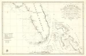
Carta de los Canales de Bahama, Providencia y Santaren, Costas de la Florida e Isla de Cuba con los cayos y bajos, las islas y sondas adyacentes a esta
sold
- Digital Map Information
- Suitable for large format printing
- DPI: 600
- File Size: 36.24 MB
- File Type: ZIP / TIFF
- ICC color profile embedded
- Delivered instantly via download link
A stunningly engraved 1838 Spanish nautical chart of Florida and the Bahamas (Lucayas) used by the Dirección Hidrografía. Coverage extends from roughly from St. Augustine to Cuba, and from the Bay of St. Andres (Saint Andrew Bay) to Rum Cay and I. Conception. There is very little inland detail, but the Florida Keys, Tampa bay, and the Vicinity of Miami are well maps - with notes as to where fresh water can be found. The routes of several seven voyages are noted here, and were influential in preparing the map, most undertaken between 1794 and 1820. The general shape of Florida of Florida is consistent with maps of the period, including an exaggerated hook south of Cape Romano, and an unexplored region in the vicinity of the Crystal River south of the Cedar Keys. (more details)
Early days Florida as part of the U.S.
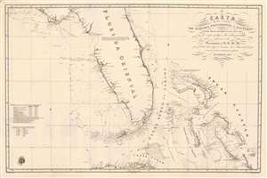
Carta de los Canales de Bahama, Providencia y Santaren, Costas de la Florida e Isla de Cuba con los cayos y bajos, las islas y sondas adyacentes a esta...
sold
- Digital Map Information
- Suitable for large format printing
- Full resolution TIFF file
- ICC color profile embedded
- Delivered instantly via download link
A strikingly engraved 1838 Spanish nautical chart of Florida and the Bahamas (Lucayas) published in Madrid by the Spanish Dirección Hidrografía. Coverage extends roughly from St. Augustine to Cuba, and from the Bay of St. Andres (Saint Andrew Bay) to Rum Cay and I. Conception. There is very little inland detail, but the Florida Keys, Tampa Bay, and Biscayne Bay are well mapped - with notes identifying water sources. The routes of several voyages influential in preparing the map are noted, for the most part, undertaken between 1794 and 1820. The Cape Florida lighthouse near Miami, constructed in 1825, is also noted. The general shape of Florida is consistent with maps of the period, including an exaggerated hook south of Cape Romano, and an unexplored region in the vicinity of the Crystal River south of the Cedar Keys. Pencil marks track the map's use on a single voyage, from Cadiz (Spain) to Havana. (more details)
Rare set of Spanish nautical charts.
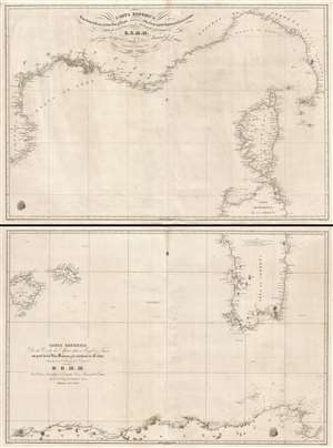
Carta esférica de las costas de Francia, Cerdeña, Luca y Toscana con las yslas de Elba, Córcega y parte septentrional de la de Cerdeña. / Carta Esférica de la Costa de Africa entre Argel y Tunez con parte de las Yslas Baleares y la meridional de Cerdeña.
sold
- Digital Map Information
- Suitable for large format printing
- DPI: 300
- File Size: 33.51 MB
- File Type: ZIP / TIFF
- ICC color profile embedded
- Delivered instantly via download link
This is a rare 1838 two-part Spanish nautical chart of the western Mediterranean in the vicinity of Corsica, Sardinia, and the Balearic Islands. The map covers from Majorca (Mallorca) and Menorca (Minorca) east to Sardinia and Corsica and from the French Rivera ... (more details)