
Radefeld, Carl Christian Franz (sold)

Carl Christian Franz Radefeld (1788 - 1874) was a German lawyer and cartographer. Radefeld was born in Jena, Germany, where he studied law and theology and began working as a lawyer in 1811. He became interested in cartography in the 1840s when he became involved with map and atlas publisher Joseph Meyer (1796 - 1856). From 1846, he contributed maps to Meyer's Groẞer Hand-Atlas (1843 - 1860).
Independent Republic of Texas - and other disputes.
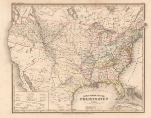
Nord-Americanische Freistaaten.
sold
- Digital Map Information
- Suitable for large format printing
- File Size: 11.33 MB
- File Type: ZIP / TIFF
- ICC color profile embedded
- Delivered instantly via download link
This is an 1845 Joseph Meyer and Carl Radefeld map of the United States and a pre-annexation Republic of Texas leading up to the Mexican-American War (1846 - 1848). The map additionally highlights border disputes between the United States and British Canada - the '54-40 or Fight' dispute and the Aroostook War. An index in the lower left identifies the Slave States, thus underscoring rising tensions between North and South. The map is also interesting for the term 'Fristaaten', a German word meaning 'Free States', not a common name for the United States, but one deep with meaning in Germany. 'Fristaaten' typically referred to German states, like Bavaria and Saxony, which were republics independent of monarchial rule. In the lead-up to the Revolutions of 1848, this term would have had great meaning for Meyer's German audience, setting up the United States as a republican ideal. (more details)
On the eve of the Mexican-American War.
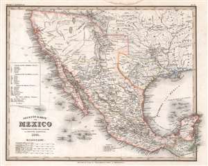
Neueste Karte von Mexico.
sold
- Digital Map Information
- Suitable for large format printing
- Full resolution TIFF file
- ICC color profile embedded
- Delivered instantly via download link
This is an 1845 Carl Radefeld map of Mexico and the Republic of Texas. Published on the eve of the Mexican-American War (1846 - 1848), Mexico stretches from Oregon to Guatemala, the border of the 1819 Adams-Onís Treaty. The Republic of Texas appears in one of its smallest border configurations, suggesting that the German cartographers were sympathetic to Mexico's arguments about Texas's rightful borders and not the more expansive borders advocated by Texans. Rivers are labeled throughout, including the Colorado, Nueces, and Rio Grande. Two mythical rivers, the Buenaventura and Francisco, are also identified, and two great salt lakes illustrated. San Antonio, Santa Fe, Albuquerque, Mexico City, and Veracruz are named, along with numerous other cities and towns. Mexican states are labeled using Roman numerals corresponding with an index along the left border. (more details)
The aftermath of the Opium War.
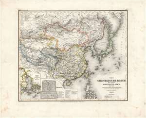
Chinesische Reich mit seinen Schutzstaaten nebst dem Japanischen Inselreiche.
sold
- Digital Map Information
- Suitable for large format printing
- DPI: 600
- File Size: 34.31 MB
- File Type: ZIP / TIFF
- ICC color profile embedded
- Delivered instantly via download link
Here is Carl Radefeld's attractive 1846 map of East Asia, produced for Meyer's Grosser Hand-Atlas. It depicts the region in the wake of the Opium War (1839-1842), when the momentous changes initiated by that conflict had just begun and were not yet fully understood. (more details)
The origins of the Great Game.
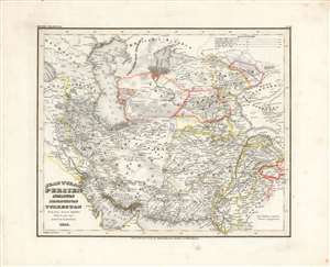
Jran, Turan, Persien, Afghanistan, Beludschistan, Turkestan.
sold
- Digital Map Information
- Suitable for large format printing
- DPI: 600
- File Size: 31.34 MB
- File Type: ZIP / TIFF
- ICC color profile embedded
- Delivered instantly via download link
This is Carl Radefeld's appealingly hand-colored 1846 map of the Middle East and Central Asia, produced for Meyer's Grosser Hand-Atlas. It depicts the region as both British and Russian influence were increasing, setting off the 'Great Game' competition between the two empires. (more details)
Last days of the Republic of Texas. Unique configuration!
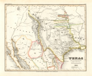
Texas nach den besten Quellen entw. u. gez. vom Hauptm. Radefeld.
sold
- Digital Map Information
- Suitable for large format printing
- File Size: 8.87 MB
- File Type: ZIP / TIFF
- ICC color profile embedded
- Delivered instantly via download link
An important 1846 first edition of Joseph Meyer and Carl Christian Franz Radefeld's map of the Republic of Texas in its final days, just before joining the United States. This map was issued shortly before the outbreak of the Mexican-American War (1846 - 1848) and, as such, constitutes the fullest expression of independent Texas, including a unique configuration incorporating New Orleans. Texas was of great interest to Meyer's primarily German audience, to whom immigration was actively promoted through a number of Texas-booster societies, some of which were legitimate and others which were outright cons. (more details)
Geognostic study of the United States shortly after the Gold Rush.
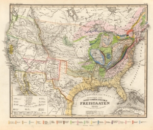
Geognostische Karte der Nord-Americanischen Freistaaten.
sold
- Digital Map Information
- Suitable for large format printing
- File Size: 13.19 MB
- File Type: ZIP / TIFF
- ICC color profile embedded
- Delivered instantly via download link
A superb 1853 Carl Radefeld and Joseph Meyer geologic map of the United States with special highlighting of the California Gold Region. (more details)