
Service géographique de l'armée (sold)

Service Géographique de l'Armée (1887 - Present) was created from the French Dépot de la Guerre in 1887 and was charged with undertaking all the geodesic, topographic, and cartographic needs of the French army during times of peace and war. The Service was divided into five sections: Geodesy, the Levés de précision, topography, cartography, and accounting. The accounting section dealt with the logistical side of running the Service géographique, including the distribution and shipping of its products.
Tensions between Greeks and Turks in Anatolia.
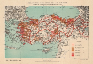
Repartition des Grecs en Asie-Mineure d'apres les statistiques consulaires grecques (1912).
sold
- Digital Map Information
- Suitable for large format printing
- File Size: 282.54 MB
- File Type: ZIP / TIFF
- ICC color profile embedded
- Delivered instantly via download link
This is a 1919 Service Géographique de l'Armée map of Turkey illustrating Greek populations throughout Anatolia. This piece visualizes Greek influence on the Turkish state in the wake of World War I (1914 - 1918). (more details)
Last Days of French Rule in Lebanon.
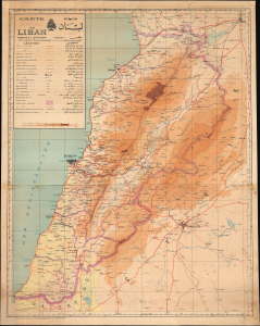
Carte générale du Liban / خريطة لبنان عامة.
sold
- Digital Map Information
- Suitable for large format printing
- File Size: 66.56 MB
- File Type: ZIP / TIFF
- ICC color profile embedded
- Delivered instantly via download link
This is a 1945 bilingual French-Arabic wall map of Lebanon, prepared by the Service Géographique des Forces Françaises Libres (Geographic Service of Free France). The map captures the final days of the French Mandate World in Lebanon at the end of World War II (1939 - 1945). (more details)