
Thayer, Benjamin W. (sold)

Benjamin W. Thayer (1814 - December 17, 1875) was a Boston based lithographer, newspaper investor, and real-estate broker active in the middle part of the 19th century. Thayer published as 'B. W. Thayer and Company.' He appears to have had two periods of activity, between 1840 and 1847 and between 1851 and 1853. In 1840 he took over the shop of William S. Pendleton and Moore, which he rand with his brother-in-law, John H. Bufford, and John E. Moody. He abandoned the partnership in 1846, establishing himself at 208 Washington Street as a 'fancy goods seller' and lithographer. He does not appear in the Boston Directory between 1848 and 1850, suggesting he was no longer active. He reestablished his partnership with Bufford in 1851 and appears again in the Directory until 1853, when he sold the shop to S. W. Chandler. He leveraged the assets of the sale to become a wealthy newspaper investor and real estate agent.
The Apocalypse in 1843?
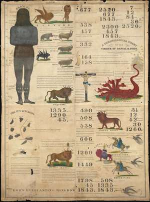
A Chronological Chart of the Visions of Daniel and John.
sold
- Digital Map Information
- Suitable for large format printing
- Full resolution TIFF file
- ICC color profile embedded
- Delivered instantly via download link
Known as the '1843 Chart', this rare Millerite chronological chart predicts the end-of-days in 1843. Printed on cloth by Benjamin Thayer, this chart is a didactic tool illustrating the predictions of William Miller. The chronology records world history from roughly 700 BC to 1843, when Miller, based upon Biblical calculus and prophetic interpretation, predicted Christ would come again heralding Armageddon. The allegorical 'beasts' of Armageddon are illustrated, among them various goats, a 7 headed dragon, a lion-bull creature, and more. The chart was published by Joshua Vaughan Himes, who served as Miller's publicist and pamphleteer after 1840. he publicaion of htis chart was significant as it was meant both to fulfill prophecy and for use at 'big tent' evangelical gatherings. (more details)
First published map of Jaffrey, New Hampshire.
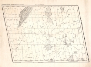
Map of Jaffrey N.H. by J. D. Gibbs, March 1850.
sold
- Digital Map Information
- Suitable for large format printing
- DPI: 600
- File Size: 31.48 MB
- File Type: ZIP / TIFF
- ICC color profile embedded
- Delivered instantly via download link
This is the 1850 Jonathan Danforth Gibbs large-scale map of Jaffrey, New Hampshire, considered the first separately issued map of that region. Mount Monadnock, one of the highest points in southern New Hampshire and at the time the stomping ground of the transcendentalists, appears prominently yet idiosyncratically illustrated in the upper left. (more details)