
Worley, George (sold)

George Worley (c. 1819 - November 21, 1879) was an English lithographer active in Philadelphia. Born in England, Worley lived in Philadelphia by 1843 where he worked as an artist. He worked as a lithographer for Robert Pearsall Smith in his map publishing establishment from c. 1856 - 1859. In 1858 or 1859, Worley became a partner in the firm Worley, Bracher, and Matthias with William Bracher (1827 - 1912) and Benjamin Matthias. Worley, Bratcher, and Matthias lasted until 1860 when Matthais left. After Matthias's departure, Worley and Bracher renamed the firm Worley and Bracher and remained in operation until 1879, during which time they produced over 200 maps and atlases. Worley married Ann Thakeray on March 14, 1841 and died of liver disease.
Monumental map of Boston.
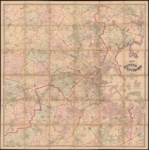
Map of the City of Boston and its Environs.
sold
- Digital Map Information
- Suitable for large format printing
- Full resolution TIFF file
- ICC color profile embedded
- Delivered instantly via download link
This is an 1867 Henry Francis Walling and Ormando W. Gray map of Boston, Massachusetts, and environs. Boston appears to the right of center, with East Boston and South Boston both labeled. Boston Common and the Public Garden are labeled in Boston, along with streets, wharves, railroad lines, and a handful of buildings. Outside Boston, the map depicts from Wilmington, Danvers, and North Beverly south to West Medway and Walpole Centre and from Ashland Center east to Marblehead, Salem, and Beverly. Hundreds (if not thousands) of private residences are identified by the owner's name throughout, along with banks, schools, railroad stations, churches, and cemeteries. Roads, railroads, hills, lakes, rivers, and other physical features are noted. (more details)
A rare city plan of Farmington, Maine.
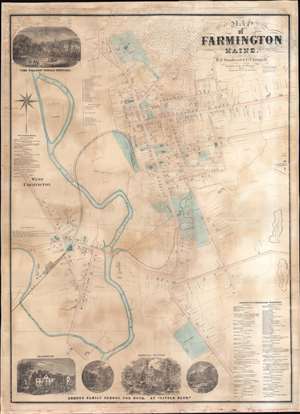
Map of Farmington Maine.
sold
- Digital Map Information
- Suitable for large format printing
- Full resolution TIFF file
- ICC color profile embedded
- Delivered instantly via download link
This is an 1874 E.F. Sanford and C.T. Leggett city plan or map of Farmington, Maine. Created by soliciting subscriptions from the town's businesspeople and residents, the map depicts from the Willows Female Seminary to S. Norton's house south of the cemetery on Main Street and from the railroad shops in West Farmington to the slate quarries east of town. Houses throughout town are illustrated and identified by the owner's name and the lots are delineated. Schools (including the State Normal School), churches, and offices are labeled throughout town as well. Other illustrated locations around town include the railroad depot (serviced by the Androscoggin Division of the Maine Central Railroad), the sweet corn factory, the brick yard, the cattle yards, S.R. Leland's Apple Orchard, and the H.R. Butterfield shovel handle factory. References for thirty-five numerically identified locations along Main Street and Broadway in Farmington occupy a space in the upper left quadrant. A directory for West Farmington appears along the left border. A view of the Willows Female Seminary occupies the upper left corner. A series of four views along the bottom border highlight different scenes associated with the Abbott Family School for Boys. (more details)