
Neele, Josiah (sold)

Josiah Neele (March 30, 1804 - March 22, 1876) was a British map engraver, printer, and publisher active in London during the middle part of the 19th century. Neele was the son of Samuel John Neele (1758 - 1824), also a prominent map engraver. He apprenticed under his father along with Ebenezer Stalker (1780 - 1847) with whom he briefly partnered until 1825. At that time, he went into business with his uncle, George Neele, and his brother, James Neele. George retired in 1826, ending that partnership, after which the brothers published until 1829 under the imprint of 'James and Josiah Neele'. Josiah subsequently continued the business under his own name, operating from their former offices at 352 Strand, until 1836, when he declared bankruptcy. In 1845 he married Eliza Atwood of Haverfordwest and in the wedding documents he is described as a stationer. He retired to Wiltshire in 1871 and died five years later in 1876.
The best 19th century map of London.
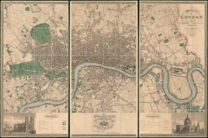
Map of London, from An Actual Survey made in the Years 1824, 1824 and 1826 by C. an J. Greenwood.
sold
- Digital Map Information
- Suitable for large format printing
- Full resolution TIFF file
- ICC color profile embedded
- Delivered instantly via download link
This is the rare first edition of Christopher and John Greenwood's large-scale 1827 map of London, here in a spectacularly preserved example. It is considered the largest and finest plan of London to appear in the 19th century. The present example is presented in three linen-backed folding sections, and is accompanied by its original leather slipcase. (more details)
Best 19th century map of London.
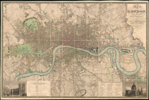
Map of London, from An Actual Survey made in the Years 1824, 1824 and 1826 by C. and J. Greenwood.
sold
- Digital Map Information
- Suitable for large format printing
- File Size: 284.14 MB
- File Type: ZIP / TIFF
- ICC color profile embedded
- Delivered instantly via download link
This is the rare 1830 second edition of Christopher and John Greenwood's large-scale map of London, here in a spectacularly preserved example. It is considered the largest and finest plan of London to appear in the 19th century. The present example is linen-backed and accompanied by its original green leather slipcase. (more details)
One of the most beautiful maps of the Holy Land from the 19th century.
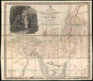
Seaton's Map of Palestine, or the Holy Land, with part of Egypt.
sold
- Digital Map Information
- Suitable for large format printing
- DPI: 600
- File Size: 67.38 MB
- File Type: ZIP / TIFF
- ICC color profile embedded
- Delivered instantly via download link
This is a first edition example of Robert Seaton's 1835 map of Palestine or the Holy Land. It is one of the most decorative maps of the Israel / Palestine / Syria region to appear in the 19th century. (more details)