
Sahab, Abbas (sold)

Abbas Sahab (1921 – April 2, 2000) was an Iranian cartographer and publisher active in Terhan in middle part of the 20th century. He is considered the 'Father of Iranian Cartography.' Sahab was born in Fam, Tafresh district, Iran. He was the son of Ostad Abolghasem Sahab Tafreshi, an Iranian writer, publisher and, from 1935, founder of the Sahab Drafting and Geographic Institute.This was the first private geographical publisher in modern Iran. The company was soon passed to Abbas, under whose guidance the company published over 1500 works, including maps, atlases, prints, and scientific and medical illustrations. Abbas himself traveled throughout Iran, often mapping individual towns and adding his own artistic flair to the maps. His most important maps illustrate Tehran, Esfahan, and Mazandaran. He also traveled extensively abroad, producing maps of Afghanistan, Pakistan, Iraq, and Turkey. After his death, the Sahab Drafting and Geographic Institute was taken over by his sons and remains an active concern to this day.
Features several smaller pictorial maps of Iran's mineral wealth, historical sites, and traditional tribal costumes.
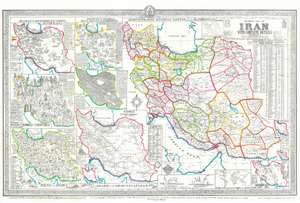
General Map of Iran with Complete Details.
sold
- Digital Map Information
- Suitable for large format printing
- File Size: 60.44 MB
- File Type: ZIP / TIFF
- ICC color profile embedded
- Delivered instantly via download link
This is a 1957 Abbas Sahab map of Iran. The map depicts Iran in full, from Iraq and Turkey to Afghanistan and Pakistan and from the Caucasus, the Caspian Sea, and Turkmenistan to the Persian Gulf and the Gulf of Oman. Using inset maps of varying size, Sahab illustrates political, cultural, historical, and economic aspects of Iran. A large political map highlighting the ostans, provinces, shahrestans, and townships within the country occupies the right half of the sheet. Each ostan is bordered in a different color, and further subdivided into provinces and other administrative districts. Many cities, towns, and villages are labeled, including Tehran, Isfahan, and Shiraz.
On the left side of the sheet, seven smaller maps of varying size illustrate different aspects of Iranian society and culture. Starting at the top left, a pictorial map traces Iranian industry and factory production using different symbols for each industry/factory/handicraft. Chemical factories, canneries, cotton gins, oil industry facilities, and other factories producing cigarettes, sugar, leather are highlighted here, as well as carpet making, perfumeries, and artists. To the right of the industrial map is a pictorial map of Iran's historical monuments and other interesting sites. Fifty-two different sites are numerically identified, illustrated in profile, and identified in the textboxes along the left and right sides. Perhaps a bit incongruously, people, presumably tourists on holiday, are illustrated in bathing suits in the Caspian Sea. Below these two maps sits a pictorial map of traditional Iranian tribal costumes that illustrates the costumes of sixty-five different tribes. Next to this map is a topographical relief map that illustrates Iran's topography, naming fifty-eight mountain peaks. Below these two maps, along the bottom border, a pictorial map depicts Iranian flora and fauna. On left side, a sub-map defines the Iranian rail network. A very small inset map in the lower left corner illustrates Iran's air routes.
Along the bottom, two different graphs depict the elevation of the Iranian plateau above sea level, providing the viewer with a better understanding of just how high most of the country sits. Another small inset map of the world is included along the bottom border and is meant to show where Iran is in relation to the rest of the world. Yet another inset map, in the lower right corner, traces the mineral wealth of Iran identifying deposits of aluminum, gold, iron, oil, salt, marble, and copper, among others. Two small inset maps situated along the right side provide general information about Iran and its forested region. The general information provided includes the area, which is 622,000 square miles, its population (18,000,000), and the number of villages (50,000). An alphabetical index of cities and towns with the altitudes and distances from Tehran is included in the upper right corner. The whole is surrounded by a pictorial border. (more details)
On the left side of the sheet, seven smaller maps of varying size illustrate different aspects of Iranian society and culture. Starting at the top left, a pictorial map traces Iranian industry and factory production using different symbols for each industry/factory/handicraft. Chemical factories, canneries, cotton gins, oil industry facilities, and other factories producing cigarettes, sugar, leather are highlighted here, as well as carpet making, perfumeries, and artists. To the right of the industrial map is a pictorial map of Iran's historical monuments and other interesting sites. Fifty-two different sites are numerically identified, illustrated in profile, and identified in the textboxes along the left and right sides. Perhaps a bit incongruously, people, presumably tourists on holiday, are illustrated in bathing suits in the Caspian Sea. Below these two maps sits a pictorial map of traditional Iranian tribal costumes that illustrates the costumes of sixty-five different tribes. Next to this map is a topographical relief map that illustrates Iran's topography, naming fifty-eight mountain peaks. Below these two maps, along the bottom border, a pictorial map depicts Iranian flora and fauna. On left side, a sub-map defines the Iranian rail network. A very small inset map in the lower left corner illustrates Iran's air routes.
Along the bottom, two different graphs depict the elevation of the Iranian plateau above sea level, providing the viewer with a better understanding of just how high most of the country sits. Another small inset map of the world is included along the bottom border and is meant to show where Iran is in relation to the rest of the world. Yet another inset map, in the lower right corner, traces the mineral wealth of Iran identifying deposits of aluminum, gold, iron, oil, salt, marble, and copper, among others. Two small inset maps situated along the right side provide general information about Iran and its forested region. The general information provided includes the area, which is 622,000 square miles, its population (18,000,000), and the number of villages (50,000). An alphabetical index of cities and towns with the altitudes and distances from Tehran is included in the upper right corner. The whole is surrounded by a pictorial border. (more details)
Rare Farsi edition of Sahab's map!
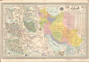
This is a 1957 Abbas Sahab map of Iran, in the rare Farsi (Persian) edition. The map depicts Iran in full, from Iraq and Turkey to Afghanistan and Pakistan and from the Caucasus, the Caspian Sea, and Turkmenistan to the Persian Gulf and the Gulf of Oman. Issued under the Shah, long before the Iranian Revolution, this map represents a golden age for Iran, when liberal reforms were going into effect, and Iran itself was an attractivce destination for both tourists and business. Using inset maps of varying size, Sahab illustrates political, cultural, historical, and economic aspects of Iran. A large political map highlighting the ostans, provinces, shahrestans, and townships within the country occupies the right half of the sheet. Each ostan is shaded a different color, and further subdivided into provinces and other administrative districts. Many cities, towns, and villages are labeled, including Tehran, Isfahan, and Shiraz. (more details)
Rare map of Tehran by the Father of Modern Iranian Cartography.
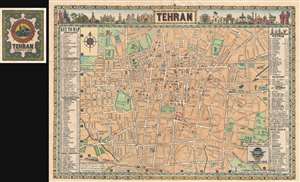
Tehran.
sold
- Digital Map Information
- Suitable for large format printing
- File Size: 18.52 MB
- File Type: ZIP / TIFF
- ICC color profile embedded
- Delivered instantly via download link
This is a rare pictorial map of Tehran issued in 1958 by Abbas Sahab, considered the 'Father of Iranian Cartography.' Based upon Addass's own pen and ink drawing, this map covers central Tehran centered on Parke E Shahr. It extends west roughly as far as Jeyhoon ... (more details)
Rare Tehran imprint.
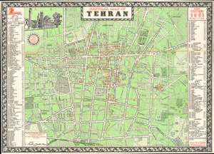
Central Map of Tehran.
sold
- Digital Map Information
- Suitable for large format printing
- Full resolution TIFF file
- ICC color profile embedded
- Delivered instantly via download link
This is a 1961 Abbas Sahab city plan or map of central Tehran, Iran. Composed almost entirely in English, streets throughout the area are labeled using Latin characters. A handful of locations around the city are identified on the map as well, including the Sahab Geographical and Drafting Institute, Air Force Headquarters, the Doshan-Tappeh Airport, Pahlavi Hospital, and the U.S. and Soviet Embassies. Red numbers incised in red circles mark 218 other locations, including book shops, travel agencies, hotels, museums, banks, government ministries and departments, and embassies. These correspond with indexes along the left and right borders. (more details)
A city map of Tehran during the reign of the Shah.
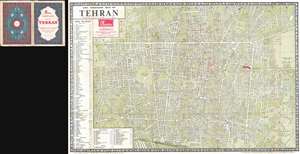
The Complete Map of Tehran.
sold
- Digital Map Information
- Suitable for large format printing
- File Size: 22.7 MB
- File Type: ZIP / TIFF
- ICC color profile embedded
- Delivered instantly via download link
This is a 1963 Abbas Sahab bilingual city map or plan of Tehran. The map depicts the city from Kh. Karoun to the Lands of Doulab and Doshan Tapeh Airport and from Kh. Chehel Metri to Kh. Shoosh and the Tehran Railway Station. Highly detailed, myriad streets are ... (more details)