
Stöcklein, Joseph [Stoecklein] (sold)

Joseph Stöcklein [Stoecklein] (July 30, 1676 – December 28, 1733) was a Jesuit priest, missionary, and scholar active in the late 17th and early 18th centuries. He was born in Oettingen, Germany and joined the Jesuit order in Vienna around 1700. He served as a priest in military encampments where he became popular as a preacher. Afterwards he became the head of the Jesuit library in Graz, Switzerland, a position he maintained for six years. During this tenure he began work on his opus, the Welt-Bott, a vast compilation of Jesuit missionary letters and narratives translated into vernacular German intended both to glorify the priesthood and share valuable information about the world. Today this work is exceedingly rare.
Mash-up of indigenous and European cartography.
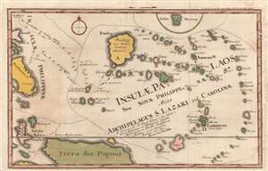
Insulae Palaos seu Novae Philippinae 87, alias Archipelagus S. Lazari vel Carolinae.
sold
- Digital Map Information
- Suitable for large format printing
- DPI: 600
- File Size: 14.58 MB
- File Type: ZIP / TIFF
- ICC color profile embedded
- Delivered instantly via download link
A beautifully hand-colored 1726 Stöcklein map of Palau and surrounding islands in the southwestern Pacific. This map is a fascinating mash-up of Europeand and Indigenous cartography. It is an especially early presentation of these islands, based on a cartographic game of telephone from native Palauans waylaid in the Philippines through the Jesuits and then to the European public via Joseph Stöcklein. (more details)
One of the earliest, if not the earliest, obtainable specific printed map of Taiwan or Formosa.
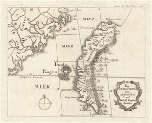
Die Insel Formosa neu abgemessen auf Befehl Kaysers Kamhi. [The Island of Formosa As Newly Surveyed By Order of Emperor Kamhi.]
sold
- Digital Map Information
- Suitable for large format printing
- Full resolution TIFF file
- ICC color profile embedded
- Delivered instantly via download link
This rare find is one of the earliest, if not the earliest, obtainable printed map of Taiwan or Formosa Island. It was issued around 1726 to illustrate Joseph Stöcklein's [Stoecklein] compellation of Jesuit missionary letters Allerhand So Lehr-als Geist-reiche ... (more details)
The Earliest Acquirable Printed Map of the Caroline Islands
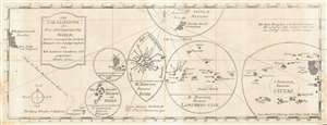
Die Carolinische oder Neu=Philippinische Inseln; Welche sonst auch das Seeland Palaos oder S. Lazari heissen von R. P. Antonio Cantova, e S. J. gezeichnet Anno 1722.
sold
- Digital Map Information
- Suitable for large format printing
- DPI: 600
- File Size: 5.58 MB
- File Type: ZIP / TIFF
- ICC color profile embedded
- Delivered instantly via download link
The earliest printed map of the Caroline Islands, produced by Joseph Stöcklein in 1728 for inclusion in Welt-Bott, his monumental collection of Jesuit missionary letters. The map was based on the reports of the Jesuit Juan Antonio Cantova (1686-1731), the first to establish a Christian mission in the Caroline Islands in 1722. The publication of this map pre-dates Cantova's 1731 establishment of his mission in Ulithi and subsequent death at the hands of the natives of the island Mogmog (among the island group marked III. Proving Names Egoi on the map.) Cantova's information, as reported in his 1722 letter to the confessor to the King of Spain, was derived from interviews with two separate groups of natives who were blown off course and shipwrecked at Guam, where Cantova was based. From these, Cantova learned their language and received the account of the islands which informs this map. The map's division of the archipelago into five distinct groups was derived from these interviews, as were the locations of safe anchorages was shown. The map also shows 1712 track of Bernard de Egui from the Philippines to the islands of S. Andrea, the first European contact with the Caroline Islands. (more details)
Earliest Acquirable Issue of D'Avila's Paraguay.
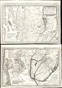
Ober-Paraguarien : Nebst denen Länderen Baures, Tschikiten, Schareyes, Paraguas, Toromonas, Moschos, Ytonamas etc. samt einem Theil dern Königreichen Tschili und Peru etc. etc/ Die Landschaft nider-Paraguaria : Samt den Ländern Tucuman, Tscharvas, Tschaco, Mocobis, und einem Theil des Königreichs Tschili ec.
sold
- Digital Map Information
- Suitable for large format printing
- Full resolution TIFF file
- ICC color profile embedded
- Delivered instantly via download link
This is Joseph Stöcklein's 1728 map of central South America illustrating the Jesuit province of Paraguay and the surrounding regions, including present-day Uruguay, parts of Argentina, and Brazil. This two-sheet map is one of the earliest iterations of the 1722 map produced by Juan Francisco D'Avila, the most complete map of the Rio de la Plata watershed available at the time. The earliest printed D'Avila map was engraved by Giovanni Petroschi and published in Rome in 1726. In his Cartografia Jesuttica del Rio de la Plata, scholar Guillermo Furlong Cardiff hailed this unacquirable map as 'without doubt the most complete and most comprehensive map undertaken by the Jesuits up to the middle of the eighteenth century.' (Buenos Aires, 1936, p. 44). The present map, engraved in 1728 and published in the 1729 installment of Stöcklein's collection of Jesuit Relations, is the earliest acquirable version of Dávila's work. (more details)