
Wanamaker, John (sold)
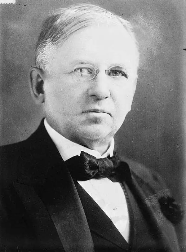
John Wanamaker (July 11, 1838 - December 12, 1922) was an American merchant and public figure, and a pioneer in advertising and marketing. Born in Philadelphia, Pennsylvania, he would found the famous department stores that carried his name. Later in life he served as U.S. Postmaster General during the term of President Benjamin Harrison, (1889 - 1893.) He opened his first, Philadelphia store - Oak Hall - in 1861; his second store opened in 1869, and this one would be named John Wanamaker and Co.; in 1875, he moved the growing business into an abandoned railroad depot and converted it into what is considered the first department store in Philadelphia. The 12-story Grand Depot, with its Grand Court, pipe organ, iconic Eagle statue, and holiday light shows became an institution. In 1896 Wanamaker expanded into New York City, taking over space that had been established by A. T Stewart. He expanded again into an adjacent, newly-built 14-story edifice which Wanamaker cannily had built with its 32 acres of retail space directly accessible via the new Astor Place subway station. A proponent of the power of advertising, he was the first retailer to place half and later full-page newspaper advertisements, eventually hiring the world's first full-time copywriter to fuel his circulars. The arrival of Wanamaker's stores in New York was spearheaded with a vigorous newspaper campaign, including the clever innovation of producing the first subway map intended for use by its ridership.
An Extremely Rare Early Subway Image.
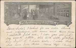
The Wanamaker Station in the Subway at Astor Place.
sold
- Digital Map Information
- Suitable for large format printing
- Full resolution TIFF file
- ICC color profile embedded
- Delivered instantly via download link
This 1904-07 Wanamaker postcard presents one of the few known surviving examples of one of the first printed images of the New York City subway, specifically the platform of the Astor Place Station - which provided entry to the famed Wanamaker's department store. It was printed in 1904 by Wanamaker's to promote their expanded New York City location, whose underground entrance was touted as a unique modern convenience. (more details)
Only the fourth known example of the very first subway map for use by the public.
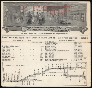
The Wanamaker Vest Pocket Subway Guide / The Wanamaker Station in the Subway at Astor Place.
sold
- Digital Map Information
- Suitable for large format printing
- Full resolution TIFF file
- ICC color profile embedded
- Delivered instantly via download link
This 1904-07 Wanamaker Vest Pocket Subway Guide is one of only four known surviving examples of the first subway map intended for public use. It was printed in 1904 on behalf of, or by, Wanamaker's department stores to promote their expanded New York City location, which featured an underground entrance to the Astor Place subway station. That busy subway platform is pictured here in an image entitled 'The Wanamaker Station in the Subway at Astor Place,' showing fashionably-dressed New Yorkers at the entrance to the Wanamaker's store (pointed out to the reader with the red, hand-stamped note, 'Direct Entrance from Subway to the Wanamaker Store Now Open.')andnbsp; A train, with its taillight shining, can be seen leaving on the uptown track. Below this vignette are a timetable and a map of the nascent subway (then extending from Brooklyn Bridge to 145th Street.) Special attention, naturally, is given on both the map and timetable to the Astor Place stop with its underground Wanamaker's storefront. Although Wanamaker's is long defunct, the same entrance is today used by the sole K-Mart in Manhattan. (more details)
Philadelphia Sesquicentennial Exposition.

Map of the City of Philadelphia. John Wanamaker Philadelphia.
sold
- Digital Map Information
- Suitable for large format printing
- Full resolution TIFF file
- ICC color profile embedded
- Delivered instantly via download link
This is a detailed 1917 plan of the city of Philadelphia, published by the pioneer merchant and advertiser John Wanamaker. Not only a promoter of his stores, Wanamaker was a civic booster for Philadelphia and published several historical and laudatory works about the city. The 1917 Guide included the present map - both for the edification and use of visitors, but also to promote the Philadelphia Sesquicentennial Exposition, which Wanamaker proposed in 1916 to take place in 1926. The map illustrates the suggested site for the Exposition, along the Benjamin Franklin Parkway then under construction and named Park Boulevard on the plan. (more details)