
Whitney, William Henry (sold)

William Henry Whitney (January 3, 1843 - May 4, 1909) was an American civil engineer active in Boston in the second half of the 19th century. Whitney was born in Needham, Massachusetts. He studied at Cambridge High School then at the Lawrence Scientific School of Harvard University. In July of 1862, he enlisted in the Union Army to fight in the American Civil War (1861 - 1865). He served honorably throughout the war, seeing action and suffering wounds twice. He left the service with the rank of Brevet-Major. He served as Alderman of Cambridge. and was involved with the Back Bay development project - producing multiple maps and plans. He began his studies as a civil engineer before the war in the office of Stephen P. Fuller. From 1869 - 1871 he worked in the Boston City Engineer's Office and was involved with the Back Bay development project - producing multiple maps and plans. In 1872, he entered into partnership with J. Franklin Fuller, son of S. P. Fuller. After a short time, Fuller retired and Whitney took full control of the firm, in 1888 renaming it William H. Whitney. As a private contractor he continued to work on the Back Bay. Also around this time, he completed multiple plans for the official records of the Civil War. Between 1889 and 1890, he took a contract with the Union Pacific to produce a series of maps of western cities, including Portland, Salt Lake City, Seattle, Astoria, Port Townsend, Spokane, and more. While he did not consider them an important part of his corpus, they are today arguably his most significant works, being among the earliest obtainable plans of those cities. He was also influential in introducing blueprint technology to American architecture and engineering.
The must unusual of Whitney's railroad maps.
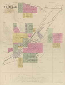
Whitney's Map of Trinidad, Colorado.
sold
- Digital Map Information
- Suitable for large format printing
- File Size: 11.76 MB
- File Type: ZIP / TIFF
- ICC color profile embedded
- Delivered instantly via download link
An extremely rare 1888 map of Trinidad, Colorado, issued by W. H. Whitney. The map was issued at a heady time in Trinidad's development. The railroads reached Trinidad in the late 1870s, ushering in a boom that lasted until the turn of the century. As a railroad nexus connecting three major lines, Trinidad prospered as a cattle town. Towards the end of the 19th century, massive coal deposits were discovered that further fueled growth. When this map was issued, legendary lawman Bat Masterson was the town marshal, and other colorful characters associated with the old west visited, including Doc Holliday and Wyatt Earp. (more details)
The best early map of Salt Lake City.
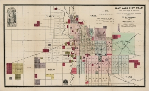
Salt Lake City, Utah.
sold
- Digital Map Information
- Suitable for large format printing
- Full resolution TIFF file
- ICC color profile embedded
- Delivered instantly via download link
This is the rare 1889 W. H. Whitney and Simon F. Mackie map of Salt Lake City, Utah. The map illustrates the early days of Salt Lake City as a stop on the Rio Grande Western Railway. This is one of Whitney's earliest maps of western cities, predating his contract with the Union Pacific. It combines the functions of a real estate map and a railroad map. An inset in the upper left offers an overview of the general area. (more details)
One of the earliest obtainable plans of Portland, Oregon.
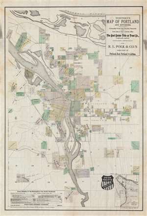
Whitney's Map of Portland and Environs.
sold
- Digital Map Information
- Suitable for large format printing
- File Size: 50.63 MB
- File Type: ZIP / TIFF
- ICC color profile embedded
- Delivered instantly via download link
A fine example of W. H. Whitney's important 1889 map of Portland, Oregon, one of the earliest obtainable maps of that city. It emphasizes the growing transportation networks including the Union Pacific-owned and connected Oregon Railway and Navigation Lines, and the competing Northern Pacific Railroad. Connecting railroads, projected roadways, and streetcar lines are also noted. It is one of a series of important maps of Pacific Northwest cities serviced by (or of interest to) the Union Pacific introduced by W. H. Whitney between 1889 and 1890. (more details)
Bellingham as a railroad town.
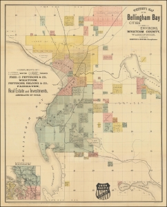
Whitney's Map of the Bellingham Bay Cities and Environs, Whatcom County, Washington.
sold
- Digital Map Information
- Suitable for large format printing
- File Size: 27.26 MB
- File Type: ZIP / TIFF
- ICC color profile embedded
- Delivered instantly via download link
This is the rare 1890 W. H. Whitney and Edmund S. Hincks map of Bellingham, Washington. The map illustrates the early attempts of Bellingham to connect to an international railroad. Although bearing the Union Pacific Railroad, that line never connected to Bellingham Bay. Instead, the services here reflect connections to the competing Canadian Pacific and Great Northern Lines. It combines the function of a real estate map and a railroad map. An inset in the upper left offers an overview of the general area. The map covers the entrance to the Straits of Juan de Fuca, highlighting the Bellingham Bay cities of Bellingham and Fairhaven as far east as Lakes Whatcom and Samish. (more details)
Tacoma as a railroad town.
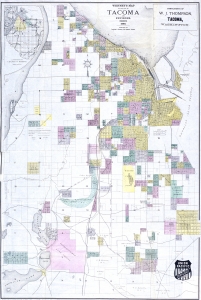
Whitney's Map of the City of Tacoma and environs, Washington.
sold
- Digital Map Information
- Suitable for large format printing
- Full resolution TIFF file
- ICC color profile embedded
- Delivered instantly via download link
This is the rare 1889 W. H. Whitney and Frederick G. Plummer map of Tacoma, Washington. The map illustrates the early days of Tacoma as a stop on the Union Pacific's Northern Pacific Railroad. It combines the functions of a real estate map and a railroad map. An inset in the upper left offers an overview of the general area. (more details)
Tacoma as a railroad town.
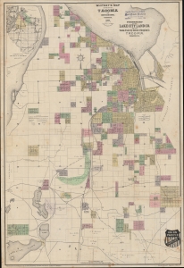
Whitney's Map of the City of Tacoma and environs, Washington.
sold
- Digital Map Information
- Suitable for large format printing
- File Size: 1186.34 MB
- File Type: ZIP / TIFF
- ICC color profile embedded
- Delivered instantly via download link
This is the rare 1889 W. H. Whitney and Frederick G. Plummer map of Tacoma, Washington. The map illustrates the early days of Tacoma as a stop on the Union Pacific's Northern Pacific Railroad. It combines the functions of a real estate map and a railroad map. An inset in the upper left offers an overview of the general area. (more details)
Astoria as a railroad town.
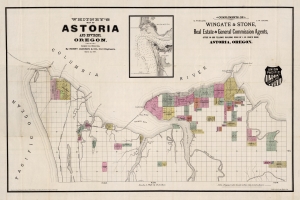
Whitney's Map of Astoria and Environs, Oregon.
sold
- Digital Map Information
- Suitable for large format printing
- Full resolution TIFF file
- ICC color profile embedded
- Delivered instantly via download link
This is the rare 1890 W. H. Whitney and Henry Jackson map of Astoria, Oregon. The map illustrates the early days of Astoria as it attempted to build railroad connections to the Northern Pacific. The route of the South Coast Railway towards Warrenton and Seaside is noted. Another line, the Albany and Astoria Railway, was a proposed route southward through the Grand Konde Indian Reservation. The line met with considerable opposition both from the tribe and from congress and was never authorized. It combines the function of a real estate map and a railroad map. (more details)
Port Townsend wants a railroad!
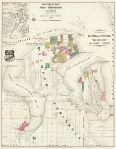
Whitney's Map of Port Townsend and Environs.
sold
- Digital Map Information
- Suitable for large format printing
- File Size: 28.42 MB
- File Type: ZIP / TIFF
- ICC color profile embedded
- Delivered instantly via download link
This is the rare 1890 W. H. Whitney and 'Miller and Going' map of Port Townsend, Washington. The map illustrates the early days of Port Townsend as it struggled to develop railroad connections. Although a prosperous port town, Port Townsend, situated on wrong side of the Puget sound, was too far and difficult to access to attract the attention of the Northern Pacific. This map instead captures grassroots efforts of Port Townsend residents to develop their own lines - the Port Townsend Southern and the Port Townsend and Southern Railroad to Quilcene. It combines the function of a real estate map and a railroad map. An inset in the upper left offers an overview of the general area. The map covers the entrance to the Straits of Juan de Fuca, Port Discovery, Port Townsend Bay, and Scow Bay (Long Harbor) to western Whidbey Island. (more details)
Seattle as a railroad town.
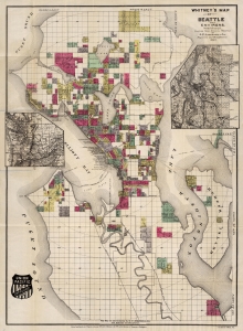
Whitney's Map Of Seattle And Environs, Washington.
sold
- Digital Map Information
- Suitable for large format printing
- Full resolution TIFF file
- ICC color profile embedded
- Delivered instantly via download link
This is the rare 1890 W. H. Whitney and Oliver Phelps Anderson map of Seattle. The map illustrates the early days of Seattle as a stop on the Union Pacific Railroad. It combines the function of a real estate map and a railroad map. (more details)
Manuscript planning map of the Fens.
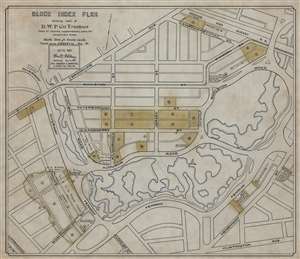
Block Index Plan Showing land of B.W.P. Co. Trustees.
sold
- Digital Map Information
- Suitable for large format printing
- File Size: 56.95 MB
- File Type: ZIP / TIFF
- ICC color profile embedded
- Delivered instantly via download link
This is a 1901 William H. Whitney manuscript map of the Back Bay Fens and the Fenway - Kenmore neighborhood in Boston, Massachusetts. Coverage extends from Brookline Avenue to Huntington Avenue, but the Fens dominate the map, with the waterways emphasized in light blue. Land owned by the Boston Water Power Company is in toned yellow or green. (more details)