

Louisiana.
sold
- Digital Map Information
- Suitable for large format printing
- File Size: 7.73 MB
- File Type: ZIP / TIFF
- ICC color profile embedded
- Delivered instantly via download link
A beautiful 1855 first edition example of Colton's map of Louisiana. Covers the entire state as well as adjacent parts of Texas and Mississippi. Like most of Colton's state maps, this map is largely derived from an earlier wall map of North America produced by ... (more details)

Minnesota.
sold
- Digital Map Information
- Suitable for large format printing
- File Size: 7.1 MB
- File Type: ZIP / TIFF
- ICC color profile embedded
- Delivered instantly via download link
A beautiful 1855 first edition first state example of Colton's map of Minnesota. This is one of the rarest and most desirable of all Colton atlas maps. Like most of Colton's state maps, this map was derived from an earlier wall map of North America produced by ... (more details)

California. City of San Francisco.
sold
- Digital Map Information
- Suitable for large format printing
- File Size: 8.64 MB
- File Type: ZIP / TIFF
- ICC color profile embedded
- Delivered instantly via download link
Issued roughly six years after the 1849 California Gold Rush, this is a beautiful 1855 first edition first state example of Colton's map of California. Colton's California with its San Francisco inset is one of the rarest and most desirable of all Colton atlas ... (more details)
Rare first edition of an important Pacific Northwest map.
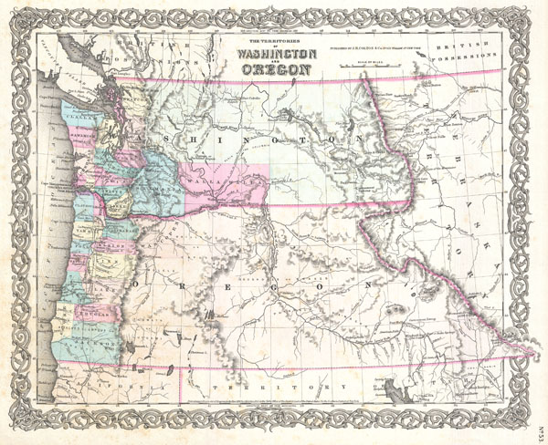
The Territories of Washington and Oregon.
sold
- Digital Map Information
- Suitable for large format printing
- File Size: 6.98 MB
- File Type: ZIP / TIFF
- ICC color profile embedded
- Delivered instantly via download link
A beautiful 1855 first edition first state example of Colton's map of the territories of Washington and Oregon. This is one of the rarest and most desirable of all Colton atlas maps. Based on earlier wall map produced by Colton and D. Griffing Johnson, this ... (more details)
One of the rarest and most desriable U.S. Coast Survey maps of the Chesapeake Bay.
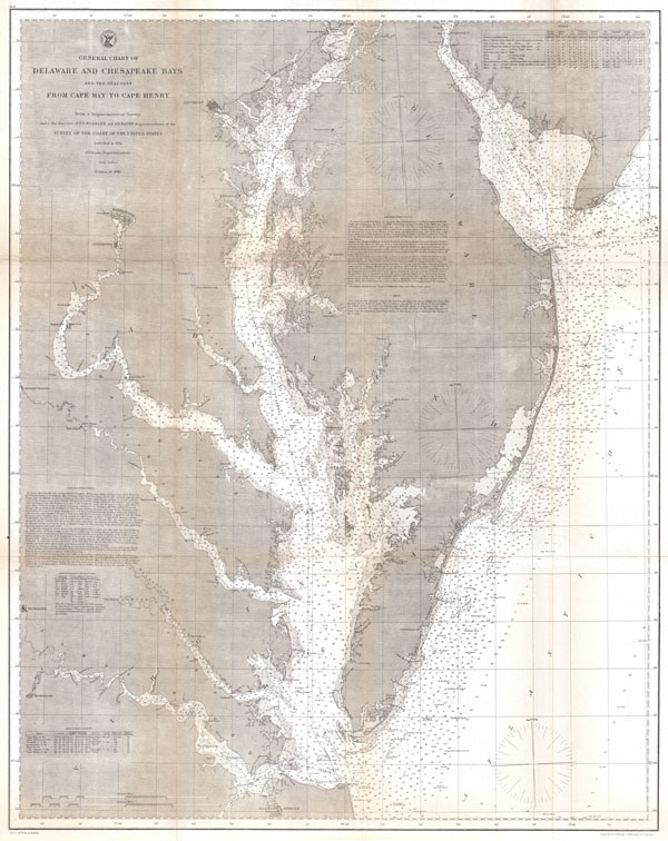
General Chart of Delaware and Chesapeake Bays and the Sea Coast from Cape May to Cape Henry.
sold
- Digital Map Information
- Suitable for large format printing
- File Size: 33.8 MB
- File Type: ZIP / TIFF
- ICC color profile embedded
- Delivered instantly via download link
An extraordinary 1866 U.S. Coast Survey nautical chart or map of the Chesapeake Bay and Delaware Bay. This is one of the rarest and most desirable charts issued by the U.S. Coast Survey. Covers from Norfolk Virginia and Cape Henry north to Cape Map and ... (more details)

Massachusetts Boston Bay Sheet.
sold
- Digital Map Information
- Suitable for large format printing
- File Size: 10.45 MB
- File Type: ZIP / TIFF
- ICC color profile embedded
- Delivered instantly via download link
One of the more sought after topographical maps produced by the U.S. Geological Survey. The 1900 edition of the U.S.G.S. Survey Map of Boston Bay covers from Salem to Waymouth, Hingham and Cohasset. Offers extraordinary detail to the level of streets ... (more details)

Massachusetts Boston Sheet.
sold
- Digital Map Information
- Suitable for large format printing
- File Size: 12.6 MB
- File Type: ZIP / TIFF
- ICC color profile embedded
- Delivered instantly via download link
One of the most sought after topographical maps produced by the U.S. Geological Survey. The 1900 edition of the U.S.G.S. Survey Map of Boston and vicinity covers from Burlington to Dedham and from Waltham to Boston Harbor. Offers extraordinary detail ... (more details)

Massachusetts Gay Head Sheet.
sold
- Digital Map Information
- Suitable for large format printing
- File Size: 9.54 MB
- File Type: ZIP / TIFF
- ICC color profile embedded
- Delivered instantly via download link
One of the most sought after topographical maps produced by the U.S. Geological Survey. The 1898 edition of the U.S.G.S. Survey Map of Gay Head, Marthas Vineyard covers the Western part of the island including Gay Head and Chilmark. Also covers parts ... (more details)
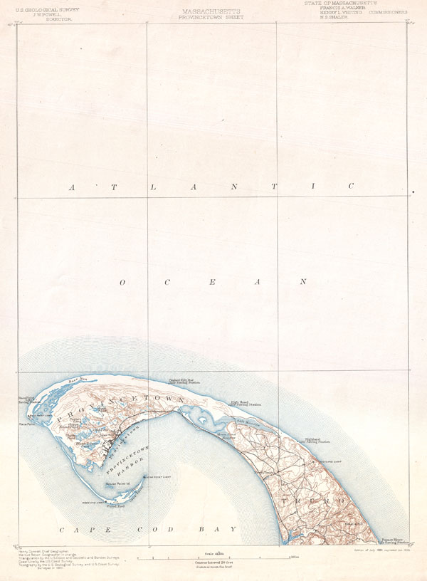
Massachusetts Provincetown Sheet.
sold
- Digital Map Information
- Suitable for large format printing
- File Size: 5.91 MB
- File Type: ZIP / TIFF
- ICC color profile embedded
- Delivered instantly via download link
One of the most sought after topographical maps produced by the U.S. Geological Survey. The 1900 edition of the U.S.G.S. Survey Map of Provincetown covers the norther tip of Cape Cod. Shows Provincetown itself with detail to the level of individual ... (more details)
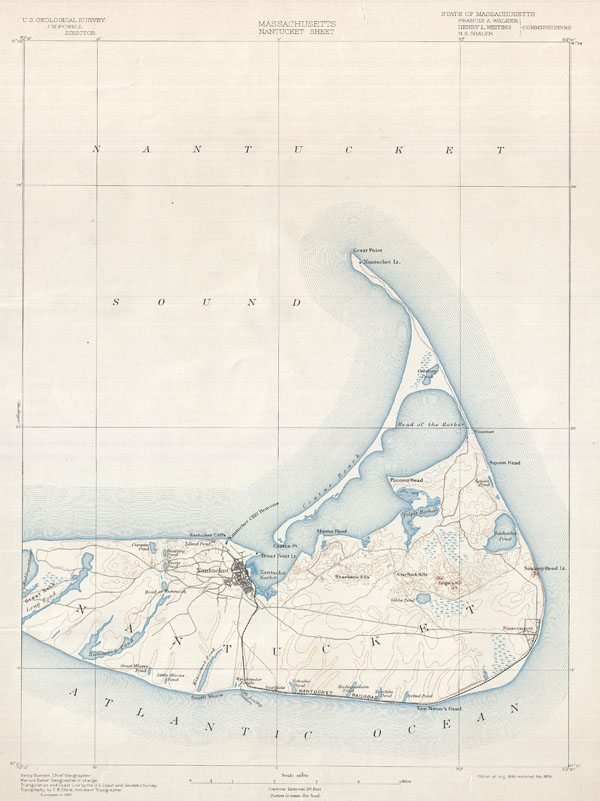
Massachusetts Nantucket Sheet.
sold
- Digital Map Information
- Suitable for large format printing
- File Size: 7.74 MB
- File Type: ZIP / TIFF
- ICC color profile embedded
- Delivered instantly via download link
One of the most sought after topographical maps produced by the U.S. Geological Survey. The 1898 edition of the U.S.G.S. Survey Map of Nantucket covers the island from Great Neck to the Atlantic. Identifies topographical features such as the ... (more details)
Predates the formation of Nevada and Arizona.

Territories of New Mexico and Utah.
sold
- Digital Map Information
- Suitable for large format printing
- File Size: 7.78 MB
- File Type: ZIP / TIFF
- ICC color profile embedded
- Delivered instantly via download link
An iconic map of the American west and one of the rarest and most desirable of all Colton atlas maps. This is an extraordinary example of the first edition first state of Colton's 1855 map of the territories of New Mexico and Utah. This is ... (more details)
Shows territorial Nebraska extending to the Canadian border.

Nebraska and Kansas.
sold
- Digital Map Information
- Suitable for large format printing
- File Size: 7.9 MB
- File Type: ZIP / TIFF
- ICC color profile embedded
- Delivered instantly via download link
A beautiful 1855 first edition example of Colton's map of Nebraska and Kansas. This is most probably the rarest and most desirable of all Colton atlas maps. Based on earlier wall map produced by Colton and D. Griffing Johnson, this map ... (more details)
First atlas edition of Colton's iconic Texas map.

Texas.
sold
- Digital Map Information
- Suitable for large format printing
- File Size: 7.18 MB
- File Type: ZIP / TIFF
- ICC color profile embedded
- Delivered instantly via download link
A beautiful 1855 first edition example of Colton's map of Texas. Largely based on the important De Cordova map of Texas, this map covers the entire state as well parts of adjacent New Mexico, Arkansas and the Indian Territory (Oklahoma). ... (more details)
Predates Virginia - West Virginia split.

Virginia.
sold
- Digital Map Information
- Suitable for large format printing
- File Size: 8.28 MB
- File Type: ZIP / TIFF
- ICC color profile embedded
- Delivered instantly via download link
A beautiful 1855 first edition example of Colton's map of Virginia. Covers the entire state as well most of adjacent Maryland and parts of North Carolina, Kentucky and Tennessee. Predates split with West Virginia by seven years. Map is ... (more details)

North Carolina.
sold
- Digital Map Information
- Suitable for large format printing
- File Size: 8.35 MB
- File Type: ZIP / TIFF
- ICC color profile embedded
- Delivered instantly via download link
A beautiful 1855 first edition example of Colton's map of North Carolina. Covers the entire state as well as adjacent parts of South Carolina and Virginia. Map is hand colored in pink, green, yellow and blue pastels to identify ... (more details)

South Carolina.
sold
- Digital Map Information
- Suitable for large format printing
- File Size: 8.22 MB
- File Type: ZIP / TIFF
- ICC color profile embedded
- Delivered instantly via download link
A beautiful 1855 first edition example of Colton's map of South Carolina. Covers the entire state as well as adjacent parts of Georgia and North Carolina. Map is hand colored in pink, green, yellow and blue pastels to identify ... (more details)

The City of Chicago, Illinois. The City of St. Louis, Missouri.
sold
- Digital Map Information
- Suitable for large format printing
- File Size: 6.72 MB
- File Type: ZIP / TIFF
- ICC color profile embedded
- Delivered instantly via download link
A beautiful 1855 first edition example of Colton's rare two part map of Chicago, Illinois and St. Louis, Missouri. Sheet is divided into two sections. Both are hand colored in pink, green, yellow and blue pastels to identify ... (more details)

The City of Pittsburgh, Pennsylvania. The City of Cincinnati, Ohio.
sold
- Digital Map Information
- Suitable for large format printing
- File Size: 7.33 MB
- File Type: ZIP / TIFF
- ICC color profile embedded
- Delivered instantly via download link
A beautiful 1855 first edition example of Colton's rare two part map of Pittsburgh, Pennsylvania and Cincinnati, Ohio. Map is divided into two sections. Both are hand colored in pink, green, yellow and blue pastels to ... (more details)
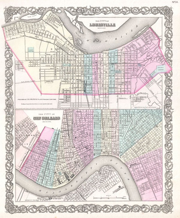
The City of New Orleans, Louisiana. The City of Louisville, Kentucky.
sold
- Digital Map Information
- Suitable for large format printing
- File Size: 7.99 MB
- File Type: ZIP / TIFF
- ICC color profile embedded
- Delivered instantly via download link
A beautiful 1855 first edition example of Colton's rare two part map of New Orleans, Louisiana and Louisville, Kentucky . Map is divided into two sections. Both are hand colored in pink, green, yellow and blue pastels ... (more details)

The City of Savannah Georgia. The City of Charleston South Carolina.
sold
- Digital Map Information
- Suitable for large format printing
- File Size: 6.81 MB
- File Type: ZIP / TIFF
- ICC color profile embedded
- Delivered instantly via download link
An excellent 1855 first edition example of Colton's rare two part map of Savannah, Georgia and Charleston, South Carolina . Map is divided into two sections. Both are hand colored in pink, green, yellow and blue ... (more details)